Connected by Water - South Yorkshire - Information Page
Overview
Welcome to the Connected by Water Information Page
Connected by Water is a South Yorkshire alliance working with communities and businesses to build flood resilience and reduce the impact of the climate emergency. Our vision is a flood resilient South Yorkshire.
Flood resilience is the ability to prepare for flooding, act safely, minimise damage and recover from flooding when it occurs.
We have created this page to provide easy access to information about our work and to signpost to other information and resources about flooding.
We will update this page as we progress with Connected by Water, so please keep checking regularly for new information.

What is Connected by Water?
Connected by Water is an alliance between the South Yorkshire Mayoral Combined Authority, Barnsley Metropolitan Borough Council, City of Doncaster Council, Rotherham Metropolitan Borough Council, Sheffield City Council, Yorkshire Water and the Environment Agency.
The flooding in November 2019 provided the catalyst for the creation of the alliance and for the first Connected by Water Action Plan. One of the wettest autumns on record led to unprecedented river levels, and widespread flooding across South Yorkshire. Leaders in the region came together to develop an ambitious new flood risk programme for South Yorkshire and to make the case for significant funding. This was the beginning of Connected by Water.
Since November 2019 we’ve been working together, not only to deliver flood risk management schemes on the ground, but also to plan catchment-wide measures for the future to help meet the challenges of climate change.
We aim to better protect 25,000 homes, businesses, and regionally significant infrastructure through a range of projects.
We are exploring all measures to both adapt to and mitigate the impacts of climate change across South Yorkshire and to reduce the impacts of flooding. Our Action Plan is a 'living plan' because we don't yet have all the answers. We are building and shaping this plan based on emerging data, knowledge and opportunities, and will continue to do this over the coming months and years.
You can read the Connected by Water Action Plan here.
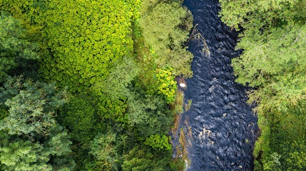
Photo: The front image of the Connected by Water Action Plan showing a river passing through vegetation
How we work
Working in partnership
We work in partnership across South Yorkshire. This means working with different groups and organisations to make the most of our combined skills, experience, resources and perspectives. Our aspiration is to work with and involve many more in a collective effort to increase our resilience to flooding and climate change. This includes organisations, academics and experts, communities, businesses, farmers, landowners and schools across the region.
We ran a consultation in 2022 to widen awareness of Connected by Water and seek views from the public, organisations including the voluntary sector, businesses, landowners, and other interested bodies. The results are available here: Connected by Water South Yorkshire Action Plan
A Catchment-based approach
In Connected by Water we take a catchment-based approach to managing the risks of flooding. This approach covers the whole of the Don catchment, extending into Derbyshire which falls outside South Yorkshire.
A catchment is an area of land where water collects when it rains. It is determined by natural features and is often bounded by hills or mountains. Water runs off the high ground and flows to a low point, such as a river, lake, reservoir, wetland or the sea.
Catchments are complex and something happening in one part of the catchment can have a big impact on other parts. That’s why it’s crucial to think about the catchment as a whole and coordinate activities between the many organisations and people who manage land and water within it.
The River Don catchment
South Yorkshire covers largely the same geographical area as the catchment of the River Don. The Don is a large river flowing for approximately 70 miles from its headwaters in Dunford Bridge in the Peak District to Goole where it joins the River Ouse. You can see the route of the River Don in the maps below.
The Don catchment is complex and highly varied, ranging from the upland hills of the Peak District to the lowlands of Doncaster where the River Don meets the Humber Estuary.
Because of this, we think about the catchment as having three sub regions:
The Upper Don
The River Don rises in the Peak District. This part of the catchment has large areas of moorland, farms, rural estates, and further downstream, the city of Sheffield.
The Middle Don
This part of the catchment has the towns and villages of North East Derbyshire, Rotherham and Barnsley, as well as wetland nature reserves alongside the River Dearne and River Rother in Barnsley and Rotherham, and farmland.
The Lower Don
As well as the City of Doncaster there are nationally significant lowland peat bogs around the Lower Don in Doncaster, and areas of farmland.
The River Don is one of a number of rivers in South Yorkshire. The Don catchment also contains lots of smaller rivers, becks, brooks and streams such as the Loxley, Dove, Went and Rivelin. Other rivers in the catchment include:
River Rother
This river, which gives its name to the town of Rotherham, rises in Pilsley in North East Derbyshire. It flows northwards to feed the Chesterfield Canal, and on through several districts of Sheffield before joining the River Don near Templeborough in Rotherham.
River Dearne
The River Dearne flows eastwards from its source in Denby Dale for over 30 miles through Darton and Barnsley until it meets the River Don at Denaby Main, a village between Mexborough and Conisbrough near Doncaster.
River Sheaf
This finds its source amongst the Pennines and flows northwards past Dore, eventually flowing under the centre of Sheffield before joining the River Don. Sheffield takes its name from the River Sheaf.
Porter Brook
The Porter Brook also flows through Sheffield, descending 300 metres from its source in Burbage Moor to its mouth where it meets the River Sheaf.
The Don Catchment Rivers Trust and Sheaf and Porter Rivers Trust have excellent information about the catchment and its rivers.
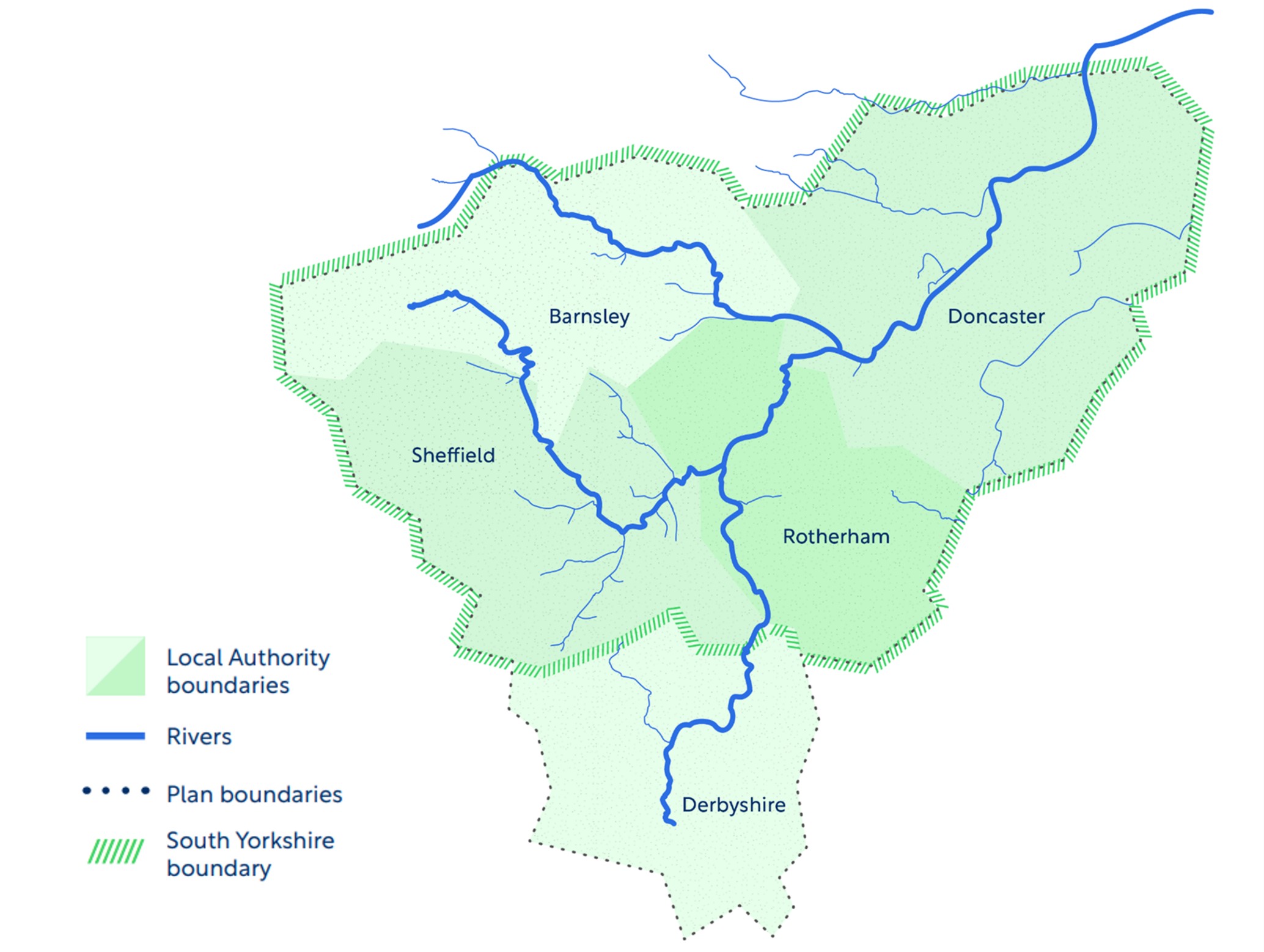
Map 1: A simple map of South Yorkshire showing the route of the River Don and our local authority areas. Source: Connected by Water
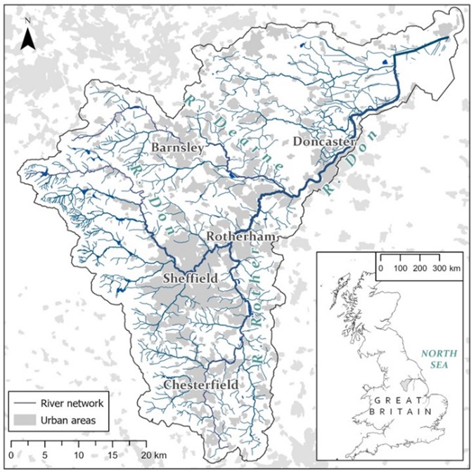
Map 2: A map of South Yorkshire showing the main rivers and urban areas. Source: Don Catchment Rivers Trust
Flooding in South Yorkshire
There have been devastating floods from rivers and heavy rainfall in South Yorkshire with two major floods in the last 16 years, in 2007 and 2019. There has also been flooding from sources other than rivers. You can find out more about types of flooding in the section below.
The impact of flooding is far reaching. It can cause serious injury and loss of life. It leads to long term misery for those whose homes have flooded, severely affecting mental health and wellbeing. For every single person whose home is flooded, it is estimated that sixteen further people are impacted.
Flooding disrupts businesses, transport infrastructure, utilities, workplaces and public services (including health care, emergency services, social care and schools). It can impact on food and farming when agricultural land is flooded. The risk of flooding can also prevent economic regeneration, stop new housing being built and cause businesses to close with resulting job losses.
Through Connected by Water we aim to better protect 25,000 homes, businesses, and regionally significant infrastructure through a range of projects.
History of flooding in South Yorkshire
No two flood events are the same and the impacts depend on a range of factors including the time of year, duration of rainfall, ground conditions and level of preparation.
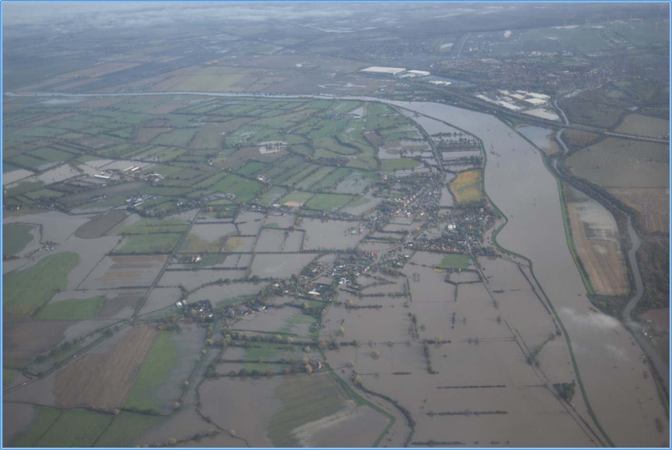
Photo: Flooding in Fishlake (2019)
November 2019
The flooding in South Yorkshire in November 2019 followed two months where rainfall was more than twice the monthly average. Persistent heavy rain on 7 and 8 November caused river levels to rise rapidly. In just 48 hours 150% of the average November monthly rainfall fell over the middle reaches of the River Don resulting in widespread impacts across South Yorkshire. Overall, river levels equalled or exceeded the previous record event of June 2007.
This extreme rainfall led to one of the largest flood events in the last 50 years of records in the Don catchment, and had a devastating impact on communities along the River Don. Around 1600 properties were affected by the flooding, with the majority in Doncaster (in Bentley and Fishlake). 1200 homes were evacuated and the flooding affected key roads, rail infrastructure and areas of farmland.
Despite the event being similar in scale to the flooding in 2007, the damage was less widespread and 7000 properties were protected by flood defences.
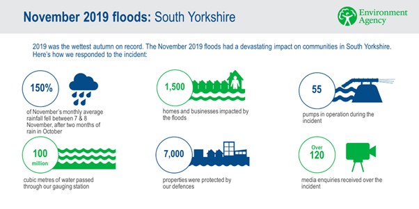
Details of the November 2019 floods and the impact
June 2007
The floods of June 2007 were also historically significant events in the Don catchment.
As in 2019, a period of intense heavy rainfall caused rivers to reach their limits and overtop. As can be seen in the graph below, river levels at their peak were similar in November 2019 and June 2007.
The impacts of the 2007 floods were devastating. 3060 residential properties and 1300 business premises were flooded. 10 schools had to be closed and two people in Sheffield lost their lives.
There were many more issues in 2007, with blockages to watercourses and damage to existing flood defences. This in part will have contributed to the significant impacts seen in 2007.
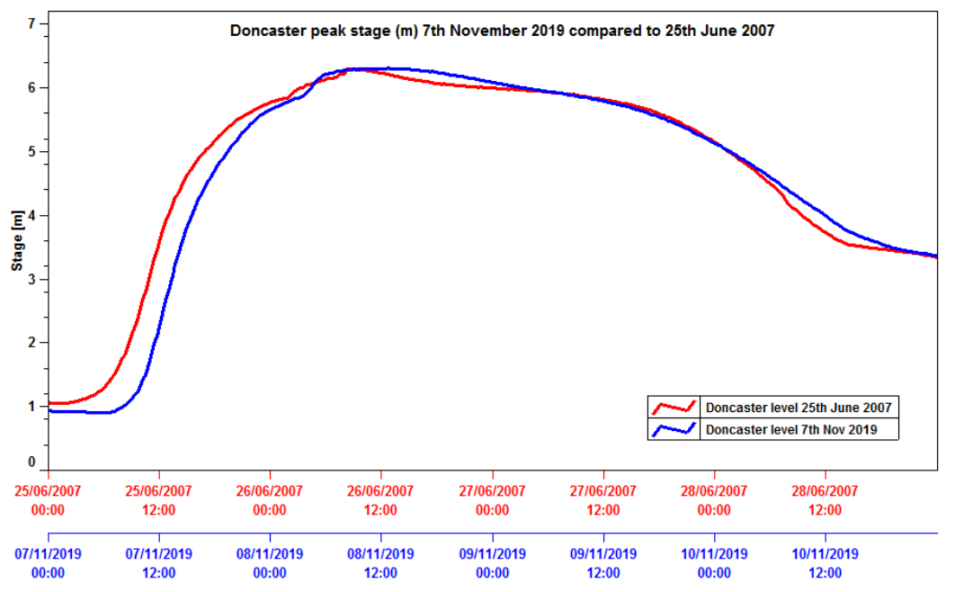
Graph: Severity of the 7 November 2019 event compared to 25 June 2007 event, as demonstrated at Doncaster flow gauge on the River Don
Types of flooding
Flooding can come from a variety of sources. As well as flooding from rivers, South Yorkshire is affected by surface water flooding and sewer flooding. These can happen during periods of heavy rainfall and where there are blockages in drains. Through Connected by Water we are addressing all types of flooding that affect South Yorkshire.
This summary gives an overview of the different types of flooding and which organisation the flooding should be reported to: Types of flooding
You can find out how to prepare for flooding and take action in the section What you can do to prepare for flooding and reduce risk.
Fluvial (river) flooding
River flooding, also known as fluvial flooding, occurs when the capacity of a river’s channel is exceeded as a result of intense or sustained rainfall across the catchment. The river then breaches its banks. This can happen on any river or watercourse.
Surface water flooding
Also known as pluvial flooding, surface water flooding occurs when the volume of rainfall is greater than the capacity of drains and surface water sewers. When this happens, the water is unable to drain away through drainage systems or soak into the land, and instead flows over the land. The intensity of this flooding can be increased by blocked road gullies, drains and sewers.
Sewer flooding
Sewer flooding is the overflow of water from the drainage and sewerage system. It can be the result of damage in the sewers, or the capacity of the system may be overwhelmed by heavy rain. Sewer flooding is hazardous, as the water contains bacteria and contaminants. Waste water and sewage can overflow into residential areas, posing a risk to human health and safety.
Most sewer flooding incidents are the result of overloaded sewers following heavy rainfall, or due to blockages caused by misuse of the sewer system (such as flushing unsuitable items, such as wet wipes, down the toilet).
Canal flooding
Canal flooding occurs when the level of water in the canal is too high and overtops. Canal flooding is rare, but even with the best controls in place there can sometimes be too much water to manage.
Source of definitions: The Flood Hub
Climate change
As a result of climate change, the UK is expected to experience hotter, drier summers and warmer, wetter winters, with increases in the intensity of summer and autumn rainfall events.
Sea levels around the UK will continue to rise. In Yorkshire, if temperatures were to increase by 4°C, based on planning for the worst case, we would expect to see a 0.53 to 1.15 metre rise in sea level by 2100. This will increase flows on tidal rivers, including the Lower Don.
Due to the combination of a projected increase in rainfall and sea level rise, flooding in South Yorkshire will become more frequent and severe in the future.
Our projects in South Yorkshire
We are exploring all measures to adapt to and mitigate the impacts of climate change across South Yorkshire and to reduce the impacts of flood events.
We have made good progress in the Connected by Water alliance, delivering flood alleviation schemes and building our capacity to respond to floods across South Yorkshire. However, there is much still to do and some communities and businesses remain vulnerable.
The section below gives a flavour of the projects and schemes that are being carried out across the catchment.
You can view our Action Plan here or watch this video which gives an overview of our projects.
Our Local Authority areas
You can find further information about schemes and projects to reduce the risk of flooding in your local area through the following Local Authority websites:
Barnsley Metropolitan Borough Council
Rotherham Metropolitan Borough Council
Flood Alleviation Schemes (FAS)
A flood alleviation scheme is designed to reduce flood risk to homes and businesses in an area identified as being at significant risk from flooding. These schemes typically involve multiple projects and engagement with the public, businesses and landowners.
An example of this is the Rotherham Renaissance Flood Alleviation Scheme:
Rotherham Renaissance FAS
This is one of six priority flood alleviation schemes in Rotherham. Rotherham Metropolitan Borough Council is working in partnership with the Environment Agency, South Yorkshire Mayoral Combined Authority, Network Rail, the Canal & River Trust, and many other organisations and landowners to deliver these schemes, in order to reduce flood risk across the borough.
When complete, the Rotherham Renaissance FAS will extend along five kilometres of the River Don through Templeborough, Rotherham town centre and Parkgate.
The Templeborough phase of the scheme was completed in 2008, at a cost of £15.7 million. Between 2009 and 2011, a further £1.3 million was spent on the Rotherham town centre phase.
Most recently a canal barrier has been constructed at Forge Island. It is designed to reduce the risk of flooding in the town centre and Rotherham Central railway station. Construction of the barrier began in August 2021 and was completed in August 2022.
To date, the scheme has reduced the risk of flooding to key roads, the rail network and over 100 businesses. It has improved key employment areas in Rotherham through securing existing jobs and creating new ones.
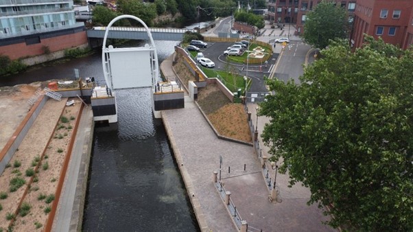
Photo: Canal barrier at Forge Island, Rotherham
Improvements to flood defences
A lot of work goes on behind the scenes, all year round, to maintain flood defences in South Yorkshire.
Fishlake, Doncaster
Following the devastating impact of the 2019 flood, £3 million of funding was allocated to carry out recovery work in Fishlake. This work was completed in June 2021 and included strengthening embankments and improving the condition of existing defences.
With much of the work being carried out during the COVID-19 pandemic, a key part of delivering the work was the proactive use of different methods of communication between the Environment Agency, City of Doncaster Council, local community groups and other partners. Examples included regular online meetings of Fishlake Parish Council and the local Flood Action Group and the sending out of regular newsletters. This enabled key information and any issues to be shared and dealt with quickly.
Overall, this investment will improve and sustain the future performance of critical flood defences for the area.
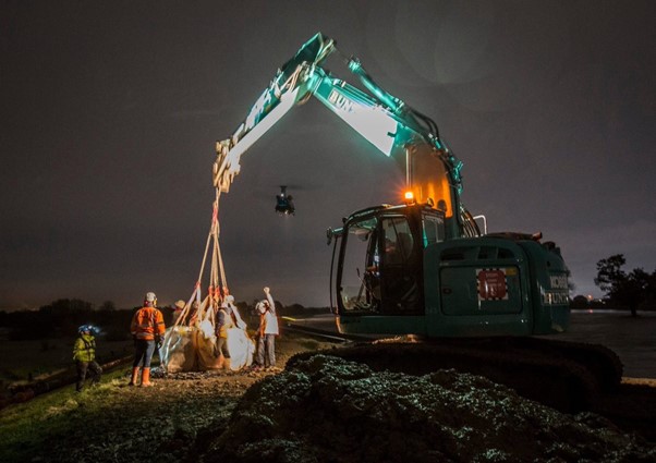
Photo: Work on flood defences in Fishlake, Doncaster (2019)
Bentley Ings Pumping Station, Doncaster
Bentley Ings Pumping Station was built in the early 1940s to manage surface water because of mining subsidence. It is a key flood defence which protects 1669 local properties from flooding.
Following the completion of a £12 million refurbishment scheme in 2021, it has been transformed. Its capacity has been increased so that the station can now handle 20% more water. The refurbishment has also achieved a carbon saving by reusing existing concrete and using modern pumps. The site is now significantly more flood resilient, allowing access to the site and the pumps to continue operating during flood events.
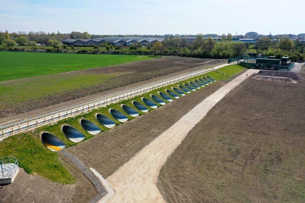
Photo: Bentley Ings Pumping Station, Doncaster
Nature-based solutions
Nature-based solutions involve working with natural processes to respond to issues such as flooding and the loss of biodiversity.
The landscapes and rivers which make South Yorkshire vulnerable to flooding are also some of its most precious assets. The uplands of the Porter Brook, the River Rivelin and the River Loxley in Sheffield, and the River Don in Barnsley, give us beautiful moorland landscapes. These uplands supply water to wetland nature reserves along the Dearne and Rother in Barnsley and Rotherham, and further downstream to nationally significant lowland peat bogs around the Lower Don in Doncaster. Some of these landscapes have become degraded over time.
Restoring and developing these natural landscapes will help to slow and store water, help nature recover, and provide wildlife-rich environments for people to thrive in. This will not only reduce flood risk, but also mitigate climate change by storing carbon and restore nature by protecting the environment.
Nature-based solutions form a key part of the Connected by Water Action Plan.
Source to Sea
We are collaboratively developing a multi-million pound Source to Sea nature-based solutions programme in the Don Catchment. This programme is split into three areas: the Upper Don (Peak District National Park and Sheffield), Middle Don (North East Derbyshire, Rotherham and Barnsley) and the Lower Don (Doncaster).
Each of these will build upon existing projects, partnerships, local strategies and initiatives to implement a variety of nature-based solutions to slow the flow and create more space for water in the landscape. We are considering measures such as restoring upland peatlands, creating ponds and wetlands, and soil management to hold more water in the landscape and reduce run-off into watercourses.
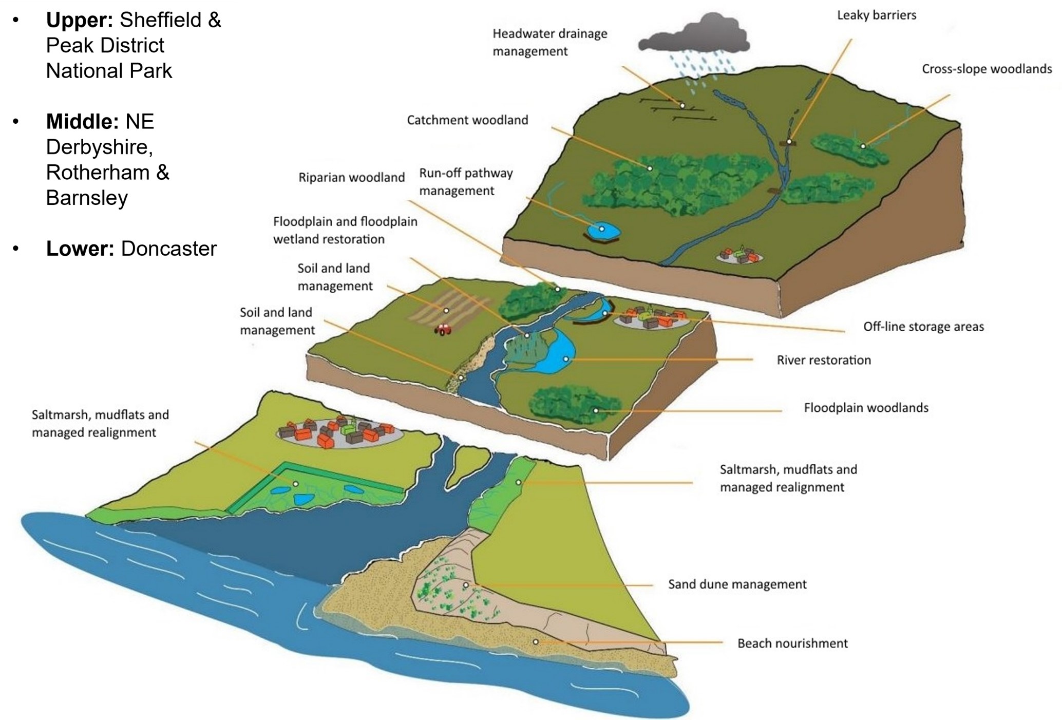
Image: Diagram showing a range of different nature-based solutions that we are considering as part of Source to Sea
In 2022, we created three new natural flood management (NFM) “demonstrator” projects in the uplands around Sheffield which aim to “slow the flow” of water into watercourses. Working in partnership with Sheffield and Rotherham Wildlife Trust, Steel Valley Project, local farmers and landowners, we have put in place lots of “leaky barriers” which hold back the flow of water and “attenuation ponds” that hold water so that it does not flow as quickly downstream.
We are also working with the Don Catchment Rivers Trust and Dearne Valley Farmers to develop natural flood management projects in Barnsley, and with farmers and landowners in the Conisborough and Tickhill areas of Doncaster.
These demonstrator sites are testing, trialling, and monitoring different ways of delivering nature-based solutions, which will in turn inform the development of the wider Source to Sea programme.
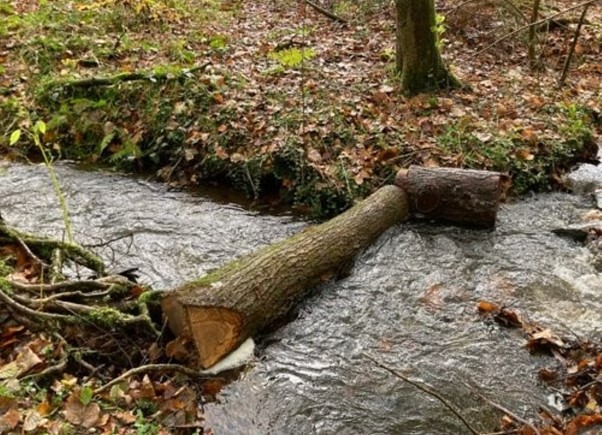
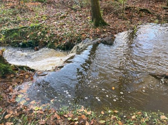
Photos: One of our natural flood management projects. A "leaky barrier" in the Limb Brook, Sheffield, showing the barrier before and after heavy rain. (Source: Sheffield and Rotherham Wildlife Trust)
Building resilience
Across the country, three in five people living in areas of flood risk do not think they are at risk of flooding.
Raising awareness and supporting families, communities and businesses to understand their flood risk and to take action is an important part of the work of Connected by Water. We work with community groups, flood wardens and schools, and attend events. Our alliance partner, the Environment Agency, manage the Environment Agency Flood Warning Service.
If you are interested in working with us, you can find out how to get in contact in the Find out more section.
What you can do to prepare for flooding and reduce risk
There are a lot of things you can do to prepare for flooding and reduce the damage flooding can cause. Here are some useful resources to help prepare yourself, your family and your home - before, during and after a flood incident.
Before a flood:
- Check your risk of flooding from rivers, surface water and reservoirs online at: www.gov.uk/check-flood-risk;
- If your property is at risk, sign up to receive warnings through the free Flood Warning Service. To register call Floodline on 0345 988 1188 or visit: www.gov.uk/sign-up-for-flood-warnings. You can receive a warning message as a phone call to your house, place of work or mobile, as well as an option to receive a text message or e-mail;
- Sign up for weather warnings from the Met Office;
- Remember, flooding can happen rapidly and away from watercourses as well as nearby.

By registering to the Flood Warning Service you will receive an advanced warning of potential flooding in your area. This gives you time to stay safe, take action and prepare yourself and your property for flooding. Even if your property is not at direct risk, roads, the rail networks you use, or your workplace might be affected.
- Create a personal flood plan, which includes a checklist of things to do to protect your family during flooding, such as turning off the electricity and gas to prevent a fire. Information can be found at: www.gov.uk/government/publications/personal-flood-plan;
- While it is impossible to completely flood-proof a property, you can make changes to your home that will help you to reduce the damage flooding can do and get back to normal more quickly after a flood. There is information in the “Prepare your property for flooding” guide: https://www.gov.uk/government/publications/prepare-your-property-for-flooding;
- Make sure you have insurance to protect your home or business. If you have buildings and contents insurance, check that flood damage is included. If you are finding it difficult to get your property insured for flooding, the National Flood Forum may be able to help: https://nationalfloodforum.org.uk/; phone number: 01299 403055;
- Become a Flood Warden volunteer by joining an existing group or forming a new group. Contact YorkshireFloodResilience@environment-agency.gov.uk to discuss.
During a flood:
- If there is an initial flood alert: prepare a bag with medicines, insurance and other important documents, and check the flood warning information service;
- If there is a subsequent confirmed flood warning: act by moving family, pets and belongings to safety, and turn off gas, water and electricity;
- Call 999 if in immediate danger;
- Follow advice from the emergency services.
Visit What to do in a flood to understand the warnings and actions to take. Further resources can be found at National Flood Forum and Know Your Flood Risk (Landmark Information Group).
Take extra care when driving:
- Check your route before you travel - roads can become quickly flooded and impassable;
- Allow plenty of time for journeys;
- Leave more space than normal between you and the car in front to allow for greater stopping distances;
- Don't attempt to drive through flood water - just 30 centimetres of flowing water is enough to float a car;
- Remember, flood water can mask hazards in the road;
- If in doubt, find another route.
After a flood:
- Flooding can be a frightening and emotional experience. How to recover after a flood offers some basic tips;
- Look after your own wellbeing and seek emotional support from charities such as the Red Cross or Samaritans. Public Health England also has Mental health advice following floods;
- Local authority webpages and contacts are a source of practical information. Also, organisations such as the National Flood Forum and Know Your Flood Risk (Landmark Information Group) can offer advice on insurance, cleaning and property resilience measures;
- There may be local initiatives you can also access. Generally, these are organised by your local authority;
- If it is possible, record and collect any evidence and data you can about the flooding and its impact. There are reviews and investigations undertaken after every incident and local information is vital in understanding the impact and where changes need to be made. This can be shared with the Environment Agency and/or local authorities.
Use water wisely
There are also things you can do all year round to use water wisely and make space for water in our drains.
- Collect water in your garden with water butts and leave more green space to absorb the water;
- Every year in Yorkshire wet wipes cause 46% of sewer blockages so 'bin it, don't block it!' (flushing wipes blocks pipes; litter blocks watercourses).
For more information about blockages visit Yorkshire Water - Help keep Yorkshire blockage free.
Find out more
For more information and news on Connected by Water you can:
 Follow us on Twitter - https://twitter.com/ConnectedbyH20
 Read our Action Plan
Contact us at: connectedbywater@environment-agency.gov.uk
This is a temporary information page.
This information page will be live for a temporary period while we develop our new Connected by Water alliance website. A link to the new website will be posted here in due course.
Audiences
- Recreational and commercial river users
- Fishing clubs and representative associations
- Members of the public with an interest in the river, the species and conservation
- Businesses
- Charities
- Statutory organisations
- NGOs
- Members of the public
- Elected representatives, including MPs
- Local councils
- Academics
- All water abstractors
- Local authorities
- District and parish councils
- Environmental bodies
- Land owners
- Farming associations
- Drainage associations
- RFCCs
- Elected representatives, including MPs
- Water companies
- Members of the public
- Recreational and commercial river users
- Community groups
- Flood action groups
- Environment Agency colleagues
- Lead Local Flood Authorities
- Local Risk Management Authorities
- Flood Resilience Forums
Interests
- Business and industry
- Flood management
- Water resources
- Water quality
- Habitats and wildlife
- Specific projects, issues, or activity pages


Share
Share on Twitter Share on Facebook