Oxford Flood Alleviation Scheme - Your Questions
Overview
- Page 1 – Welcome
- Page 2 – Background and benefits
- Page 3 – Updates and CPO Information
- Page 4 – Your Questions
Your Questions
Click on a topic below to be taken to that section.
- Environment and wildlife
- Recreation and public access
- Costs
- Construction
- Traffic
- Long term management and legacy
- Scheme design
- Flood risk
Environment and wildlife
More Information
Over time the scheme will increase the range of wildlife such as plants, insects and birds in the area – known as biodiversity. The scheme area will link up existing, high-quality wetland sites through the creation of 20 hectares of new wetland and form part of a wider valuable freshwater network throughout Oxfordshire. In addition to the creation of ponds and floodplain grazing marsh, we will also be planting 16 hectares of floodplain meadow.
Find out more about the environmental benefits we hope to achieve on Environmental features of the scheme.
More Information
Some of the environmental benefits of the scheme will be realised quickly and others will evolve more slowly over time because the different habitats that we are creating will take different lengths of time to grow and establish. We’ve made sure that we’ve taken this into account when developing the environmental design and when setting out our short-term and long-term habitat management plans.
New streams, ponds and wetlands develop into valuable habitats very quickly, so within the first few months and years of the scheme being built we would expect to see the new stream and 20 hectares of wetland habitat developing really well. These habitats will then continue to develop over time and the variety of wildlife that they support will increase. They should quickly become an environmental asset for west Oxford.
We know that newly planted woodland will take many years to grow before it develops the same ecological value as mature woodland. This is why we have designed the scheme to retain as many trees as possible. The number of new trees being planted will greatly exceed the number being felled, and the new trees will be planted and managed to create high quality woodland habitat. While the woodland is growing, it will support wildlife because developing habitats are important ecosystems in their own right.
More Information
We recognise that Hinksey Meadow is a valuable natural habitat that includes rare wildflower species and floodplain grasses. We have appointed the Floodplain Meadows Partnership (FMP) of the Open University, as national experts in MG4a grassland, to provide independent expert advice on the Hinksey Meadow. For most of the year it will look very similar to how it does now, whilst enhancing the meadow’s capacity to carry more water in times of flood. In this way the overall change to Hinksey Meadow from the new stream has been minimised as much as possible.
Recreation and public access
More Information
Some public rights of way will need to be very slightly diverted in order to avoid the new stream, flood walls and embankments. After the scheme is in place, walkers will still be able to use the public rights of way, such as Willow Walk, Electric Road, and Devil’s Backbone, as they can now. They will also be able to use the informal path from North Hinksey to the Electric Road because a footbridge will be installed over the new stream.
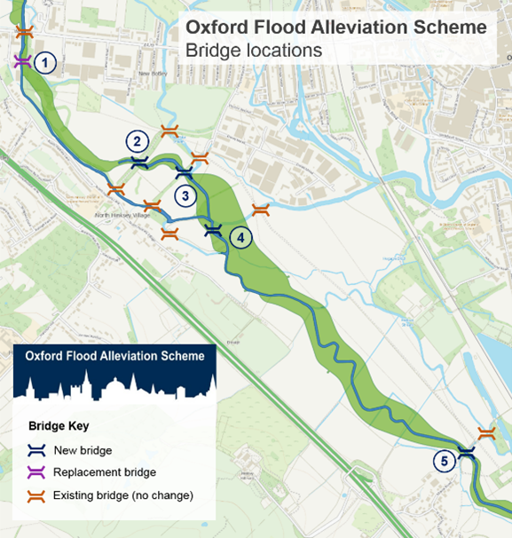
We will be creating a new track along much of the scheme to allow access for maintenance. A proportion of the track will be made into a permissive path that the public are allowed to use for walking or cycling. We are also building new bridges in the scheme area to ensure access is maintained over the new stream and wetland.
Costs
More Information
The scheme will cost around £176 million and will save £1.6 billion over its lifespan of 100 years by reducing flood damage.
Construction
More Information
We have identified a range of measures necessary to protect the environment and local communities before and during construction and once the scheme is in place. For example, minimising noise and checking air quality and traffic flow impacts. We will be installing and using temporary access tracks within the scheme area to ensure that our vehicles are not travelling too close to communities. There will be restrictions on hours of work. We will set up a community liaison process so that if any local concerns arise during construction they can be raised and addressed.
We have been in regular communication with communities particularly affected by construction plans. We have listened to their concerns and thoroughly investigated options to reduce the impact of construction as much as possible. We value the support of local communities in progressing with this vital scheme.
More Information
To preserve our cultural heritage, we have conducted archaeological investigations along the route of the flood scheme so that the scheme could be carefully designed to consider areas of archaeological interest. In 2016 we completed investigations beneath Old Abingdon Road, and the new section of the channel has been designed to avoid the culverts designated as Schedule Ancient Monuments running under the road. In 2020, we carried out archaeological investigations near to South Hinksey. This was to help determine whether one of the fields near to the village would be suitable for use as part of our construction compound. These investigations have allowed us to minimise the impact of the flood scheme on local archaeology and identify any areas where further archaeological investigations may be needed.
Traffic
More Information
We understand the effect that the movement of material could have on traffic this is a concern for local communities and businesses. We submitted a Construction Traffic Management Plan to help minimise traffic as part of the planning application.
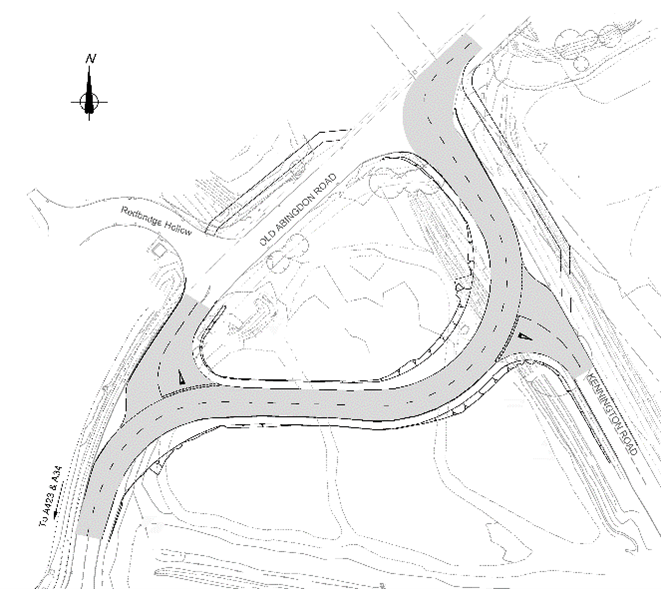
The A423 Kennington bridge in the southern end of the scheme area needs to be replaced by Oxfordshire County Council. Oxfordshire County Council will employ temporary widening and contraflow traffic management will keep vehicles flowing during the works whilst they build first one bridge and then the other. Further details of this will be available closer to construction.
The new stream will need to pass under both Old Abingdon Road and Kennington Road. To keep traffic moving we have designed a temporary road through the western side of Kendall Copse. This will allow 2-way traffic to keep flowing at all times.
Our main compound will be located in fields to the north of South Hinksey. We will construct an access road at South Hinksey to keep construction traffic away from the village itself. Lorries will leave the new compound via this access road to join the A34. We’ve been working with National Highways and the local highway authority on our proposals and discussed it with Thames Valley Police to ensure the safety of all road users. The main lorry movements will be for removal of material during the earthworks which are programmed for the summer working months, when the ground is dry. These won’t take place for the whole duration of the construction period. National Highways have suggested a speed restriction on the A34 so as part of the approvals process we’ll be submitting a Temporary Traffic Regulation Order to reduce the speed limit to 40mph on the A34.
When we begin construction, one of our first actions will be to build a temporary haul road specifically for construction traffic within the scheme area, to reduce the need for lorries to drive on local roads to access different areas of the site. We will also be submitting a separate planning application for a temporary access track to Hinksey Rail Sidings. If planning permission is granted, we will have the option of removing a significant amount of the waste material off site by rail. Agreements with the operator of Hinksey Rail Sidings will also need to be in place to enable us to remove the waste material by rail.
Long term management and legacy
More Information
The Environmental Vision is our long-term plan to support the effective management of the Oxford Flood Alleviation Scheme area. We have a detailed programme in place to maintain the scheme operationally and to establish and manage habitats for at least the next 100 years. Once we have all the necessary approvals and are nearing construction of the scheme, we will appoint an environmental partner who will lease the Environment Agency owned land once the scheme is in place. They will be responsible for looking after the wildlife and landscapes of the scheme area in the long term. They will work alongside our operational team to bring additional environmental enhancements, involve local people and community groups, establish opportunities for scientific research and visit schools to teach children about the work we do to protect and enhance the environment. Earth Trust is helping us set the foundations for this approach. They are advising us on the development of plans for how the eventual land management of the completed scheme could/should function to deliver the long term environmental, climate and human health and wellbeing benefits of the scheme. Earth Trust will develop an overarching strategy for how the scheme will benefit the environment over its lifetime. This strategy will include an environmental land management plan, and engagement with local communities and visitors. We will work collaboratively with Earth Trust for the coming years, to establish a plan for longer term engagement with scheme neighbouring landowners, communities and stakeholders to support our environmental objectives. As well as ensuring the scheme enhances the local ecosystems and habitats in the long term, ongoing maintenance will include regular tasks such as structural checks, blockage removal and grass cutting. The cost of maintenance over 100 years for both the flood scheme and surrounding landscape, including specialist habitat establishment, will come from Environment Agency budgets.
More Information
One of the ambitions of our Environmental Vision is to connect people with the scheme. School children will benefit from the specialist habitat establishment which may include nature trails within walking distance of their schools and homes. We’ll be working with the environmental charity Earth Trust on these plans to provide access and opportunities for education.
Scheme design
More Information
The only new in-stream structure is one which controls the flow in the Eastwyke Ditch, which prevents water from flowing the wrong way at different water levels.
The scheme doesn't involve new weirs, lock gates or sluices to direct flood water into the scheme. During high water levels, floodwater on the fields north of Oxford is drawn into the lowered area of ground adjacent to the Seacourt Park and Ride. This forms the start of the Oxford Flood Alleviation Scheme which allows more floodwater to move through the floodplain rather than built up areas. The benefit of this design is that it is passive and doesn't need to be actively turned on or off during floods using lock or sluice gates.
More Information
The scheme won’t affect flows upstream of the new stream. This includes on the Seacourt Stream adjacent to Hinksey Meadow. Downstream of the new stream, the Bulstake Stream and the Hinksey Stream will continue to have water in them as they do now, but during dry weather there will be less flow.
More Information
Dredging is an important part of maintenance but would not work to protect Oxford from a major flood. Even if we dredge all the rivers and streams in Oxford, it would not significantly reduce flooding from a major flood. Deepening channels around Oxford simply will not work, as excavating below the groundwater level would mean any extra space created simply fills with water. As there is barely any fall in land height over the 5km from Botley Road to Kennington, water will sit, and silt will redeposit.
If done in the wrong place, dredging can damage the environment and increase flood risk downstream. The natural tendency of all rivers after dredging is to deposit silt and return to their more natural dimensions. This means dredging is inefficient and would need constant repetition. Each repetition causes further environmental damage without ever allowing full recovery. Frequent re-dredging would also be disruptive and expensive.
More Information
We are aware that there are some alternative ideas being put forward by both individuals and groups in the community and take all these proposals seriously. We considered more than 100 combinations of options to reduce flood risk from the River Thames in Oxford, working with the community every step of the way. After careful consideration, none of the alternative proposals were considered to reduce flood levels to the same extent across the whole area as the proposed scheme, or to provide the same robust certainty and reliability of operation, or long term wider environmental enhancements.
More Information
Because flood water can stay in Oxford for days or weeks, an effective upstream storage area on its own, would need to store approximately 50 million m3 of water. This is equivalent to an area the size of Oxford 1 metre deep in water. Therefore, creating a new upstream storage area would not be a viable way to reduce flood risk to Oxford on its own, as there would not be enough capacity in the floodplain to store the amount of water required.
Flood storage options are being considered as part of our wider programme of flood risk management across the Thames Valley. The Thames Valley Flood Scheme is a catchment-wide approach to investigate ways to manage flood risk. The approaches being investigated include:
- Large scale floodwater storage in a range of locations.
- Natural flood risk management measures.
- Engineered flood risk management solutions including flood alleviation channels.
The Thames Valley Flood Scheme would also benefit Oxfordshire, as it will complement local flood alleviation schemes. More information on the Thames Valley Flood Scheme can be found here.
Flood risk
More Information
The scheme will reduce flood risk to all homes and businesses in Oxford currently at risk of flooding from the River Thames. In addition to reduced property flooding, the scheme will help keep the main railway line, Abingdon Road, Botley Road and local roads open in floods. There will be fewer flood related interruptions to essential utilities, including water, electricity, phone and internet. Schools and essential community services in flood risk areas won’t need to close during floods. Less disruption to road and rail travel around the city will help to keep Oxford open for business and support the tourist economy.
The scheme will not only lower the amount of financial damage caused by floods, it will also lessen the stress and trauma of flooding for residents and commuters, which can be devastating. Knowing that the scheme will help reduce risk during a major flood will give local people improved peace of mind from the worry of flooding.
More Information
The latest evidence from UKCIP18 climate change predictions show that flooding in the UK will become both more frequent and more severe. We have followed the latest guidance on climate change throughout the development of the Oxford Flood Alleviation Scheme. The scheme is designed to cope with a scale of flood not seen in Oxford since 1947. This is far bigger in size than any of the floods Oxford has experienced in recent decades. The Oxford Flood Alleviation Scheme will help Oxford adapt to our changing climate, ensuring the city is more resilient to face the increasing floods of coming decades.
More Information
We have ensured the scheme will not increase flood risk to properties downstream through detailed modelling. In addition, the Vale of White Horse District Council also commissioned a completely independent review of downstream impact. This was published in December 2017 and confirmed that the scheme will not increase flood risk to downstream properties, and can be found on the District Council website.
More Information
Until the scheme is completed, the Environment Agency has well-tested flood protection plans in place for Oxford, working with others, including the fire service and county council, to help those at greatest risk in the city. We encourage people to check their own flood risk and sign up for Environment Agency flood alerts.
Our contractor has taken into account the risk of flooding occurring during construction and planned the programme with this in mind – for example, we will not excavate the new stream during the winter months when flood risk is at its highest. However, floods can happen at any time and our contractor manages this risk through their flood risk plans which set out various measures to minimise the impact should this occur.
Stay in touch as the Oxford Flood Alleviation Scheme progresses:
- Email us with enquiries or sign up to receive our e-newsletters
- Follow us on social media:
Audiences
- Recreational and commercial river users
- Fishing clubs and representative associations
- Members of the public with an interest in the river, the species and conservation
- Businesses
- Charities
- Statutory organisations
- NGOs
- Members of the public
- Elected representatives, including MPs
- Local councils
- Academics
- Environment Agency customers
- Environment Agency colleagues
Interests
- Flood management
- Habitats and wildlife
- Specific projects, issues, or activity pages
Share
Share on Twitter Share on Facebook