Oxford Flood Alleviation Scheme - Background and benefits
Overview
- Page 1 – Welcome
- Page 2 – Background and benefits
- Page 3 – Updates and CPO Information
- Page 4 – Your Questions
On this page we provide information about the Oxford Flood Alleviation Scheme, including the scheme design, benefits and environmental features.
Please click on each of the headings below to find out more.
More Information
Flooding in Oxford
Oxford has a long history of flooding. Significant floods in past decades have caused property damage to homes and businesses and closed the railway and major roads, bringing the city to a standstill. Since 2000 there have been 7 floods that caused property flooding. For those that experienced the floods of 2003, 2007 or 2013/2014, the disruption will be memorable. Floodwater cut off Botley and Abingdon Roads, closed the railway line and caused devastation to many homes and businesses.
Recent high river flows in 2020 and 2021 were a reminder of how vulnerable many homes are, with floodwater kept at bay by temporary barriers and pumps. These floods of recent decades have been nowhere near the scale we expect in coming years due to climate change. It is only a matter of time before Oxford again sees a major flood, of a size last experienced in 1947.
Recent floods in and around Oxford
What we do now
Throughout the year, the Environment Agency maintains rivers and streams and operates weirs in and around Oxford. This work reduces flood risk in Oxford from smaller, more regular floods, but more significant flooding cannot be reduced by maintenance alone.
Our Environment Agency incident teams also respond to flooding, including sending alerts to homes and businesses, working with emergency response partners and using temporary barriers and pumps when necessary. The current temporary barriers used in places such as South Hinksey village are not adequate to withstand the major floods that are increasingly likely.
Climate change
With climate change, flooding in the UK will become both more frequent and more severe. In the face of this increasing flood risk, the scheme is designed to cope with major floods of a scale Oxford last experienced in 1947. The scheme will provide a long term, sustainable solution to manage flooding in Oxford for the next 100 years.
More Information
The scheme will benefit everyone who lives, works in or visits Oxford. As well as reducing flood risk, we are creating a setting in which plants and wildlife can thrive and will offer opportunities to enrich the education and wellbeing of local communities.
Reduced flood risk
The scheme will reduce flood risk to all homes and businesses in Oxford currently at risk of flooding from the River Thames. Not only does this lower the amount of financial damage caused by flooding it also lessens the stress and mental impact of flooding, which can be devastating to communities. Even if your property is not directly at risk, you will benefit from fewer flood related interruptions to essential utilities, including water, electricity, phone, and internet. Schools and community services in flood risk areas won’t need to close during floods. There will be less disruption to road and rail travel around the city which will help to keep Oxford open for business and support the tourist economy. Having the scheme in place will avoid £1.5 billion by reducing flood damage and impact on the city over 100 years.
Map showing reduction in flood risk after the scheme is in place
Enjoyment of the landscape
Our aim is that the new wetland and wildlife this will attract will further enhance the enjoyment of the area. We will be creating a new track along much of the scheme to allow access for maintenance. A proportion of the track will be made into a permissive path that the public will be able to use for cycling and walking, increasing recreation opportunities in the area.
Environmental benefits
The scheme will bring additional environmental benefits to the area, which are covered in more detail below.
More Information
The map below shows the location and main features of the scheme.

How was this design chosen?
After the 2007 floods, we developed the Oxford Flood Risk Management Strategy which looked at over 100 different combinations of options to reduce flood risk in Oxford. The strategy recommended a 3-stage approach to reducing flood risk in Oxford in the short, medium and long term.
- Short term - Provide temporary measures, such as temporary flood barriers and supporting communities with preparing for floods. Measures completed in 2014 included localised desilting, new culvert works and temporary defences.
- Medium term - The Oxford Flood Alleviation Scheme as it is currently being developed. This is to create more space for floodwater away from built-up areas.
- Long term - Upstream floodwater storage options to help further tackle the increasing flood risk due to climate change. Upstream storage in a range of locations is being explored by the Environment Agency as part of the Thames Valley Flood Scheme.
How does the scheme fit with the Thames Valley Flood Scheme?
The Environment Agency is in the early stages of developing the Thames Valley Flood Scheme to manage flood risk on a catchment scale, across the wider Thames Valley area. This would also benefit Oxfordshire. The scheme is considering a range of approaches to manage the future increased flood risk that climate change will bring. The intention is that this catchment scale approach will complement local flood alleviation schemes.
For more information on the Thames Valley Flood Scheme: Thames Valley Flood Scheme.
How will the scheme work?
Watch our video on how the scheme works here.
The Oxford Flood Alleviation Scheme will work to reduce flood risk by creating more space for floodwater away from built-up areas. The scheme will create:
- a new stream - this will always carry water
- a lowered floodplain of wetland and grazing meadow alongside the new stream – most of the time this won’t carry water
When water levels in the River Thames and other existing streams are high, water will overflow from the new stream and start to fill the lowered floodplain next to it. The scheme does not need to be turned ‘on’ or ‘off’ when floods occur - water will simply enter the lowered floodplain as river levels rise. This draws floodwater away from built-up areas that would otherwise flood. In major floods water will still also use the wider existing floodplain, which is mostly farmland and flood meadow. In this way the scheme is designed to work together with the natural floodplain.
The new stream with lowered floodplain is integral to the working of the flood scheme so that flood risk is reduced adequately and not transferred elsewhere. The lowered ground alongside the new stream will provide more capacity for floodwater and a defined route for this to move through the floodplain. This ensures additional floodwater entering the system at Seacourt Bridge on the Botley Road will follow the best possible route as it passes through the floodplain, away from communities. It will provide this benefit throughout a range of different sizes of floods, as the lowered ground does not store static water but provides additional space for it to flow through, even when the existing floodplain starts to fill, moving water efficiently through the system and away from properties and businesses.
We have ensured the scheme will not increase flood risk to properties downstream. As well as our own detailed modelling, this has been independently confirmed by the Vale of White Horse District Council.
What will the Oxford Flood Alleviation Scheme look like?
The scheme has been sensitively designed to integrate with the existing landscape. The new stream will look and behave like a natural stream, with grazing pasture and wetland alongside it. It will have pools where the water is deeper and flows slowly, and gravel riffles where the water is shallower and flows quickly. The stream will typically be around 8 metres wide, with this width varying to give the type of profile that occurs naturally, being up to 15 metres wide in some locations. The new stream will connect with the existing stream network, including the Seacourt Stream, Bulstake Stream and Hinksey Stream, and will meander through the floodplain to re-join the River Thames.
The ground alongside the new stream will be lowered by around 1 metre from existing ground levels, with a gradual incline at the edges back up to the original ground level. This will create a gently sloping floodplain which will be seeded with grass and wildflowers and include an extensive network of freshwater features including ponds, scrapes and backwaters. This lowered ground next to the new stream will only hold floodwater when river levels are sufficiently high. This may occur regularly during wetter periods, especially during the winter months.
Hedgerow, trees and woodland will be planted, and floodplain meadows will be created outside the lowered area to retain a green floodplain corridor, joining up existing important wetland habitats. The pattern of fields and hedgerows will be altered slightly to accommodate the new stream and lowered floodplain but the overall character of riverside vegetation with small woodland blocks and larger fields will remain the same. Wherever possible existing vegetation is being kept in order to integrate the scheme into the existing landscape to the greatest extent possible.
The scheme keeps hard engineering to a minimum, but some structures will be built to complement the new stream where needed, including:
- New bridges for footpaths and bridleways to cross the new stream.
- Culverts for water to pass under main roads in the south of the scheme.
- Earth embankments and flood walls in some places to reduce risk to houses which would otherwise still flood.
For further technical details, check out our planning application documents on the Oxfordshire County Council planning portal.
Bridges and footpaths
We are building new bridges in the scheme area to ensure access is maintained over the new stream. These are shown on the map below and include:
- Replacing the existing Westway Cycle Bridge which crosses Seacourt Stream at the north end of the scheme. We will replace this in the same timber style as present but with an increased span. (1)
- A new bridge at Willow Walk which will be suitable for pedestrians, cyclists and horses. This will replace the existing culverts and their metal railings. (2)
- A new footbridge with wooden decking at North Hinksey along North Hinksey Causeway. (3)
- A new footbridge with wooden decking so people can continue to walk from behind the Fishes pub across the new stream and wetland. (4)
- A new bridge at Devil’s Backbone, which will be designed to meet cycleway standards. This will provide an opportunity for the Devil's Backbone path to be upgraded to a cycleway in the future. (5)
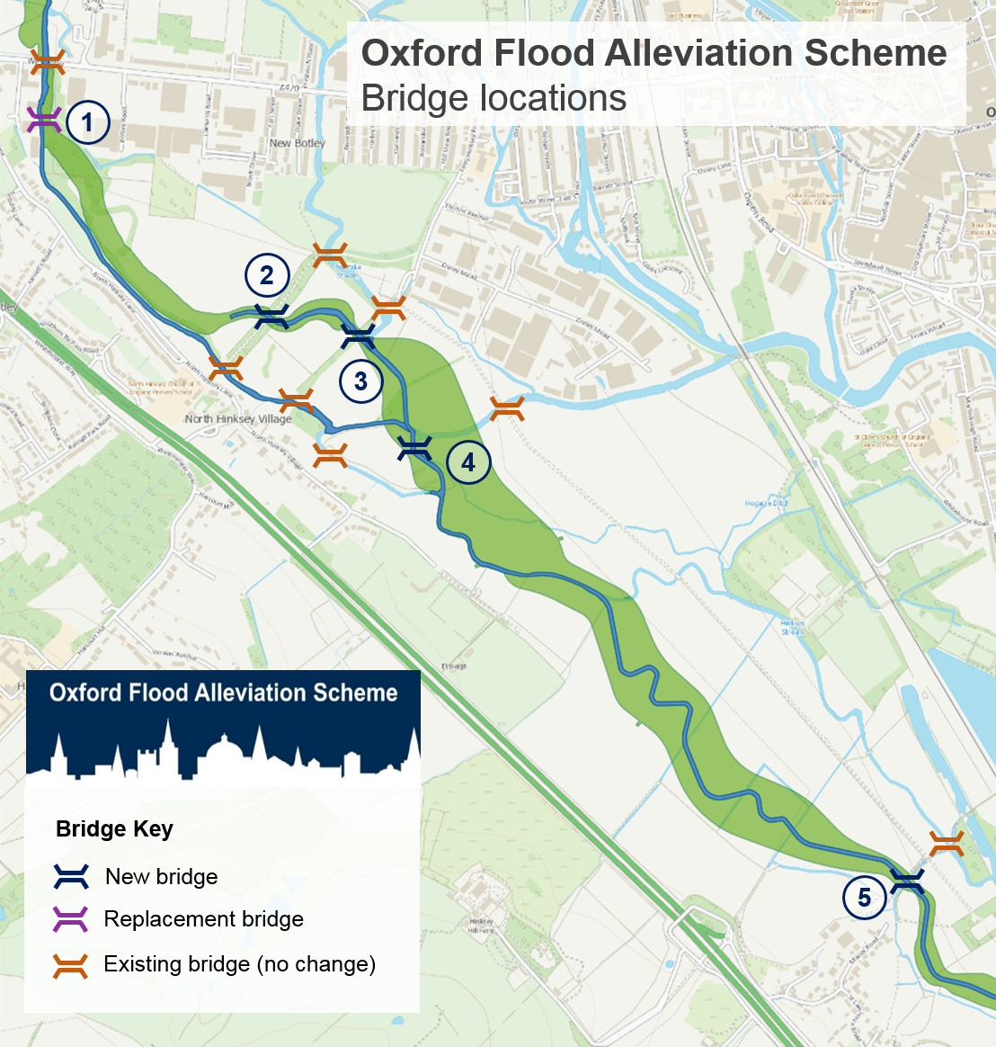
Willow Walk will remain as a bridleway. The new bridge will continue from the existing track, just raised slightly higher. It replaces the existing culverts to allow for the larger volume of water that will pass under Willow Walk in a major flood. The existing stone arch bridge at Willow Walk will remain as it is and normal river flows will continue under this at all times.

Visualisation of the scheme looking towards Willow Walk Bridge from Hinksey Meadow
While we carry out this work we are proposing to put in a temporary raised walkway running alongside Willow Walk. This temporary raised walkway will be suitable for pedestrians, cyclists and horses. Once construction is complete we will plant 20 white willows - 10 on each side of the path - to reinstate the avenue of trees. We are working with Oxford City Council Direct Services to develop a long-term maintenance plan for Willow Walk with the aim of enhancing this important landscape feature in the long term. Our tree-planting proposals will reflect this arrangement.
While we’re building the scheme we will create a temporary path along the boundary of Seacourt Nature Park to maintain access between Botley Road and Hinksey Meadows. Once the scheme is built people will still be able to visit and enjoy Seacourt Nature Park.
There will be some other temporary closures of designated bridleway, footpaths and cycleways while we build the scheme. We will always signpost alternative routes and put in temporary routes where possible.
More Information
The Oxford Flood Alleviation Scheme provides a unique opportunity to not only help protect Oxford from flooding but to create a wetland wildlife corridor. This will form part of a wider valuable freshwater network throughout Oxfordshire, linking with existing wildlife sites.
Biodiversity
Over time the scheme will increase the range of wildlife such as plants, insects and birds in the area – known as biodiversity.
New stream and wetland
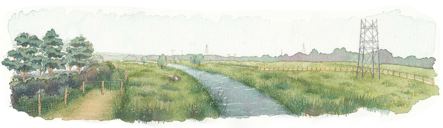
Impression of the new stream, viewed from Devil's Backbone
The new stream will carry flowing water all the time. It will include shallower sections and pools, with varied speeds and depths to create high quality habitat. We will plant native trees and shrubs close to the stream in order to provide pockets of shaded habitat. These areas of tree and shrub planting have been carefully designed so that they will not restrict flows but will increase biodiversity and complement the existing landscape.
The ground alongside the new stream will be lowered to create a sloping floodplain with an extensive network of freshwater features including ponds, scrapes and backwaters. The area will be sown with wetland meadow grass and wildflower seed mixes. Periodic flooding, together with the damper ground next to the new stream, will support around 20 hectares of floodplain grassland. Floodplain grassland sites typically support rarer bird species such as lapwing, yellow wagtail and snipe. The ponds and scrapes will also increase the diversity of plants and invertebrates in the area.
Reducing our carbon footprint
The scheme has been designed so that it will require little active management and maintenance. The new stream will operate with minimal intervention and the lowered floodplain can be maintained largely through traditional land management techniques that are appropriate to the site. Sustainable features include:
- A natural looking stream, avoiding hard engineering where possible.
- Re-using the majority of the gravels excavated within the scheme area to create the bed of the new stream and to improve the habitat within existing streams.
- Where space allows, we are re-using earth excavated within the scheme area to create flood embankments rather than walls.
- Nothing in the scheme requires the operation of machinery which would produce emissions. There are no permanent pumps or pipes to manage river floodwaters. Manufacturing pumps and pipes is very energy intensive, and they would also require regular maintenance and replacement.
- The lowered ground next to the new stream will be grazed by a very small herd of cattle in the summer meaning that mechanical cuts will only be undertaken when necessary to keep down woody growth that the cattle will not eat.
We are regularly reviewing how we can further reduce our carbon footprint in constructing and maintaining the scheme as much as possible. Sustainable or low carbon materials will be specified where possible. This will include lower carbon concrete as standard.
Most of our carbon emissions will be from machinery and vehicles needed to move material and from producing the concrete and steel we will use. We continue to explore ways to reduce the carbon generated through construction and maintenance, including how we might use current and future technology. Our carbon forecast for the future operation and maintenance of the scheme after construction is presented in our new planning application.
Building the Oxford Flood Alleviation Scheme will reduce the likelihood of floods in built-up areas. Flooding causes carbon emissions due to direct damage and disruption, as well as the replacement and refurbishment of properties, vehicles, and belongings. Once the Oxford Scheme is in place, it will prevent the production of far more carbon emissions in the long term than are generated through its construction and maintenance.
Trees and hedgerows
Our planting proposals will result in more trees within the area after completion than there currently are at present.
While designing the scheme, engineers, landscape architects and ecologists have worked together to minimise the loss of existing habitat and landscape features including woodland, trees and hedgerows, and to maximise environmental gain. Our proposals will integrate with the existing landscape to the greatest extent possible. An Environmental Clerk of Works will be on site and work alongside the contractor to make sure that all opportunities to preserve existing habitats are identified and taken wherever possible.
We plan to plant over 4000 trees within areas of proposed woodland. In addition, thousands of smaller trees, such as hawthorn, hazel and elder, will also be planted within the proposed woodland areas and on the woodland edges, along with many more native shrubs such as dogwood, goat willow, dog rose and wild privet. Around 2000 trees will be felled. Areas of deciduous woodland and lengths of hedgerow will be planted close to where habitats need to be removed in order to maintain a corridor of tree and shrub cover. The scale and orientation of the woodland and hedgerow planting will match the existing landscape character. Only small groups of trees will be planted in the lowered floodplain beside the new stream because planting woodland and hedgerows here would impede the flow of floodwater.
The woodland areas will be managed for wildlife through traditional techniques such as coppicing which allows light to reach the woodland floor and encourages a diverse ground flora. The woodland areas will also include glades that are sown with wildflowers to encourage butterflies and other insects, as well as birds and foraging bats. This is in contrast to the majority of the existing woodland where the unmanaged, single age mature trees support only sparse shade-tolerant ground flora. The replacement woodland trees will be saplings and it will be many years before they have the same ecological value as those being felled. This is being taken into account when calculating biodiversity net gain.
New species-rich hedgerow will be planted throughout the scheme area and additional hedgerow planting will be carried out off-site to ensure a net gain in this habitat. We will create the new hedgerows using plants grown from locally sourced seeds and self-seeded shrubs and trees and hedgerow species. These will provide a range of flowering and fruiting times.
Grassland and floodplain meadow
We are taking measures to preserve the existing rare grassland found in the scheme area as much as possible and will be creating around 16 hectares of new floodplain meadow, with a rich variety of plant species.
Hinksey Meadow is designated as a Local Wildlife Site and includes areas of rare floodplain meadow called MG4 grassland. Sites supporting MG4 grassland are usually managed as traditional hay meadows, with a hay crop cut in mid-summer followed by autumn grazing. MG4 grassland is scarce across the UK because traditional hay meadows have been drained or converted to other land uses.
The scheme will involve lowering the ground on the western edge of Hinksey Meadow, next to the Seacourt Stream. We appointed the Floodplain Meadows Partnership (FMP) of the Open University, as national experts in MG4 grassland, to provide independent expert advice on how best to preserve the meadow and provide replacement meadow where some loss is unavoidable.
- We will keep the lowered ground adjacent to Seacourt Stream narrower here and route it to avoid the MG4 as much as possible. The upper part of the slope will be seeded with MG4.
- There will be an unavoidable loss of approximately 2 hectares of MG4 grassland. We’ll create around 16 hectares of new species-rich floodplain meadow nearby. We’ll use a tried and tested meadow establishment technique to do this, which involves lightly cutting up the soil in the existing grassland and spreading seeds or freshly cut hay over it to increase the range of species. The seeds and hay will be collected from existing MG4 meadows nearby.
- We will maintain current groundwater levels in Hinksey Meadow by managing water levels in the Bulstake and Seacourt Streams.
- We’ll carefully lift the MG4 turf which needs to be dug up and take it to a site with similar soil and ground conditions to Hinksey Meadow, where it will be managed as hay meadow. We acknowledge there’s a high chance this translocation will not be fully successful and so have ensured the other proposals will ensure an overall gain in floodplain meadow even if the relocated turf doesn’t survive.
Both during and after construction, it will still be possible for MG4 in Hinksey Meadow to have a hay cut in the summer and then to be grazed afterwards, as it is currently. Removable fencing can be used to allow seasonal cattle grazing to continue as appropriate.
More Information
Construction
If planning is approved construction will start from the north and we anticipate it will take 3 years to complete the areas north of Old Abingdon Road. We can begin building the southern part of the scheme once Oxfordshire County Council have completed the replacement A423 Kennington Railway Bridge. For more information on the A423 bridge, please refer to the Oxfordshire County Council website.
One of the main tasks in building the scheme will be to remove a large amount of material such as earth and gravel from the floodplain to create space for floodwater. We will re-use much of the excavated material on site, for example in earth embankments and environmental features, and we’ll retain some topsoil to help vegetation recover after construction. We will still need to transport around 365,000m³ of material out of the area. We cannot leave it in the floodplain, so it will be moved off site to be used for landscape restoration in previously excavated quarries.
To complete this important task we need a temporary compound in the area and close to transport links while the scheme is being built. The compound will be removed following completion of the scheme. Due to the nature of the scheme area, which is bordered by the A34 to the west and mainline railway to the east, and in the floodplain, the location for this main compound will be in fields close to South Hinksey.
We will need an additional temporary compound in the south of the scheme for our work near Kennington, where the new stream needs to be excavated below main roads. This temporary compound will be located in the western part of Kendall Copse, and we will need to use a small area of Redbridge Park & Ride for some specific tasks, such as drying out excavated material. The map below shows the intended locations of our 3 main construction compounds.
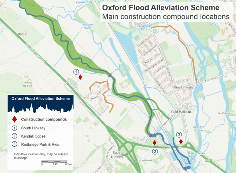
The proposed replacement of the A423 bridge has changed where the new stream will pass underneath the A423. As the new stream now passes much closer to the railway, we also need to realign the channel through Kendall Copse to avoid tight bends for the water here. The new stream will now pass more centrally through the eastern part of Kendall Copse. This will improve river flows during floods, and retains some of the mature trees in the north east corner of Kendall Copse next to the railway line. It will keep the works further from the ancient culverts that were part of a medieval causeway under the Old Abingdon Road, removing the need to reinforce the bank next to these scheduled ancient monuments.
Building the scheme considerately
We have identified a range of measures necessary to protect the environment and local communities before and during construction and once the scheme is in place. For example, minimising noise and checking air quality and traffic flow impacts. We use a process called Environmental Impact Assessment (EIA) to identify and detail these. They are then incorporated into the contractor’s contract by means of an Environmental Action Plan (EAP). This is submitted in the planning application as an appendix to the Environmental Statement, but it is a live document we continue to develop. It will be updated as design details are finalised and as construction progresses. The Environmental Action Plan includes a number of separate plans for specific areas of work, for example a Construction Traffic Management Plan and a Site Waste Management Plan. It also sets out the measures that must be taken to protect all other parts of the environment covered by the Environmental Impact Assessment.
We will be installing and using temporary access tracks within the scheme area to ensure that our vehicles are not travelling too close to communities. There will be restrictions on hours of work. We will set up a community liaison process so that if any local concerns arise during construction they can be raised and addressed.
We have been in regular communication with communities particularly affected by construction plans. We have listened to their concerns and thoroughly investigated options to reduce the impact of construction as much as possible. We value the support of local communities in progressing with this vital scheme. Please don’t hesitate to contact us if you have any questions: oxfordscheme@environment-agency.gov.uk.
Stay in touch
Stay in touch as the Oxford Flood Alleviation Scheme progresses:
- Email us with enquiries or sign up to receive our e-newsletters
- Follow us on social media:
Audiences
- Recreational and commercial river users
- Fishing clubs and representative associations
- Members of the public with an interest in the river, the species and conservation
- Businesses
- Charities
- Statutory organisations
- NGOs
- Members of the public
- Elected representatives, including MPs
- Local councils
- Academics
- Environment Agency customers
- Environment Agency colleagues
Interests
- Flood management
- Habitats and wildlife
- Specific projects, issues, or activity pages
Share
Share on Twitter Share on Facebook