
Yaverland Coastal Defence Scheme Information Page
Overview
Welcome to the Yaverland Coastal Defence Scheme Information Page.
Fantastic turnout at community information event this week
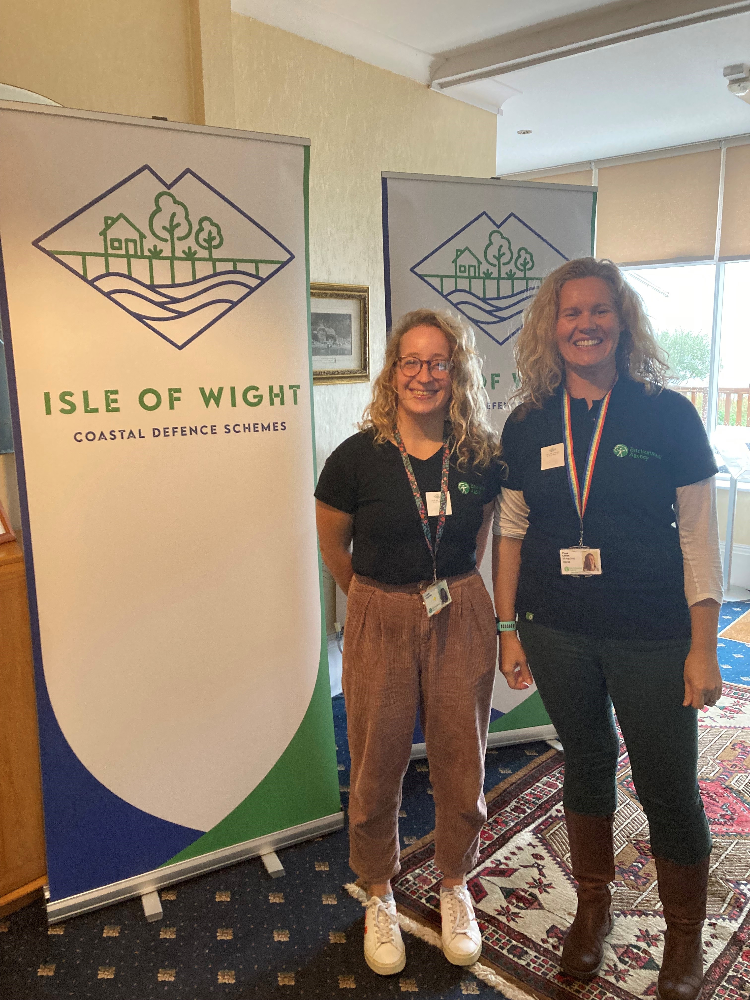
Thank you to everyone who attended our community information event at Browns Golf & PLUTO'S Café on Tuesday 18 February. We had a great turnout and spoke to many members of the community about the inital design for the scheme. At the event we presented artists illustrations showing what the scheme might look like and what might happen during construction. We explained how the scheme will better protect 168 homes and 118 businesses from coastal erosion and flooding.
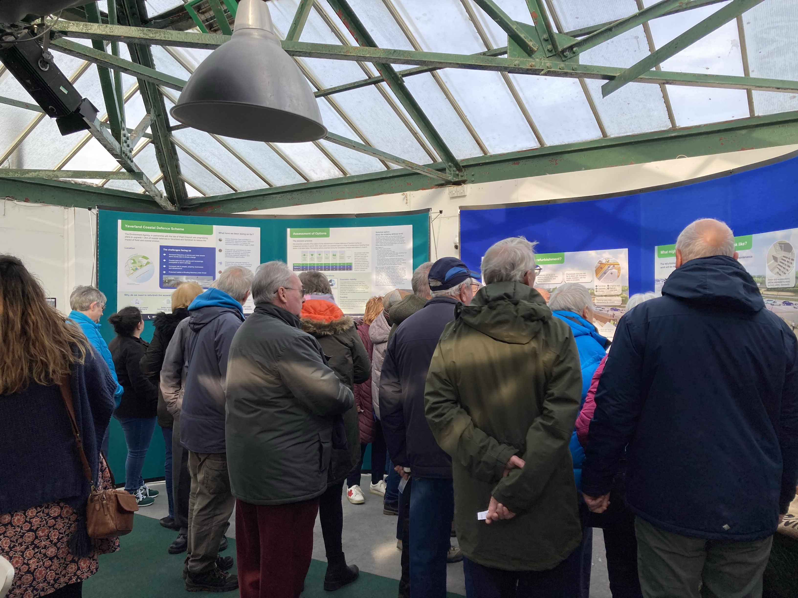
The posters displayed at the event can be viewed here:
Poster 1: The need for the scheme
Poster 2: Assessment of options
Poster 3: What improvements would you like to see?
Poster 4: What might happen during the refurbishment?
Poster 5: What might a coastal defence refurbishment look like?
Our next event is an online presentation from the project team where we will talk through the posters in more detail and answer questions.
Upcoming events:
Yaverland Coastal Defence Scheme Online Presentation | Monday 10 March | 6:30pm – 8:00pm
Register for this event here:
Sign up to receive our newsletter and important project updates
If you would like to be added to our mailing list to receive updates on this project or any other of the Isle of Wight coastal defence projects, please email us and let us know which projects you are interested in. Our email address is: IOW_FDschemes@environment-agency.gov.uk
Register your interest to join our Sandown Bay community working group
If you would like to register your interest to participate in or present to the Sandown Bay community working group for the Shanklin and Yaverland Coastal Defence Schemes, please email us and let us know which projects you are interested in. Our email address is: IOW_FDschemes@environment-agency.gov.uk
Latest update: 04 February 2025
Shanklin & Yaverland Coastal Defence Update – Exciting Progress for Our Community!
We’re starting 2025 with fantastic news! The Shanklin and Yaverland Coastal Defence Schemes have taken a major step forward, bringing us closer to better protecting our beautiful coastline and the homes, businesses, and infrastructure that rely on it. Thanks to strong support and a well-evidenced case, we have secured over £4 million in central government funding to move to the next stage: developing a Full Business Case (FBC).
Why This Matters
Coastal erosion and flooding have long been concerns for our community. This scheme is designed to safeguard over 500 properties and businesses, ensuring a more resilient and sustainable future for Sandown Bay. By strengthening sea walls, reinforcing foundations, and maintaining beach stability, we’re helping to protect the coastline for future generations while preserving the stunning views and natural beauty we all cherish.
Key Updates
✅ Funding Boost – Over £4 million secured for the next stage, with further funding strategies being explored.
✅ Stronger Protections – Plans to reinforce the sea wall and enhance beach stability through carefully designed defences.
✅ Carbon Conscious Approach – The project will use low-carbon materials and sustainable maintenance methods.
✅ Public Consultation – Your input is essential! Designs will incorporate community feedback, and we’re looking forward to hearing your thoughts.
Upcoming Events – Have Your Say!
To keep you informed and involved, we’re hosting community engagement events in February. These are great opportunities to meet the project team, view initial design plans, and share your thoughts.
Tuesday 18 February | 2:00pm - 6:30pm | Browns Golf & PLUTO’s Café, Sandown
Wednesday 19 February | 10:30am - 3:00pm | Shanklin Sandown Rowing Club, Shanklin
Come along to learn more, ask questions, and see an artist’s interpretation of the proposed designs!
What’s Next?
Finalising Designs – Detailed designs, including sea wall finishes and pedestrian railings, will be shaped in 2025.
Construction Timeline – If all goes to plan, work is expected to begin in Spring 2026, with completion by early 2028.
Preserving Our Bay – The scheme will maintain the uninterrupted coastal views we all love, while also ensuring long-term protection.
This is an exciting time for our coastal community, and we want everyone to feel part of this journey. Whether you’re a resident, business owner, or visitor, your support and input are invaluable in shaping the future of Sandown Bay.
If you have any questions, or want to learn more, come along to our events or email IOW_FDschemes@environment-agency.gov.uk.
Thank you for being part of this vital project – together, we’re making our coastline stronger, safer, and better for generations to come!
The Shanklin & Yaverland Coastal Defence Team
Latest update: 08 August 2024
We are currently writing the Outline Business Case for the scheme. This will make the case for investment and unlock funding to proceed to the final business case stage (Full Business Case). The design for the refurbishment work will be developed in more detail during Full Business Case stage. We expect this investment decision to be made by the end of 2024. We will hold further community information events once this investment decision is made. Sign up to our newsletter to ensure you are notified of future community information events.
Update: 01 August 2024
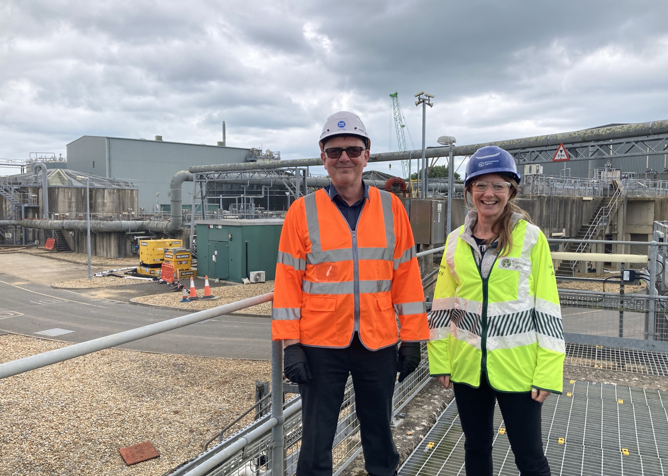
Our team visited Sandown Wastewater Treatment Works last week. The site is at risk of flooding from the sea if the Yaverland coastal defences were to fail. The site could be inundated by around 50cm of flood water. Southern Water showed us the site to help us understand what equipment is at risk of flooding and the associated impacts to their customers.
Understanding the potential impacts of flooding at the site will help us to attract additional funding for the refurbishment work and build a stronger case for investing in the coastal defences. The Yaverland Coastal Defence scheme will better protect this critical infrastructure from the risk of flooding from the sea for 50 years.
Update: 22 May 2024
Update: 28 March 2024
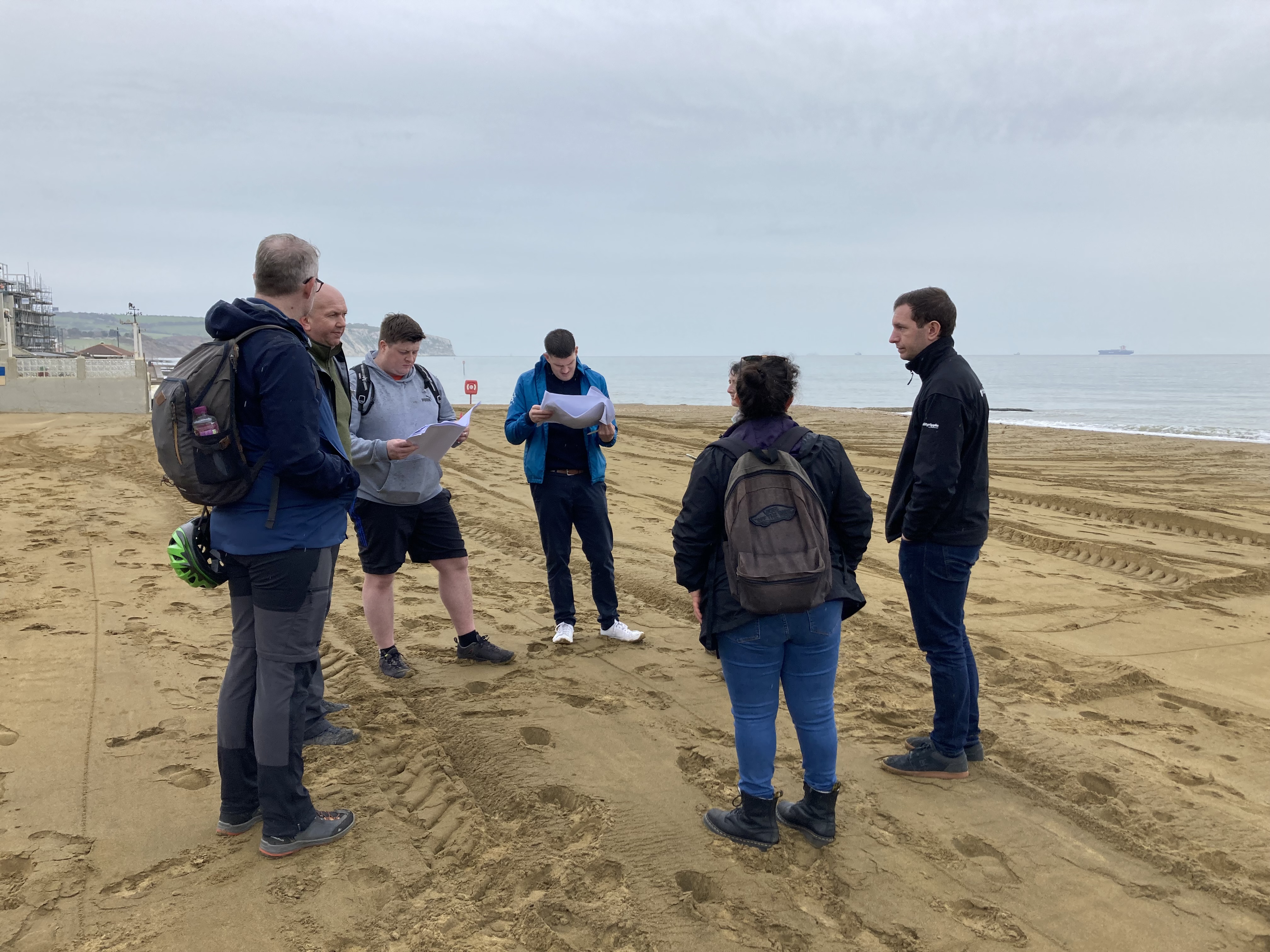
Members of the project team visited Yaverland and Shanklin this week to review the draft engineering designs and allow our estimator to update the project construction costs. Opportunities to improve the design and increase efficiency of the construction work were identified.
Preferred option announced: 18 March 2024
Our latest newsletter can be viewed below.
Your browser does not support inline PDF viewing. Please download the PDF.
A copy of the March 2024 newsletter can be downloaded here.
Design work to progress on option chosen to refurbish the coastal defences
The coastal defences will continue to reduce the risk of coastal erosion and flooding to the Yaverland and Sandown area for 50 years to come following a decision by Isle of Wight Council on the best way forward. The decision to refurbish the coastal defences was made following review of a series of ground investigative works, financial analysis and flood risk assessments. The public consultation told us that better protection from coastal erosion and flooding is important locally. The scheme will provide over £160 million worth of benefits to people, property and the environment. The project team will now draw up an initial design and establish a construction methodology for the refurbishment work.
A reminder of the short list of options
In November 2023 we were pleased to hold public exhibitions to showcase the short list of options for refurbishing the coastal defences.
We produced the following information for our public exhibitions to help explain what the scheme is about and how we arrived at our short list of options:
Exhibition banner 1 - Introduction
Exhibition Banner 2 - Scheme extent
Exhibition Poster 1 - Survey and Investigations
Exhibition Poster 2 - Constraints and Opportunities
Exhibition Poster 3 - Measures considered
Exhibition Poster 4 - Project objectives and criteria
Exhibition Poster 5 - Short List
The short list of options being considered were:
Option 1: Do Nothing
Option 2: Do Minimum
Option 3: Keep the existing defence level
Option 4: Raise the level of the defence in stages into the future
Option 5: Raise the defence level now
Preferred Option: Option 3 (keep the existing defence level)
Option 3 (Keep the existing defence level) has been chosen by Isle of Wight Council as the preferred way forward following a recommendation made by the Environment Agency.
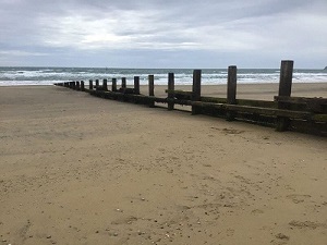
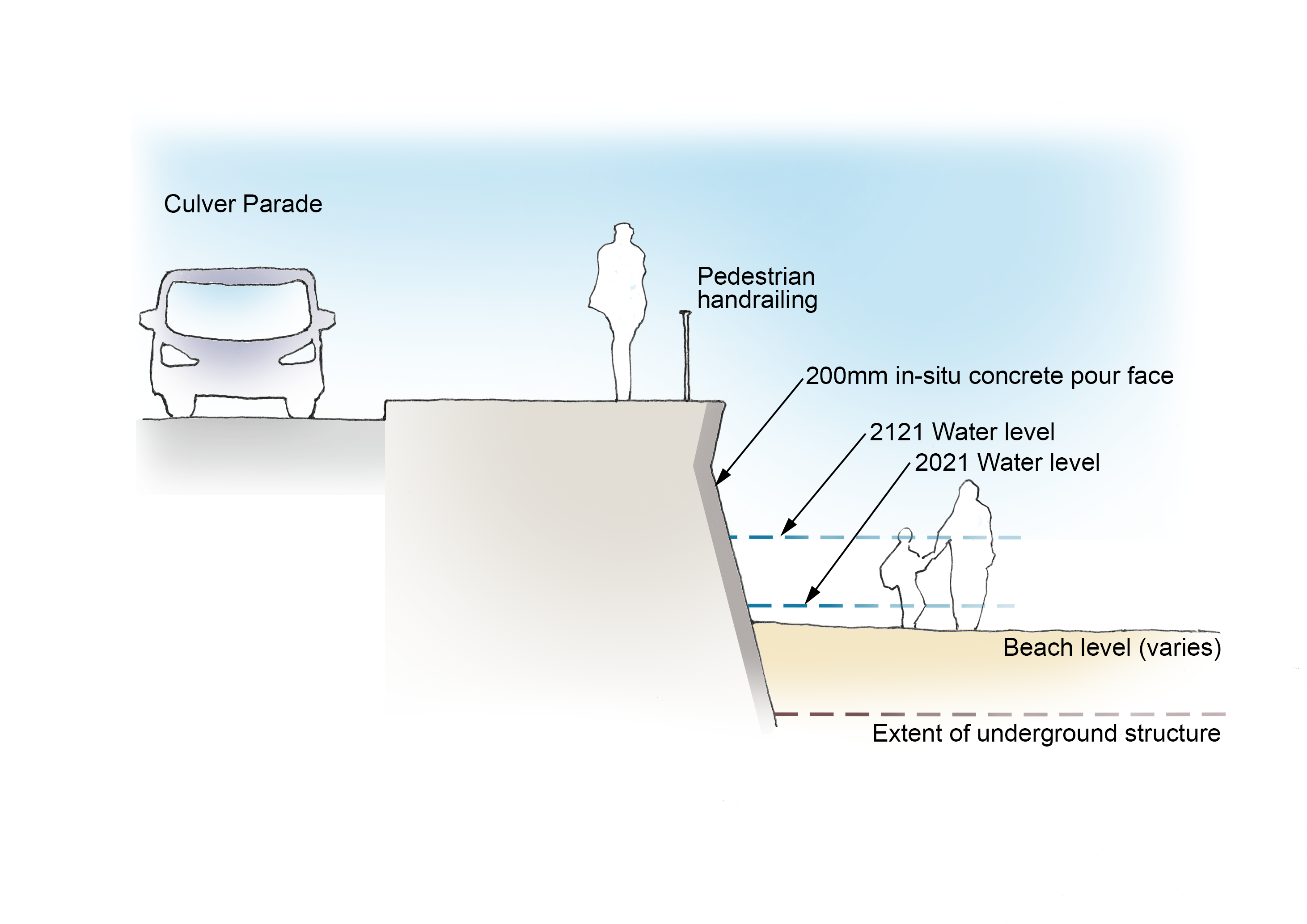 Option 3 will involve construction works to refurbish the sea wall and timber and concrete groynes. The methodology for refurbishment will be confirmed during the next stage as the team progress with drawing up an initial design. The current thinking is that works to the walls will be constructed using shutters and in-situ pour of concrete 200mm against the face of the existing sea wall. This option will provide a quality finish. Temporary works such as sheet piling will be required along the section of wall and groyne being worked on to provide a safe and dry working corridor.
The defence level will be kept at the existing level. No raising of the existing defence height will be made over the next 50 years. As part of the refurbishment project, we will include works which strengthen the foundations of the seawall with the foresight that a decision to raise the height of the seawall may be a viable option in 50 years’ time.
How was the preferred option selected?
An overview of the options appraisal process at Outline Business Case stage is presented in the poster below:
Exhibition Banner 2 - Scheme extent
Continue reading for more detail about the process
The Preferred Option has been selected using the decision-making process defined in the Flood and Coastal Erosion Risk Management Appraisal Guidance. For this type of project, Cost Benefit Analysis has been used to select the Preferred Option in accordance with the appraisal guidance. This guidance defines Cost Benefit Analysis as a type of appraisal or assessment which compares benefits and costs to identify the impact of different options on overall welfare.
The project objectives were split into criteria to allow the objectives to be assessed in more detail. Elected councillors were invited to participate in the process for assessing whether the options met broader Isle of Wight Council objectives. This exercise allowed the options to be ranked in order of acceptance.
The engineering implications of the options were assessed following a review of the Ground Investigation Report by the geotechnical and structural engineers. The carbon footprint for the short list of options was quantified and a high-level construction cost estimated. This is in addition to overtopping and inundation flood modelling, further environmental and Biodiversity Net Gain assessments, detailed economic appraisals and funding assessments which have also been carried out.
With the results of the appraisal and public consultation to hand, the project team were joined by Isle of Wight Council representatives at a workshop on 30 November 2023 to agree the preferred option. This recommendation was then reviewed by Isle of Wight Council’s Climate and Environment Board for consideration. The recommendation received approval with the stipulation that the design must not preclude a decision to raise the height of the seawall in the future.
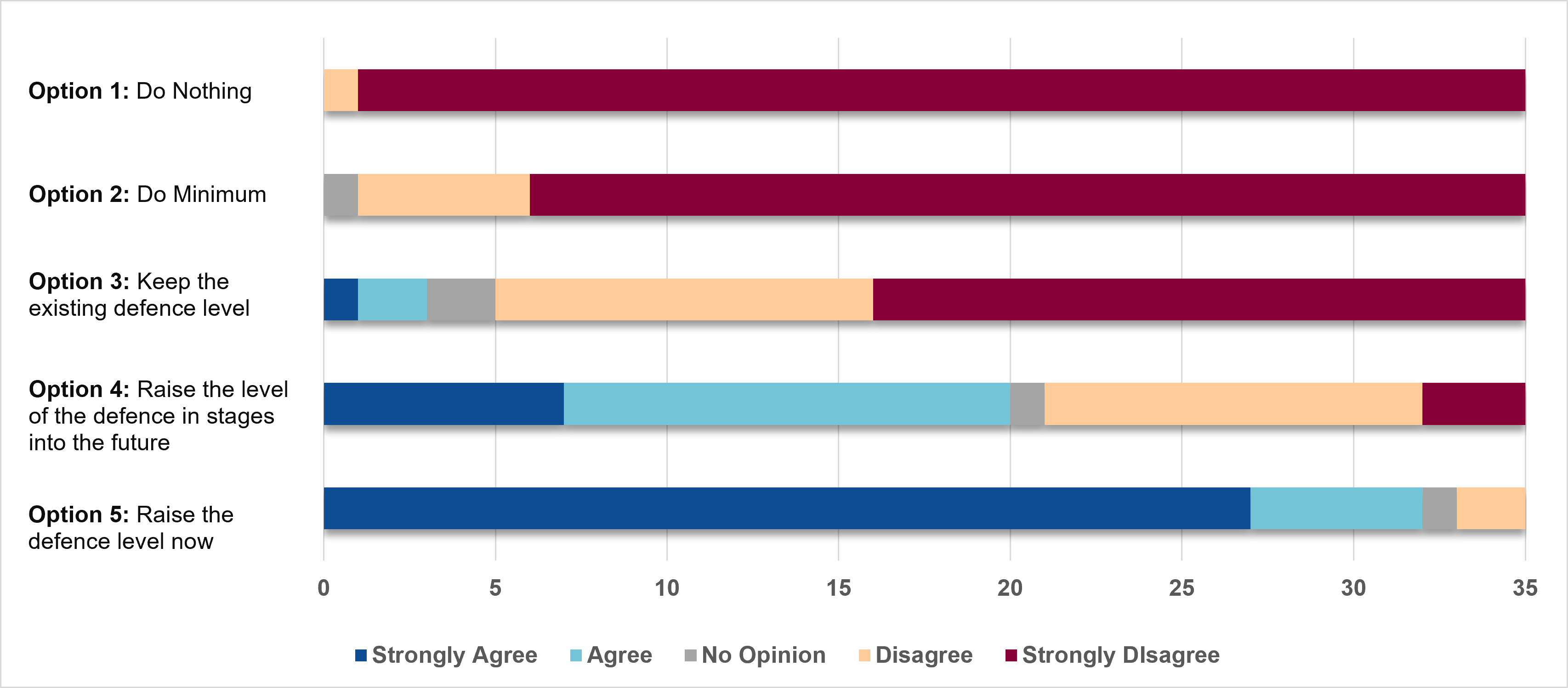
Summary of public consultation responses
We received 45 responses in total. Of the 45 responses, 35 people gave their permission for us to publish their response.
Summary of key findings from the consultation responses:
- No one favoured the do nothing or do minimal option (short list Option 1 and Option 2). Respondents told us that better protection from coastal erosion and flooding is a priority.
- Option 5 was the most favourable option to raise the defences now to address future sea level rise. A total of 32 of the 35 respondents agreed or strongly agreed with taking option 5 forward. Respondents told us that there is an interest locally in raising the height of the coastal defences to reduce the risk to Yaverland and Sandown from rising sea level both now and in the future.
The full report summarising the responses to the public consultation can be viewed here.
The flood risk assessments and financial analysis were being progressed at the same time as public consultation. This information is now available and presented below.
What did our investigation work show?
Updated flood risk assessment
Flood modelling uses predicted river flows, rainfall, and coastal levels combined with topographic data and flow equations to generate flood risk information (such as depth, velocity, flood levels, and hazards). Our team of specialists updated the coastal flood modelling for Yaverland to ensure it uses the latest information and software available.
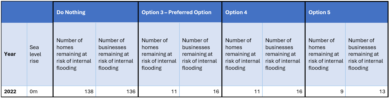
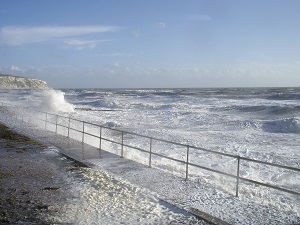
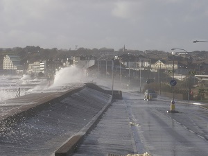
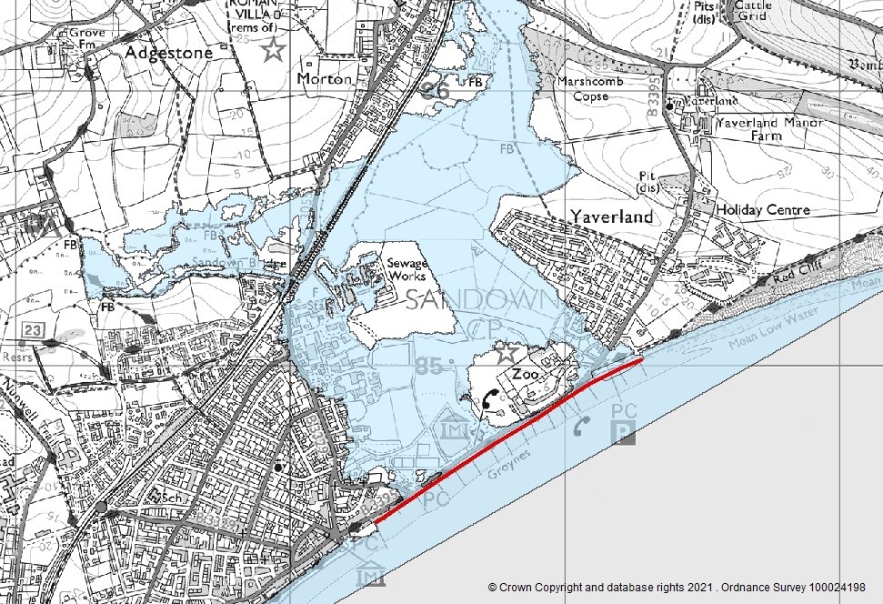
The main coastal threat to Yaverland is failure of the sea defences due to their current poor condition. Our latest modelling predicts that failure of the coastal defences would adversely impact 138 residential properties and 136 businesses. The below map shows the anticipated flood extent in the event of defences failing.
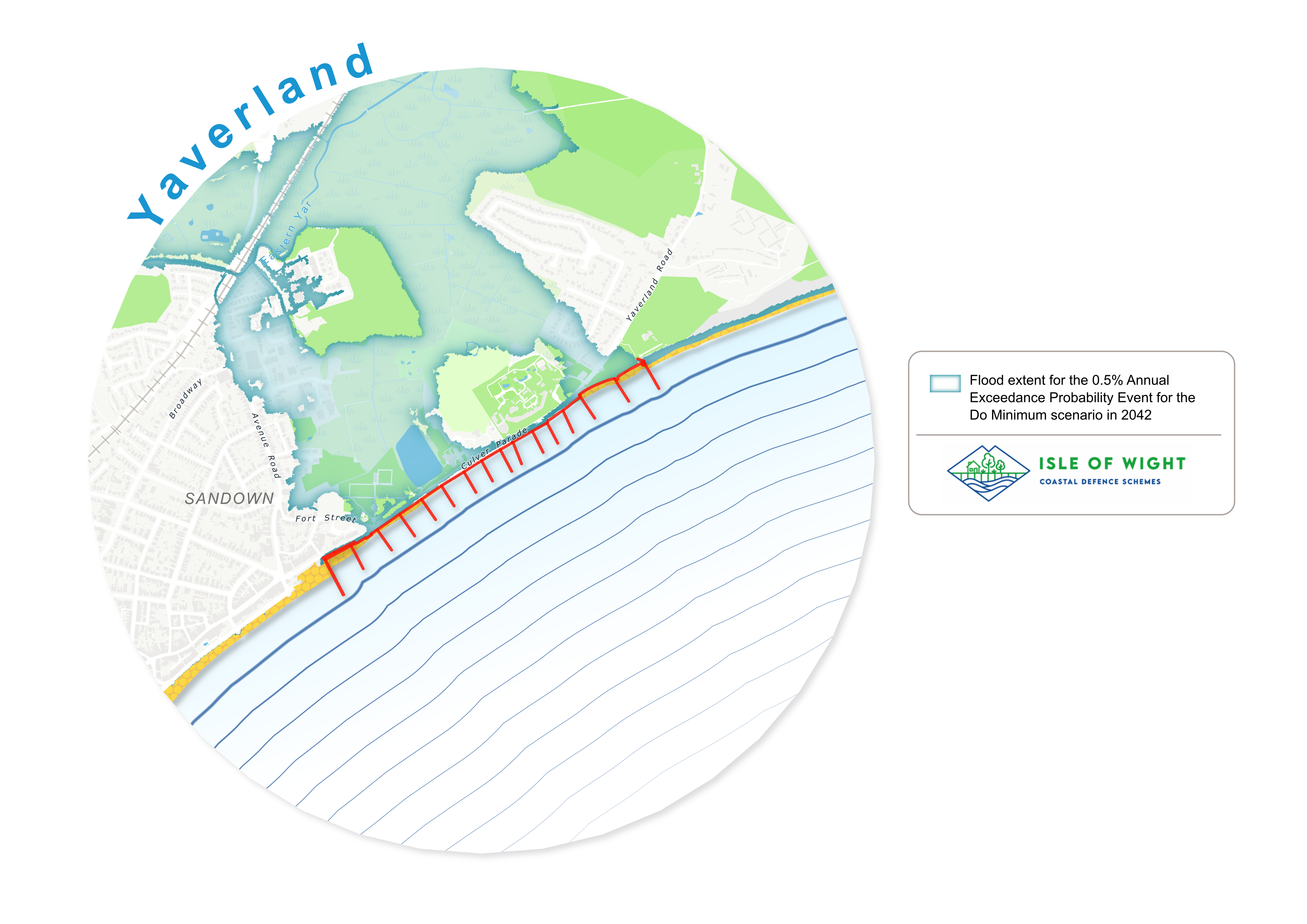
Preventing this scenario can be achieved through either Option 3, Option 4 or Option 5. Increasing the height of the coastal defences does not provide any additional erosion protection over Option 3, it only provides a greater level of protection against flooding associated with waves overtopping the seawall.
Modelling results tell us that the risk of flooding from wave overtopping is low given the existing height of the defences and raised floor levels of properties. Modelling suggests that 11 residential and 16 non-residential properties at Yaverland would remain at risk of internal flooding from overtopping after completion of Option 3.
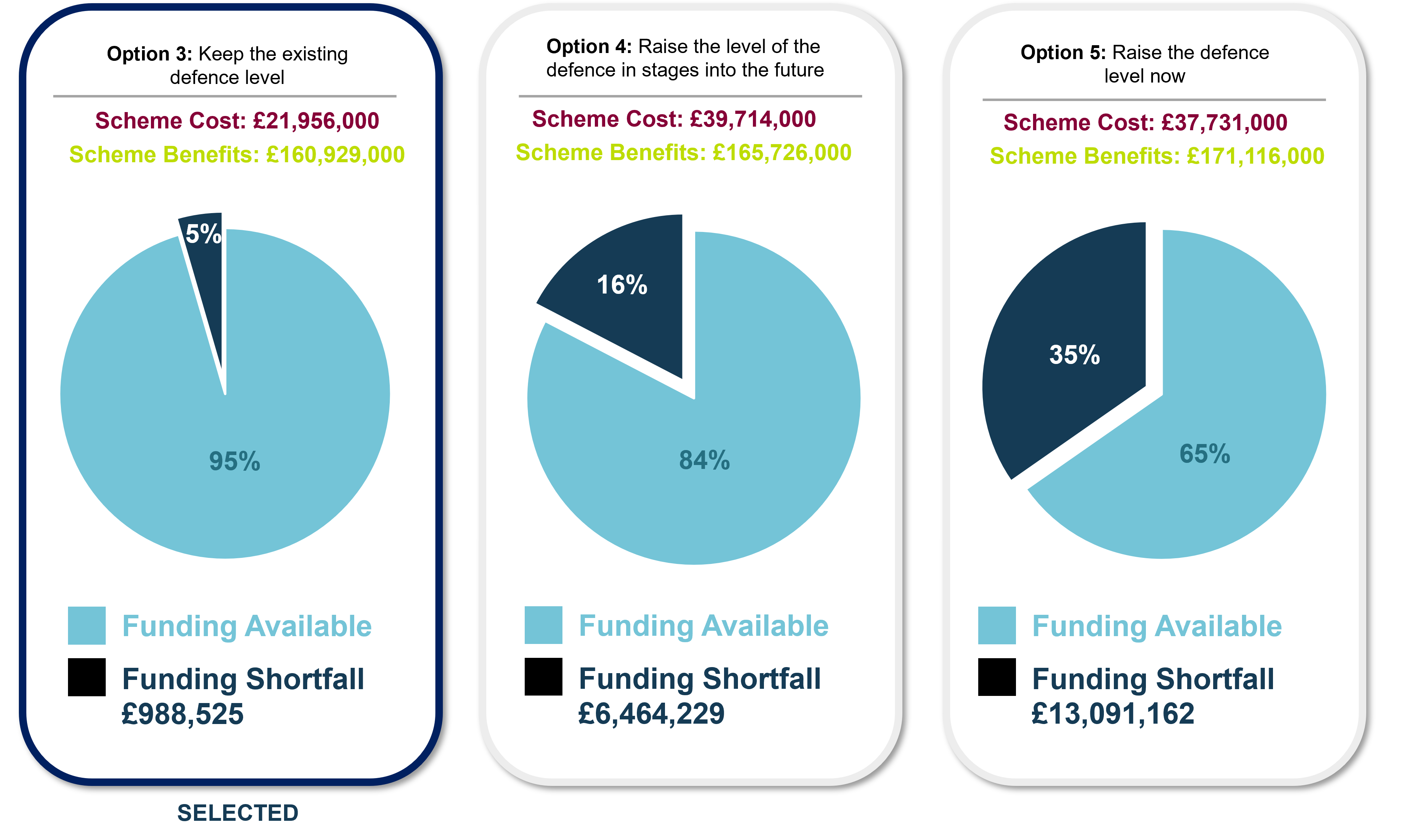
Financial analysis
Option 3 provides over £160 million worth of benefits to people, property and the environment. The additional benefits associated with Option 4 and Option 5 are not as great. The figure below shows the cost to construct Option 3 is significantly less compared with Option 4 and Option 5. Increasing the height of the sea wall almost doubles the cost of the scheme. The public consultation told us that there is interest locally in raising the height of the existing defences however the funding shortfall of £6.4million and over £13million for Option 4 and Option 5 respectively makes these unviable options for Isle of Wight Council to take forward.
Information on Flood and Coastal Erosion Risk Management schemes are funded can be found here: https://thefloodhub.co.uk/frms-funding-and-delivery/
How will the shortfall in funding for the preferred option be addressed?
As a competent authority under Habitat Regulations the Environment Agency must have regard for the protection of the designated freshwater habitat of Brading Marshes, and can therefore apply for funding set aside to protect designated habitat. This funding will only cover the costs to close a funding gap for the lowest cost option for achieving habitat protection. This is Option 3 which is the most economically viable way of protecting Brading Marshes.
The Environment Agency submitted a business case to Southern Water seeking a contribution towards the scheme as the water treatment works in Sandown will benefit from better protection from flooding from the sea. This bid has been included in Southern Water’s submission to The Water Services Regulation Authority, or Ofwat. This bid will not be determined until December 2024.
A funding strategy will be produced during the Full Business Case stage in 2025. Project costs are expected to change following more detailed costings from our contractor.
Ground investigative work
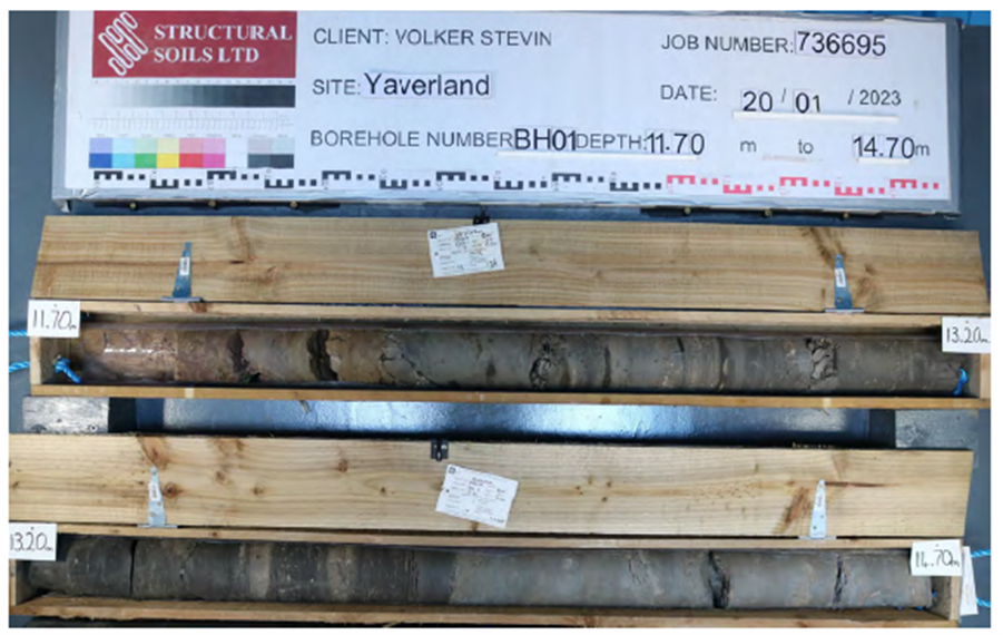
Our contractors drilled boreholes at various points on the sea wall at Culver Parade using specialist equipment to retrieve a core which was sent to the laboratory for analysis. Machine excavated trenches located at intervals along the sea wall and next to the groynes were also dug.
This work helped to increase our understanding of the existing structures and will help us plan the refurbishment work. The key findings are:
- A new area of Dinosaur Footprint was discovered during the work. The new footprints make it clear that the land on which the dinosaurs walked is likely to stretch the whole length of Yaverland beach. A palaeontologist will be on hand to keep a watchful eye over the construction work.
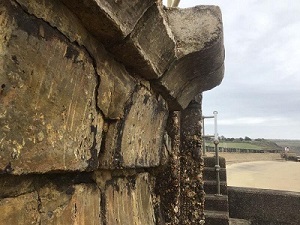
- A total of nine concrete cores were extracted at strategic locations along the concrete sea wall. The cores showed that the Wessex Formation is present as bedrock across the whole site. At the western end of the site, the Wessex Formation is reported to alternate between a Clay and a Mudstone of various degrees of weathering. The Wessex Formation is notably multicoloured, in places mottled brown and purple, reddish brown, greenish grey and bluish grey. Its strength varies with the degree of weathering from a soft Clay to a very weak Mudstone, with bands of sand and Sandstone which is highly erodible. The presence of a stepped revetment around Yaverland car park demonstrates that erosion risk through scour at the toe of the sea wall has been a concern in the past. The soft erodible bedrock will need to be a consideration as the team draw up the design.
- The sea walls are much thinner than modern engineering standards. This tells us that works to the foundations will be needed as part of the refurbishment work.
- Borehole cores extracted from the ground have been donated to the British Geological Society. Their data sets provided useful information for our projects, and we hope our contribution will help others in the future.
The below image shows two of the borehole cores extracted from the ground and stored in their wooden containers:
Coastal processes assessment
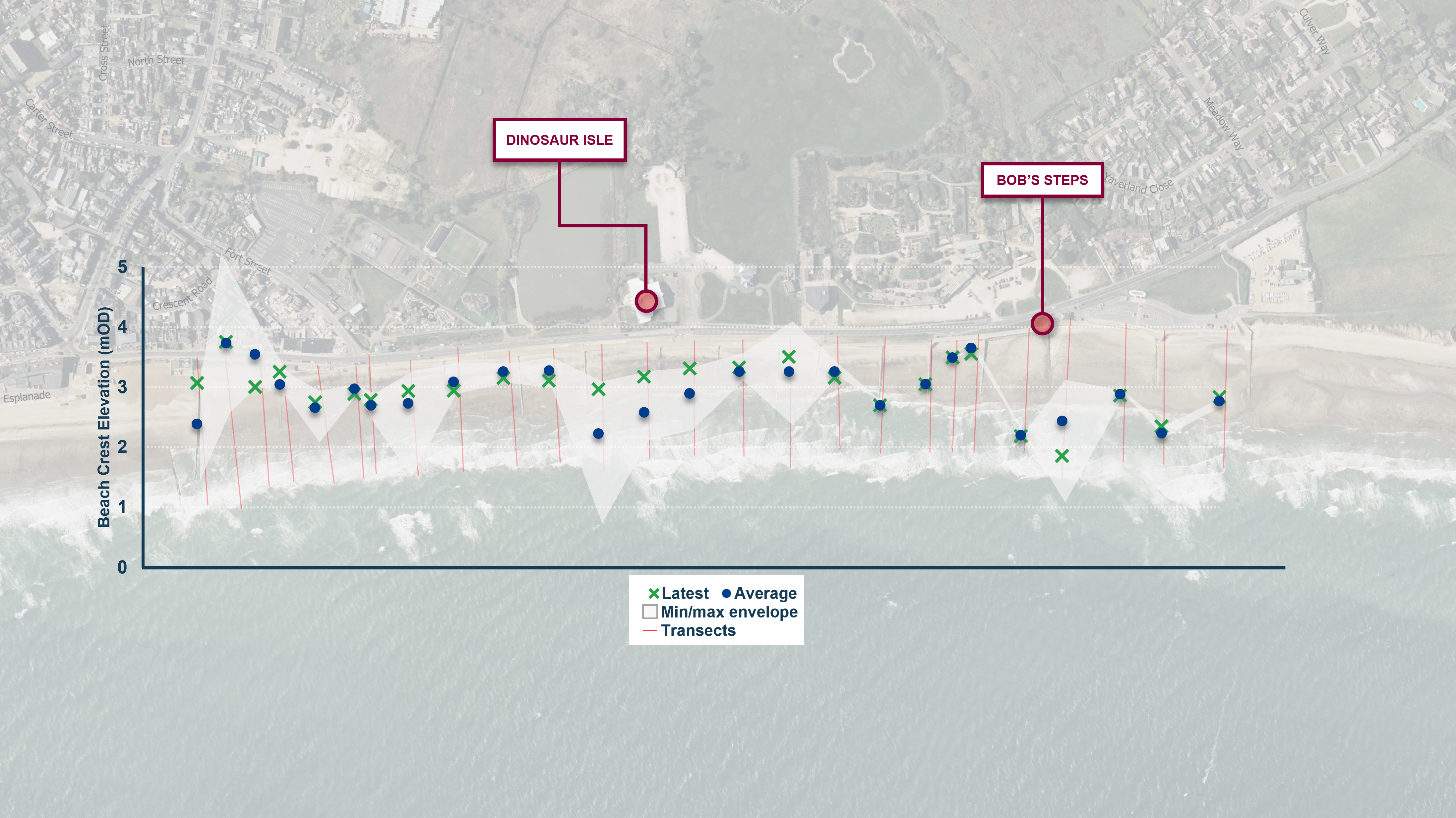
- The historic trends in beach profile from 2004 to 2020 were reviewed. The min/max envelope in the image above shows the beach level overall remains relatively stable across the survey period.
- Short term fluctuations are observed and indicate seasonal changes. Photographic records taken by Swim the Wight provide supporting evidence of this.
- The overall stable condition is attributed to the constant nourishment of sediment received from the south-north net sediment transport rate of 25,000m3/year on average.
- Satellite imagery captured evidence of North-South longshore sediment transport in 2005, 2014, and 2015. This is opposite to the predominant direction.
- Accumulation of sediment on the northern side of most of the groynes in Yaverland indicates the groynes are functioning well.
- Past storm events have caused beach levels to lower by up to 1metre in front of the sea walls.
- One of the major physical impacts of a rise in sea level includes erosion of beaches. Our coastal processes assessment shows that beach levels are expected to lower by 0.5m by 2040 and up to 3m by 2125. It is expected that the toe of the sea wall will have sufficient beach cover to protect it from erosion for the next 50 years. After this point, works to prevent scour at the toe of the sea wall may be needed.
Why was the preferred option selected?
The financial assessment compared the benefits and costs to identify the impact of each option overall. The benefits to the community of progressing Option 3 (the preferred option) outweigh the costs. The work will bring over £160 million worth of benefits to the community, the local infrastructure, and the local environment.
The figure below summarises the Short List appraisal for those options deemed to qualify for consideration as the Preferred Option (Options 3, 4 & 5).
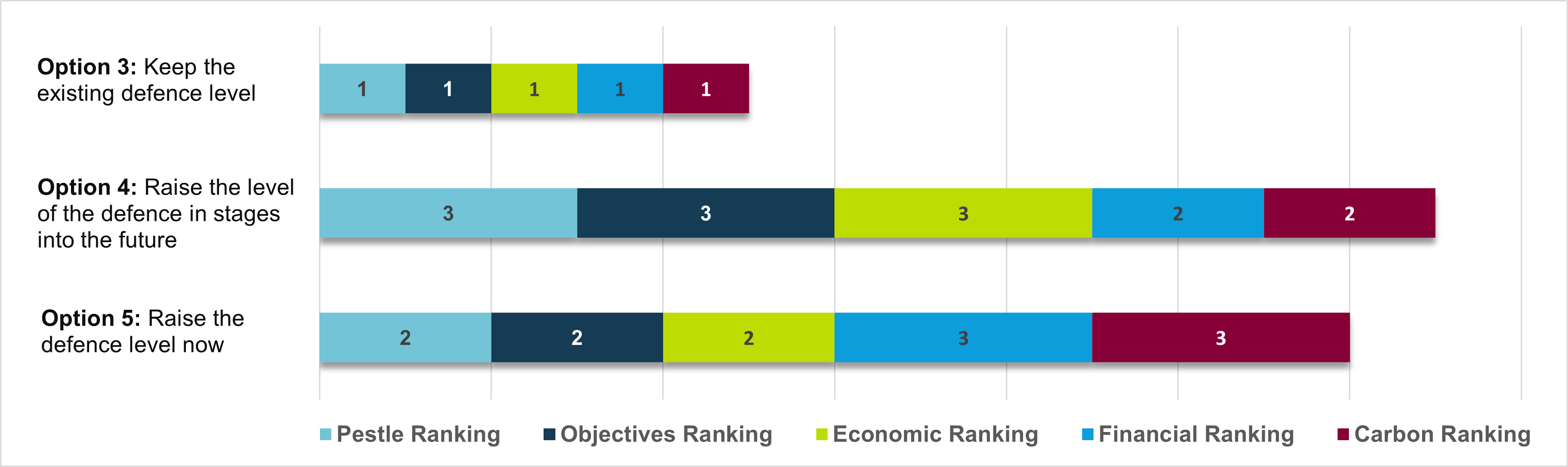
The ranking of the options is based on:
- The criteria grouped by PESTLE (Political, Economic, Social, Technical, Legal, Environmental).
- The criteria grouped by Objectives.
- Economic, Financial, and Carbon ranking
A PESTLE analysis studies the key external factors (Political, Economic, Social, Technal, Legal and Environmental) that influence an organisation or environment. It can be used in a range of different scenarios, and can guide people and professionals in strategic decision-making.
Option 3 meets all project objectives, scores highly for PESTLE criteria and scores highly for economic, financial and carbon ranking.
Option 3 also has the longest duration of benefits (50 years) when compared to the other options (20 years). Other than the usual maintenance for Isle of Wight Council and the Environment Agency, no interim works are expected in the 50 years of the scheme.
Why is the height of the sea wall not being increased?
The flood risk assessment shows that the risk of internal property flooding from waves overtopping the existing sea wall is low given the height of the existing wall and raised floor levels of properties. Only a small number of properties would remain at risk of internal flooding from waves overtopping the sea wall after the refurbishment work is complete. Our modelling estimates that 11 homes and 16 businesses would remain at risk of internal property flooding from a tidal flooding event with a 0.5% annual probability (1 in 200 chance each year). This is compared to 138 homes and 136 businesses at risk of internal flooding from the sea if we did nothing.
The financial analysis suggests that other measures such as Property Flood Resilience (PFR) measures are a more cost-effective method of reducing the risk of internal flooding to the 11 homes and 16 businesses which remain at risk after the scheme is constructed. This opportunity will be explored as part of the next phase of work on the scheme. PFR measures can include flood boards, air brick covers, non-return valves and pumps, as well as work to ensure that the fabric of the property is sound. More information about PFR can be found here: https://bluepages.org.uk/
We can never remove the risk of flooding entirely. Our flood risk assessment shows that if the height of the sea wall was to be increased, there would still be a risk of wave overtopping and associated internal property flooding. The number of properties that would remain at risk of internal flooding today if Option 4 and Option 5 were to be implemented are shown in the table below.
The results of the financial analysis have shown that the additional scheme benefits from raising the height of the sea wall do not outweigh the additional scheme costs. Increasing the height of the sea wall almost doubles the cost of the scheme. The shortfall in funding makes the option to raise the height of the sea wall an unviable option for Isle of Wight Council to take forward.
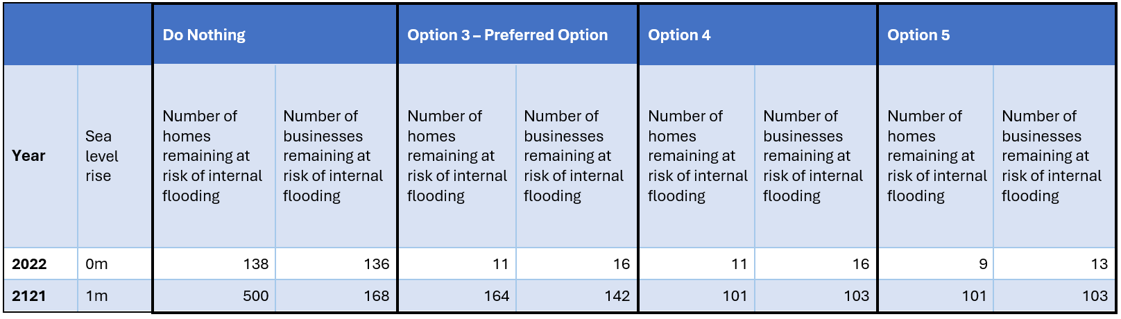
Where does this leave us in the future with sea level rise?
The risk of flooding from the sea over the next 100 years with 1 metre of sea level rise was modelled to improve our understanding of how the risk of flooding in the area may change in the future. It is estimated that without increasing the height of the sea wall, 164 homes and 142 businesses would be at risk of internal flooding from the sea by the year 2121. Raising the height of the sea wall would still leave 101 homes and 103 businesses at risk of internal property flooding from the sea by the year 2121.
As part of the refurbishment project, we will include works which strengthen the foundations of the seawall with the foresight that a decision to raise the height of the seawall may be a viable option in 50 years’ time.
Previous updates
Update 01 March 2024
In October Storm Babet forced us to change our plans and we were disappointed not to be able to go ahead with the planned exhibitions at Wildheart Animal Sanctuary and the Broadway Centre. The storms brought heavy and persistent rainfall resulting in widespread flooding impacts across the Isle of Wight. You might be interested to know that 2023 was the wettest year on record for the Island. Under such exceptional conditions, both the Environment Agency and Isle of Wight Council opened their area incident rooms to coordinate the response, staff worked 24/7 to help manage flood risk and support local communities.
The Environment Agency has specially trained Flood Support Officers across the country who provide information and advice during and after floods. Call Floodline (24-hour service) on 0345 988 1188 or type-talk (for the hard of hearing) on 0345 602 6340 if you are affected by flooding.
Once the storms had passed and impacts had subsided, we were pleased to hold public exhibitions to showcase the short list of options for refurbishing the coastal defences. We were delighted to host nearly 100 visitors at The Clifton Hotel in Shanklin. Everyone who attended welcomed the opportunity to escape the wet weather, have a warm drink, and chat to the project team and other visitors to the exhibition.
We also enjoyed Dinosaur Isle’s Blast from the Past event, where over 650 visitors passed through the doors. Our Lego table was kept busy with children creating their own sea defences. Our flood water tank was also popular with visitors, and we had the opportunity to discuss flood action plans as well as the coastal defence short list.
We want to thank everyone who took the time to come along. The report summarising the consultation responses can be viewed here:
Your browser does not support inline PDF viewing. Please download the PDF.
A copy can also be downloaded here.
Update 2nd December 2023
The Yaverland sea defence survey is now closed.
What happens next?
We have had a great response to our survey asking you to comment on the proposed shortlist for the refurbishment of Yaverland sea defences.
We will publish a summary of responses on Citizen Space within 12 weeks of this consultation closing. We will not publish any personal data. We will not respond individually to responses.
In line with the Freedom of Information Act 2000, we may be required to publish your response to this consultation, but will not include any personal information. If you have requested your response to be kept confidential, we may still be required to provide a summary of it. For more information see our Personal Information Charter.
We are running this consultation in accordance with the guidance set out in the government's consultation principles.
If you have any questions or complaints about the way this consultation has been carried out, please contact consultation.enquiries@environment-agency.gov.uk
To make sure you are fully informed please email us requesting to join our mailing list.
Update 23 November 2023
There is one week left to complete our coastal defence survey for Yaverland seafront.
Your feedback will help us to determine a preferred option for the sea defences.
Please complete our survey by 1 December 2023. The survey can be found online here. Paper copies are aslo available from Sandown Library, Shanklin Library and the Help Desk at Isle of Wight Council, County Hall, High Street, Newport, PO30 1UD.
Although the public exhibitions are over you can still view all of the material on our consultation page here.
Update 10 November 2023
The last day of our public exhibition is today, 10 November. The Coastal Defence team will be at The Clifton Hotel, 1 Queens Road, Shanklin PO37 6AN between 10:00 AM and 3:00 PM taday. You will have the opportunity to find out about the sea defences and the options for refurbishment before completing our survey.
Your feedback will help us to determine a preferred option for the sea defences.
Please complete our survey by 1 December 2023. The survey can be found online here. Paper copies are aslo available from Sandown Library, Shanklin Library and the Help Desk at Isle of Wight Council, County Hall, High Street, Newport, PO30 1UD.
If you can not make the exhibition you can find all of the material on our consultation page here.
Update 6 November 2023
The public exhibitions for our Shanklin and Yaverland Coastal Defence scheme are going ahead as planned this week.
Update 26 October 2023
October public exhibition drop in events cancelled due to flooding impacts
Due to the impact of heavy rainfall and flooding across the Isle of Wight we have made the difficult decision to cancel the public exhibition drop in events at Wildheart Animal Sanctuary and the Broadway Centre for the Yaverland and Shanklin Coastal Defence Schemes which were due to take place this week.
Our staff are currently prioritising our incident response work. The health, safety and wellbeing of our staff and members of the public is a priority. We expect to go ahead with the rest of our schedule of events as planned in November. We are checking venue availability and will update this page with a revised date for the Yaverland and Sandown exhibitions.
The consultation is still live. You can view our exhibition material online in the meantime. Head over to our consultation page here.
Your browser does not support inline PDF viewing. Please download the PDF.
A copy of the poster can be downloaded here.
Our latest newsletter can be viewed here:
Your browser does not support inline PDF viewing. Please download the PDF.
Update 06 January 2023
Newsletter
Our latest newsletter is available here.
A plain text version is available here.
A word version is available here.
Ground investigation work
Ground investigation work starts on Monday 16 January 2023. Specialist equipment will be used to drill boreholes through the sea wall and retrieve concrete cores which are sent to the laboratory for analysis. Machine excavated trenches located at intervals along the sea wall and next to the groynes will also be required. The results from the investigations will give the project team information about the composition of the ground and existing foundations where the coastal defence refurbishment is being proposed. Further details can be found here.
Yaverland Coastal Defence Scheme questionnaire
We sought views on how the Yaverland coastal frontage and nearby leisure/tourism offering is used, what is most valued about it, and the perceptions amongst stakeholders of flood and coastal erosion risks both now and in the future. This will help to inform how we engage with stakeholders going forward, and capture any concerns, ideas and opportunities in the shortlist of options that we present to the public in Summer 2023.
We received 44 responses in total. 39 responses were made via the Yaverland Coastal Defence Scheme Information Page; 5 were made via paper copies held at Sandown Library.
Individuals who wish to follow up their responses, or points made within this document, in more detail are welcome to contact us at IOW_FDschemes@environment-agency.gov.uk.
A copy of the response summary can be found here.
Our latest newsletter can be viewed here:
Your browser does not support inline PDF viewing. Please download the PDF.
A copy of our latest newsletter can be downloaded here.
If you require this in another format please don't hesitate to contact us at IOW_FDschemes@environment-agency.gov.uk
The Environment Agency have created this page to provide easy access to information on the Yaverland project, one of four priority coastal defence projects on the Isle of Wight. The Environment Agency will be updating this site as the project progresses, so please keep checking for what’s new.
Please get in touch if you need any of the documents on this site sent to you in a different format. We would be happy to help.
For information about other coastal defence projects on the Isle of Wight see here.
Background

The Sandown Bay coastal frontage is a popular tourist and amenity area with its long sandy beach, esplanade and attractions. This project aims to address the flood risk and coastal erosion challenges facing this stretch of coastline.
This work aims to enhance the seafront for future generations and assist regeneration, whilst reducing flood risk to the community and preserving the area’s tourism and heritage value. Additionally, the project will explore longer term flood and erosion risk management options and make recommendations for a sustainable coastline for future generations.
More Information
More Information
More Information
More Information
More Information
Frequently asked questions can be viewed here.
Get in touch
Thank you for visiting our project page.
Please contact us:
By email: IOW_FDschemes@environment-agency.gov.uk
By post: Environment Agency, Romsey Office, Canal Walk, Romsey, SO51 8DU
By phone: 03708 506 506
If:
- you are not able to access any of the information on this page.
- you have any comments or feedback on our information page.
- you have any questions or concerns about the project.
If you would like to be added to our mailing list, please email us.
For more information on how we will use and share your data, please see our Privacy Notice and our Personal Information Charter
Events
-
Family friendly community information event
From 18 Feb 2025 at 14:00 to 18 Feb 2025 at 18:30Where?
Browns Golf & PLUTO's Café
Culver Parade
Sandown
PO36 8QAWhat?
A family friendly community information event.Free hot and cold drinks available.
Interactive activities for children.
Fully accessible venue.
Baby change facilities available.
Well behaved dogs welcome!
-
Online presentation from the project team
From 10 Mar 2025 at 18:30 to 10 Mar 2025 at 20:00Online presentation from the team behind the Yaverland Coastal Defence Scheme.
To register for this event please email: IOW_FDschemes@environment-agency.gov.uk
Audiences
- Anyone from any background
Interests
- Coastal management
- Flood management
- Specific projects, issues, or activity pages
Share
Share on Twitter Share on Facebook