The River Roding Project information page
Overview
Updated 12 March 2025
This page provides a summary of the latest progress and an overview of our project which aims to reduce flooding to homes, businesses and infrastructure in the Woodford and Ilford areas. It also sets out who you can contact for further information, and how to request to be added to our mailing list.
There is a set of Frequently Asked Questions at the bottom of the page, which will be updated regularly throughout the construction phase.
This will be the last time this page is updated as we will be moving across to a new platform ahead of the next update later in the spring. We will post a link to our new page here and send an email to our mailing list when the new page goes live.
Latest project progress
Since our last update in October 2024, key developments include:
- Completion of the first phase of the river diversion (the channel is excavated, but connection to the river through the control structure will happen later in the programme)
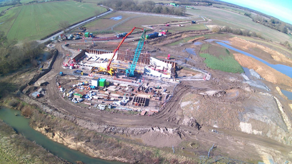
- Significant progress on the control structure, with the concrete base and some of the walls of the structure now in place
- Engagement with the London Borough of Redbridge at their scrutiny meeting in November, to raise the profile of the project and to discuss how they can further financially support the project
Figure 1 below shows the location of these works and there is further detail on the key project activities below.
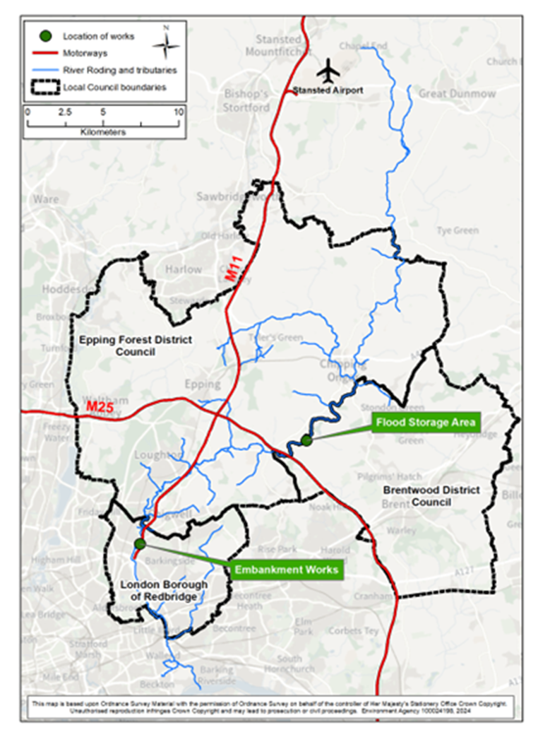
Above: Figure 1 - map showing the location of the River Roding project works
Above: Figure 2 - Aerial shot of the site, showing progress on the control structure
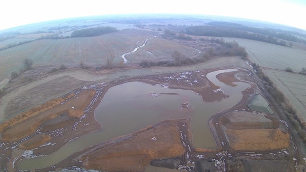
Above: Figure 3 - Aerial shot showing the first phase of the River Diversion which the River Roding will be diverted through later in the construction programme
Control structure
The control structure is an important element of the project which will control the amount of flow the river passes downstream to provide flood risk benefit to communities. Once complete, the River Roding will be diverted through this structure.
The majority of the work on site over the last few months has been focused on this and figure 4 below shows the significant progress that has been made.
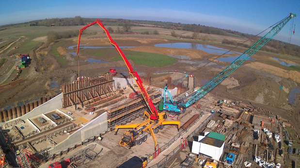
Above: Figure 4 - Control structure progress as of 3 March 2025
Below, figure 5 shows the site from above and the location of the individual activities being undertaken by BAM Nuttall. Additional detail of each activity is in the table below the image.
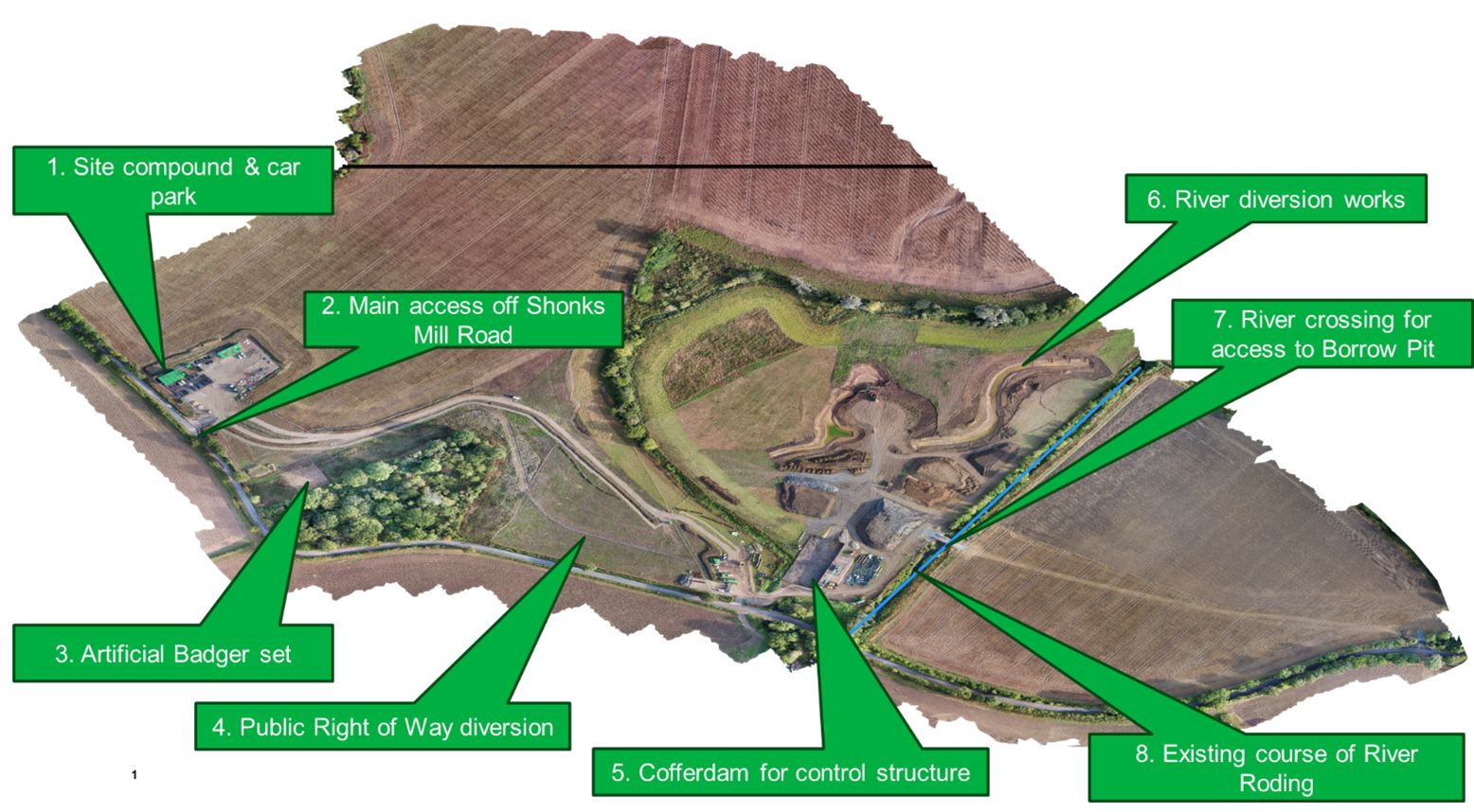
Above: Figure 5 - aerial view of the site
|
Image reference |
Description of work being delivered |
|
This was one of the early activities which was completed to provide welfare facilities, office space and car parking for the site. |
|
This access point was established early in the programme of works, to enable vehicles to safely enter the site. Road closures were in place whilst it was implemented, but now it is the main access point, and the road is open as usual. Signage has been installed so that passers-by and those entering the site understand who is working there and what the project is about. |
|
An artificial badger set has been built adjacent to the woodland to provide an alternative home for the local badger population away from the main work area. |
|
The Public Right of Way (footpath) which crosses the site needed to be diverted as the original route will be inaccessible once the embankment is constructed. This new route is now in place on the ground and remains accessible to anyone who wants to use it (with a gate which will be opened when required). |
|
The cofferdam is now a dry working area, which allows construction of the control structure. The control structure is an important element of the project which controls the amount of flow which the river passes downstream to provide flood risk benefit to communities. |
|
The River Roding is being diverted through a new wetland as part of the project, and the work to create the new channel is now complete. This will not be connected at the upstream and downstream ends until the control structure is complete. |
|
The project is utilising a field to the eastern side of the site to excavate material (clay), which will be used to construct the earth embankment. For this to be accessible to the contractors on site, a temporary bridge has been put in place, allowing vehicle access to the other side of the river. It will be removed once the project is complete. |
|
The blue line on the image shows the existing, overly straightened, course of the River Roding. As explained above, part of the project includes diverting this river through a new wetland area, before it passes through the control structure. |
What's next?
The diagram below shows the high-level activities which will take place within the next 6 months of the flood storage area construction programme:
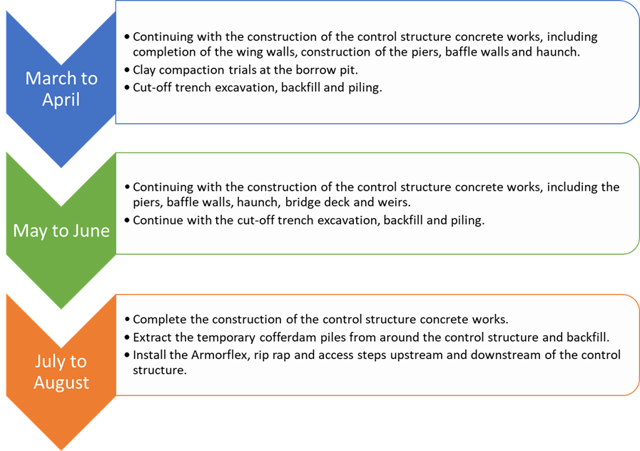
We will update this diagram regularly as the project progresses. We expect to complete the construction in early 2027.
Why are we doing these works?
There has been an increased frequency of flood events over the past 20 years. The most serious flood in recent decades occurred in October/November 2000. Over 400 homes in Woodford were flooded, there was widespread disruption to local infrastructure and major roads (including Charlie Browns roundabout) were closed for over a week. Climate change data shows that the frequency and intensity of such events will increase over the coming years, so it is important we reduce the impact of flooding on the local area.
As well as the economic damage that occurs after a flood event, flooding also has an impact on peoples' wellbeing. Flooding often causes financial stress, disruptions to daily life and can impact peoples' mental health (see figure 6 below).

Above: Figure 6 - Some of the impacts flooding can have on people's wellbeing
The photos below show flood events which have affected the communities in Woodford and Ilford.
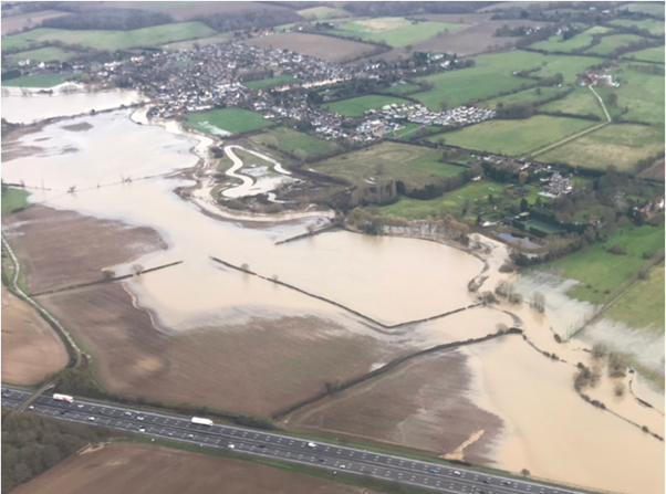
Above: Figure 7 - Aerial photograph of the Roding flooding in December 2019, taken by a local resident
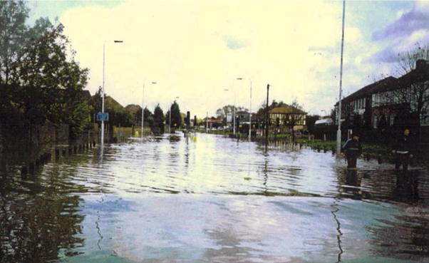
Above: Figure 8 - Photo taken during the floods in 2000.
Project background
The River Roding Project will reduce flooding to residential properties, commercial properties and infrastructure in the Woodford and Ilford areas.
The project includes building a flood storage area on the River Roding, upstream of the M25, at Shonks Mill Bridge. The flood storage area will allow the river to flow naturally most of the time, however in times of high flows, water will build up and be stored behind the earth embankment creating a temporary reservoir, reducing the risk of flooding downstream. This will then drain naturally back into the river as flows reduce.
The project also includes refurbishing a flood embankment downstream in Woodford to withstand the estimated impacts of climate change.
The before and after diagrams in figure 9 below show how a flood storage area works. In times of high flows, flood water is held behind the earth embankment while a controlled flow will be able to pass through the structure, reducing the flow, and extent of flooding downstream.
Figure 10 below shows an artists impression of how the embankment will look on the River Roding at Shonks Mill once it is complete.

Above: Figure 9 - Diagram showing how flood risk is reduced to downstream communities by a flood embankment and control structure
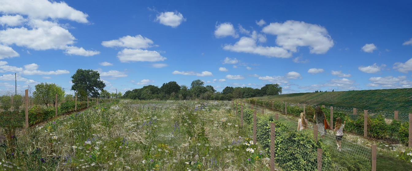
Above: Figure 10 - Artists impression of the completed flood storage area embankment above Shonks Mill Road
If you would like to ask the project team any questions, then please contact us using the email address on the right-hand side of this page. If you would like to be added to our mailing list so that you are kept updated about the project, and notified when this website is updated then please send us an email and we will add you to our list.
Please note our proposals will reduce the risk of flooding and climate change impact but will not eliminate the risk altogether.
Are you prepared for flooding?
- Sign up to flood warnings and give yourself time to protect yourselves and your valuables. Visit www.gov.uk/sign-up-for-flood-warnings or call Floodline on 0345 988 1188 to check your areas is covered and sign up to receive real-time alerts.
- Know what to do if it floods with a personal flood plan. Download a template: www.gov.uk/government/publications/personal-flood-plan
-
Help your community build flood resilience by creating a community flood plan. Download a template: www.gov.uk/government/publications/community-flood-plan-template
Audiences
- Recreational and commercial river users
- Fishing clubs and representative associations
- Members of the public with an interest in the river, the species and conservation
- Businesses
- Charities
- Statutory organisations
- NGOs
- Members of the public
- Elected representatives, including MPs
- Local councils
- Local authorities
- District and parish councils
- Environmental bodies
- Land owners
- Water companies
- Members of the public
- Recreational and commercial river users
- Community groups
- Flood action groups
- Members of the public
- Community groups
- Lead Local Flood Authorities
- Local Risk Management Authorities
- Members of the public
- Town and parish councils
Interests
- Flood management
- Water quality
- Habitats and wildlife
- Specific projects, issues, or activity pages


Share
Share on Twitter Share on Facebook