Thorney Island Habitat Creation Project Information Page
Overview
Welcome to the Thorney Island Habitat Creation Project
The Environment Agency have created this page to provide easy access to information on the Thorney Island Habitat Creation Project. This page will be updated as the project progresses, so please check back for project updates.
If you would like to be added to our mailing list and receive project updates, please email Thorney.Island@environment-agency.gov.uk
Project Vision
The creation of compensatory intertidal habitat by 2030 to contribute to the regional Habitat Creation and Restoration Programme (HCRP).
Background
Intertidal habitat is rapidly declining in Chichester Harbour and the wider Solent. In 2019 the Environment Agency (EA) partnered with the Ministry of Defence (MOD), Chichester Harbour Conservancy (CHC), JBA Consulting and Volker Stevin to explore developing an intertidal habitat creation project on the south-western edge of Thorney Island.
The proposed project involves constructing a new flood defence which will be set back to protect the barracks. Existing defences will then be breached, allowing seawater to come in and cover the low-lying land as the tide goes in and out. This will enable new intertidal habitat (saltmarsh and mudflats) to develop on the land seaward of the new defence over time.
The project team are currently in the process of investigating the alignment of the set-back defence and what the defence will look like. There are several factors that will inform the design, including:
- ground conditions
- natural topography
- proximity to MOD infrastructure
- landowner requirements
- protected species and important terrestrial habitats
- known and unknown heritage assets
- financial assessments
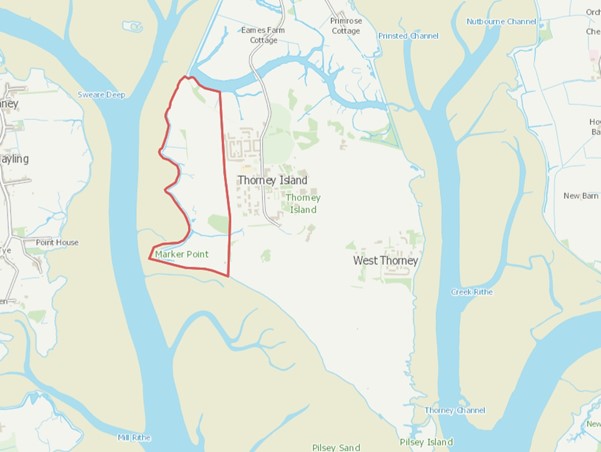
Figure 1: Location of the proposed managed realignment site on Thorney Island
Newsletters
June/July 2024
April 2024
Saltmarsh within Chichester Harbour has been in rapid decline in recent years, due to climate change. Sea level rise and existing sea defences prevent the intertidal zone moving inland, and saltmarsh is destroyed and not replaced. This project will provide compensatory habitat and secure the future of this important habitat within Chichester Harbour.
Currently the existing footpath along this part of Thorney Island is not always accessible, due to high tides and difficult walking conditions.
Our project will provide a variety of benefits including;
- supporting international designated habitats, Special Areas of Conservation (SAC) and Special Protection Areas (SPAs)
- fish nurseries
- increased habitat space for birds and other species
- attenuation of wave energy in the wider Chichester Harbour
- filtering pollutants to improve water quality
- carbon sequestration
- safer and more resilient footpath
- new and improved flood defences
The scheme will bring about significant benefits to the environment and wildlife, securing vital saltmarsh habitat within Chichester Harbour for future generations to enjoy.
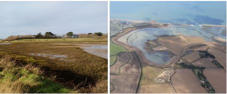
A number of managed realignment schemes have been successfully achieved within the Solent. Figure 2. below shows the small scheme at Cobnor, and the much larger Medmerry scheme.

Figure 2: (Left) Intertidal habitat creation scheme at Cobnor. (Right) Managed Realignment scheme at Medmerry
What if we do nothing?
Intertidal habitat is rapidly declining in Chichester Harbour and the wider Solent due to past and on-going development and sea level rise. As sea levels rise due to climate change, the natural intertidal habitats (mudflat and saltmarsh) are unable to naturally move landward as they become constrained against the defences. This process is resulting in a wide scale loss of intertidal habitat in the Solent. In recent years there has been a dramatic decline in saltmarsh habitat in Chichester Harbour. Natural England is currently assessing the extent of this. This process is called coastal squeeze (Figure 3).

Figure 3: Diagram showing how the presence of coastal defences can lead to the loss of intertidal habitats resulting in coastal squeeze.
Challenges
Ground investigations and surveys were completed in November 2020 to help inform the design of the new defences and to understand:
- type of ground and geology
- water levels
- presence and extent of contaminants
- likelihood of finding archaeology
- likelihood of finding unexploded ordnance.
The results of these investigations were reviewed in winter 2020, and confirmed low but significant concentrations of the insecticide Dichlorodiphenyltrichloroethane (DDT) in a number of sites across the project area.
Whilst the DDT levels found are safe and acceptable for current farming uses, the lack of UK regulation regarding safe levels of DDT release into the marine environment has slowed the pace of the project.
To address this issue, the project team worked closely with several partners including globally recognised marine consultants and modellers, EA specialists, the MOD, Chichester Harbour Conservancy and Natural England to develop a comprehensive DDT risk assessment. This was to ensure that the project team considered how to mitigate any risks identified.
Following this extensive three-year investigation and modelling phase, several mitigation options have now been identified, which include the removal of soil, and containment of contamination.
Current updates
Please refer to the newsletters to find out more about current project dates, including future public information events.
Past documents
Get in touch
Thank you for visiting our project page.
Please contact:
Thorney.Island@environment-agency.gov.uk
if:
- you are not able to access any of the information on this page
- your have any comments or feedback on our information page
- your have any questions about the project
If you would like to be added to our distribution list to receive updates on the project, please complete and return the form below.
For more information on how we will use and share your data, please see our Privacy Notice below and our Personal Information Charter
Audiences
- Businesses
- Charities
- Statutory organisations
- NGOs
- Members of the public
- Elected representatives, including MPs
- Community groups
- Flood action groups
- Members of the public
- Community groups
- Non-governmental organisations with an interest in environmental issues
- Environment Agency colleagues
- Lead Local Flood Authorities
- Local Risk Management Authorities
- Flood Resilience Forums
- Members of the public
- Town and parish councils
- Regional Flood and Coastal Committees
- Internal Drainage Boards
Interests
- Business and industry
- Flood management
- Coastal management
- Fishing and boating
- Habitats and wildlife
- Specific projects, issues, or activity pages


Share
Share on Twitter Share on Facebook