Gadebridge Park river restoration information page
Overview
We're working with Dacorum Borough Council and Affinity Water to restore the River Gade at Gadebridge Park, a globally rare and valuable chalk stream. The project will provide multiple benefits, including improved habitats for wildlife, better resilience to low flows and the impacts of climate change, reduced pooling of flood water in the park, and allowing local residents and visitors to get closer to the river and enjoy nature.
Our project will improve the river in the lower section of Gadebridge Park, between the Grade II listed White Bridge and Queensway.
Together with Affinity Water, we are funding the river restoration project and Dacorum Borough Council will be contributing to its recreational and amenity aspects. Construction began in Autumn 2024 and is expected to complete in June 2025.
This information page will be updated to share our progress. Detailed information about the River Gade and our proposals can be found further below.
--------------------------------------------------------------------------------------------
July 2025 – project update
Aside from a few remaining last tasks, our project is complete!
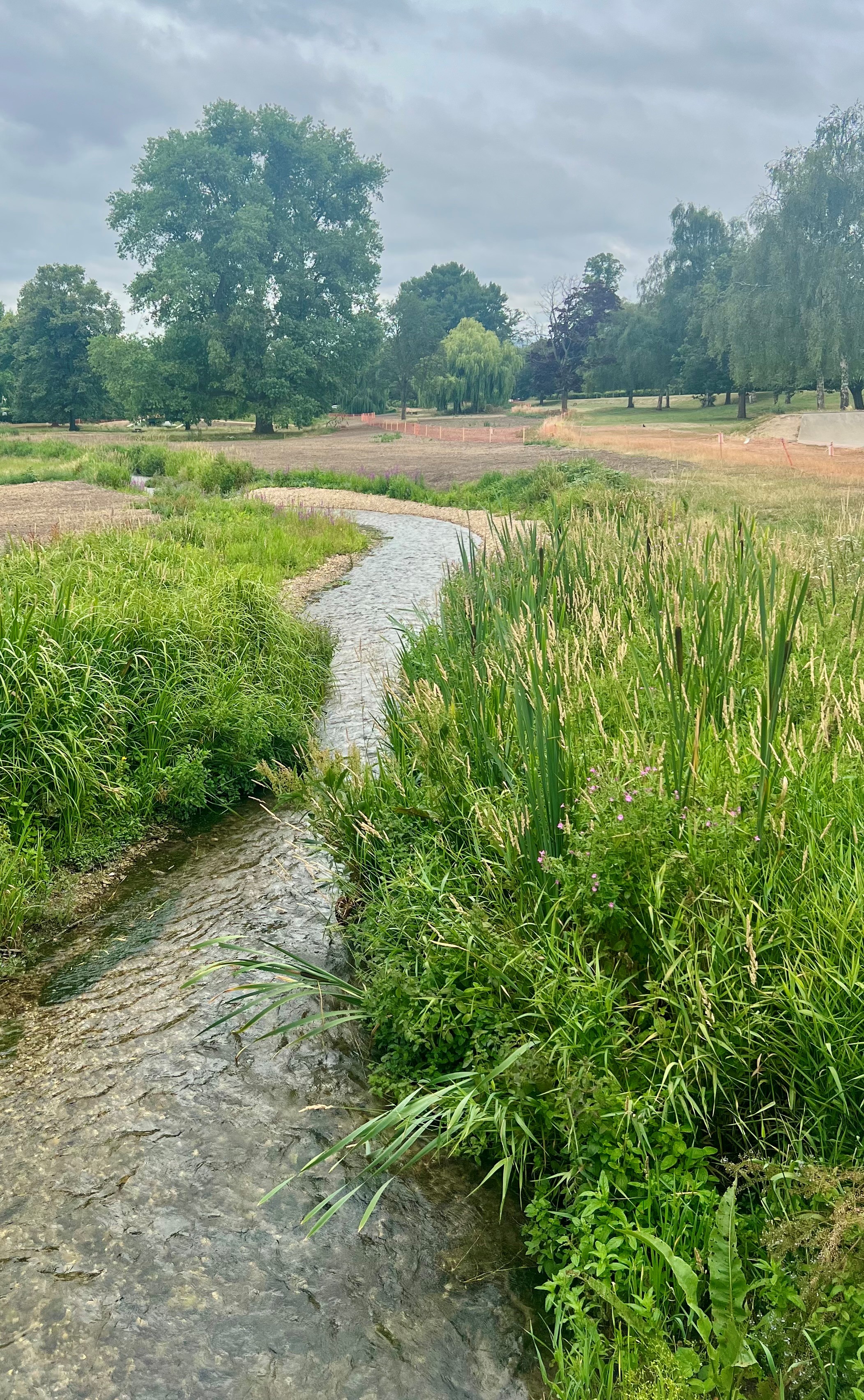
The newly restored river and riverside planting
Having been in its unnatural perched position to the side of the park for hundreds of years - artificially straight and clogged with vegetation and silt - this rare chalk stream now winds its way along its natural route through the centre of the park.
Our construction phase has come to an end and our contractor, BAM Nuttall, (and all their machinery and vehicles) has left the site. It’s not quite the end of our work here though…
Bridge works
While the new access point and central footbridge remain closed, you may notice some activity on the bridge at the end of this month/beginning of August. Our contractors will be installing railings to ensure everyone’s safety once open. The work is taking place within the fenced off area.
Grass seeding and fencing
The areas that are still fenced off are essential to give the thousands of young plants and freshly seeded areas the time and space they need to properly establish. We can’t give a timescale to when the fencing will be removed right now. We’re keeping a close eye on these areas, especially given the hot, dry weather we’ve been experiencing.
Initially, we didn’t water the seeded areas, as it’s recommended to leave the seed to germinate naturally once the conditions are right. Until this time, the seed will remain dormant. Following a period of rain, quickly followed by very high temperatures, we investigated the possibility of using sprinklers, however the areas were deemed too large to irrigate successfully. Any water would likely just evaporate on hot days. We also felt it was inappropriate to use such large volumes of water while advising others to conserve water at this time.
Instead, and in agreement with Dacorum Borough Council, we will monitor the establishment of the grass and decide in autumn whether reseeding is necessary - at which point, conditions should be more favourable for growth. For now, we’ll keep the fences in place to protect these areas.
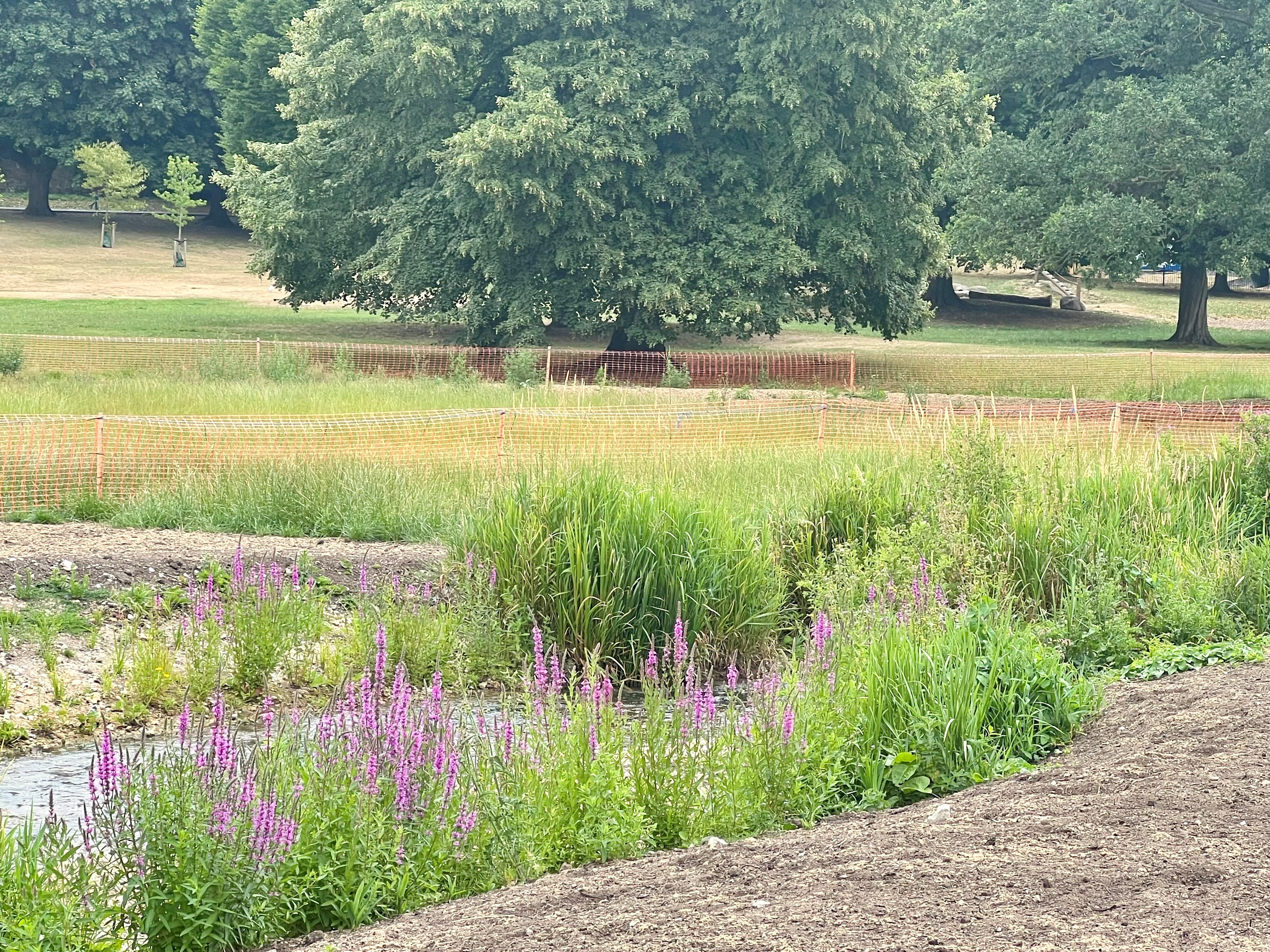
Riverbank planting - the butterflies are particularly enjoying the Purple Loosestrife
New footpath
Our earlier plans included the installation of an accessible footpath. This is still being delivered - just slightly later than originally planned. While it was part of our early designs, we needed to find some efficiencies to ensure we could prioritise and complete the key environmental elements of the project. As a result, the footpath is now being delivered as a separate piece of work, funded and led by Dacorum Borough Council.
We’re really pleased to be working with the council to make sure this part of the park is accessible to everyone. They’ve secured funding and are aiming to install the footpath as soon as possible.
Surveys and monitoring
We’ve been carrying out several surveys throughout July to establish a baseline for our records. This includes vegetation, river fly and fish surveys.
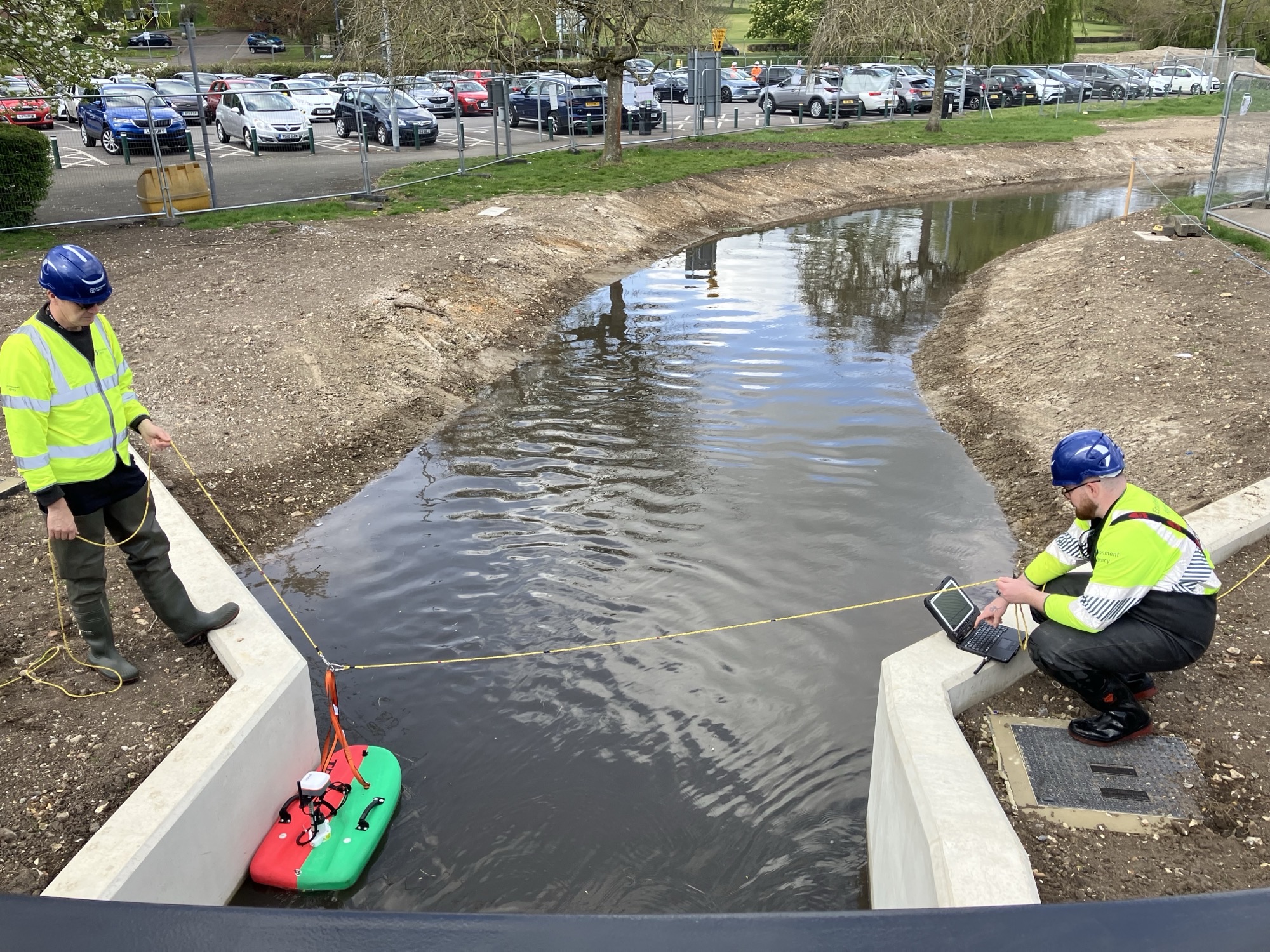
Our field teams will be visiting weekly over the summer to clean the new gauging structure which measures river flows and supports us in delivering our flood warning service. They’ll also carry out monthly spot flow gauging to ensure the new equipment is accurately recording river flow data. Spot flow gauging involves measuring the discharge (the volume of water) at a specific point in time (see photo below).
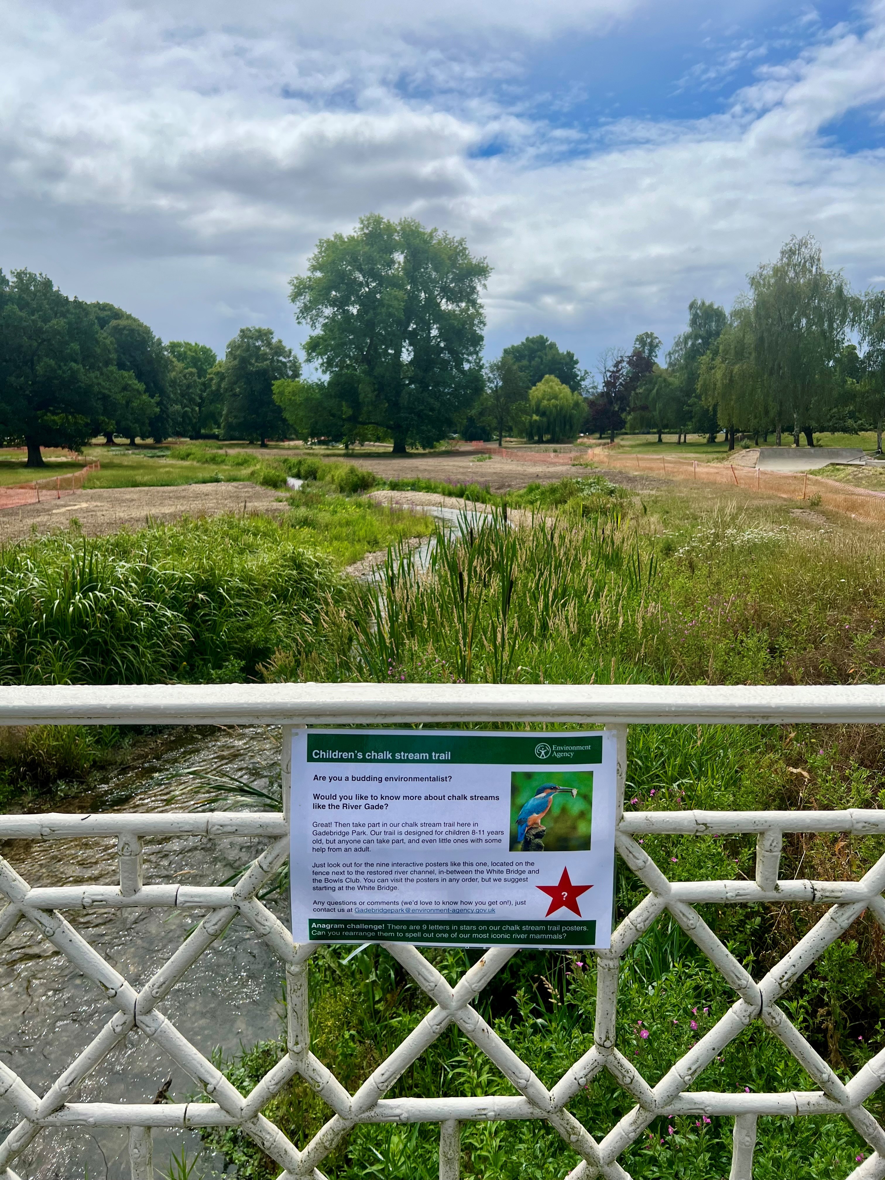
Children’s chalk stream trail
Do you know a budding environmentalist? Then head down to Gadebridge Park over the summer holidays and take part in our children’s chalk stream trail. It’s designed for 8–11 year olds, but anyone can take part and even littler ones with the help of an adult. Just start at the White Bridge and find the nine chalk stream fact posters with a bright red star (see example below), located on the fencing next to the newly restored river between the White Bridge and the Bowls Club. The posters are full of interesting facts, questions to ponder and QR codes linking to informative videos.
And finally...thank you for everyone's patience and support during construction – it’s been so heartening to see how valued the environment and its wildlife are here in Hemel Hempstead.
Any questions?
A frequently asked questions (FAQs) document, ‘Appendix 1 – Gadebridge Park river restoration FAQs 2025’, is available under ‘Related’ right at the bottom of this page. It includes answers to many questions about everything from chalk streams to our archaeological finds!
If you have any questions you can also email us at gadebridgepark@environment-agency.gov.uk.
Join our mailing list
Although our tasks at Gadebridge Park are coming to an end, we still plan to send out future updates by email to our mailing list over the next few months. These won’t be as frequent, but we'll update everyone about any remaining tasks, such as the necessity for re-seeding for example. We’ll also share the results from our surveys. And if we spot any exciting species enjoying the newly restored channel, we'll be sure to let you know!
If you'd like to receive these updates, please send your email address to gadebridgepark@environment-agency.gov.uk. We will not use your contact details for any other purposes.
--------------------------------------------------------------------------------------------
Why does the River Gade need improving?
The River Gade is a chalk stream; a globally rare and valuable habitat. 85% of the world’s chalk streams are in England and 30% (68) of these are in the south east. Unlike most rivers, chalk streams are fed from chalk aquifers - underground porous rock formations which store water. Chalk streams are directly connected to these aquifers, making their water mineral rich, clean and at a consistent temperature. This unique habitat provides the ideal conditions for a diverse range of plants and animals. Chalk streams are home to some of our most threatened species, such as the Water Vole and Brown Trout.
At the moment, only 17% of chalk streams are in their natural state. Like many chalk streams, the River Gade faces pressure from low flows and historic modifications to its channel that limit the river’s habitats and the wildlife it can support. The stretch of the River Gade that flows through Gadebridge Park is currently classified as having a 'Poor Ecological Status' under the Water Framework Directive (WFD).
Historic modifications
In Gadebridge Park the River Gade flows down an artificial channel created to supply water to the now demolished Bury Mill. The artificial channel is ‘perched’, meaning that it sits at a higher level than the valley bottom - the natural course of the river through the park. This means that the river is disconnected from its floodplain. When flooding occurs in the valley bottom, the water remains in the park for long periods of time because it is unable to flow back into the channel.
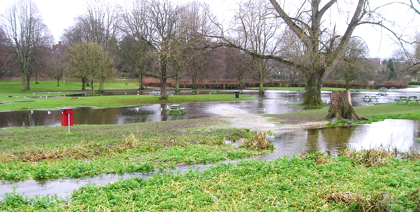
Image 1: Prolonged flooding in Gadebridge Park. The water is not able to flow back into the ‘perched’ channel.
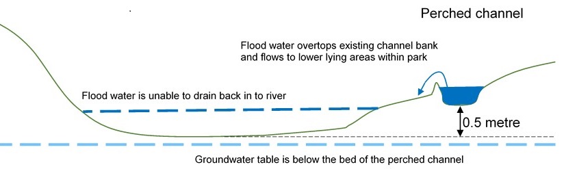 Image 2: A diagram showing a perched channel.
The artificial channel is much wider and straighter than a natural chalk stream would typically be. This often leads to a build-up of sediment along the bank and associated excessive vegetation growth, which gradually narrows the channel. The river has little resilience to drought conditions due to low volumes, especially in late summer and early autumn.
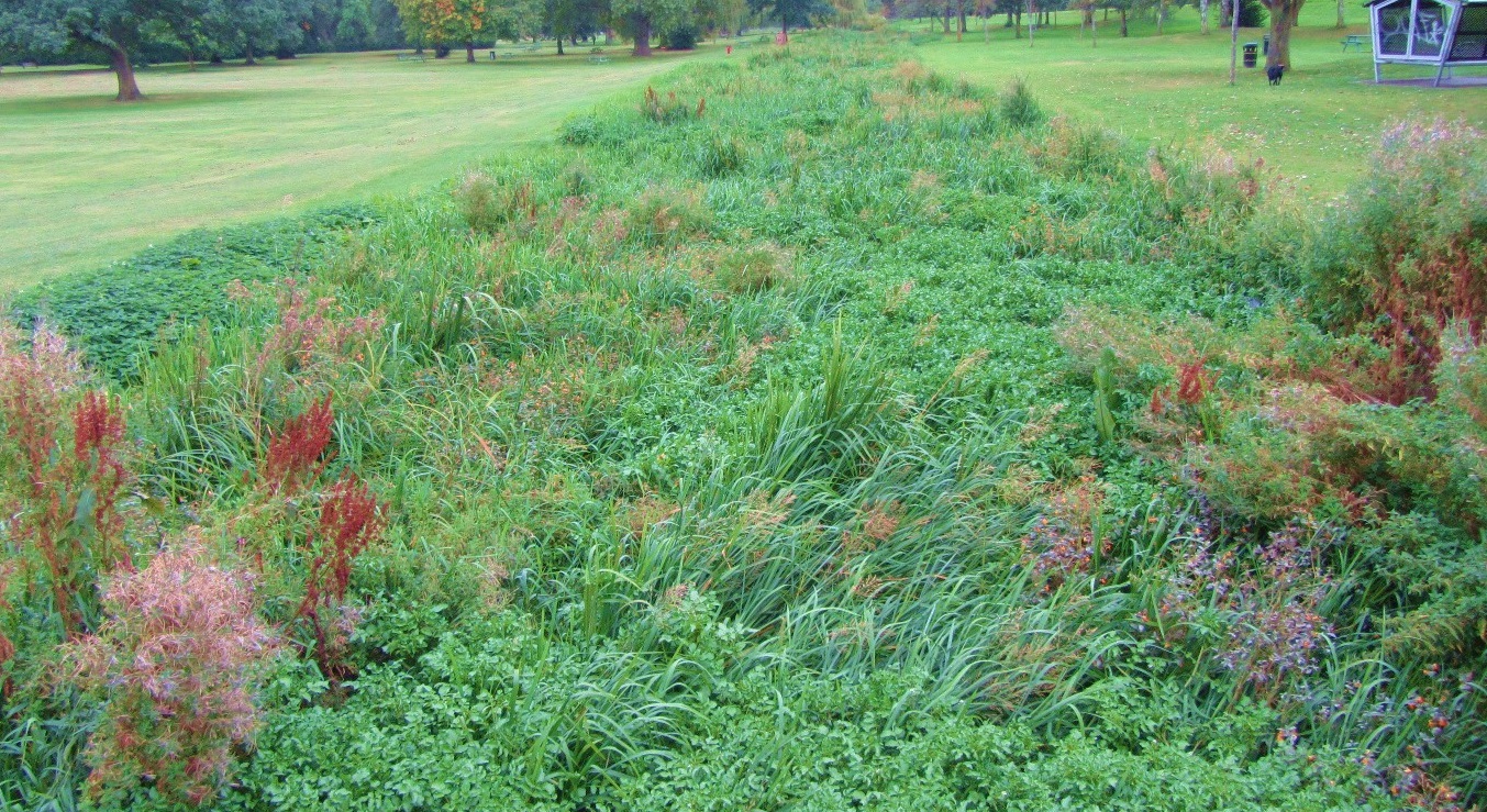 Image 3: Excessive vegetation growth blocking the channel in Gadebridge Park.
The weir at our Bury Mill Gauging Station and other remains of historic in-channel structures act as barriers to fish. These structures can also cause sediment and vegetation to build up, impacting on river habitats and wildlife.
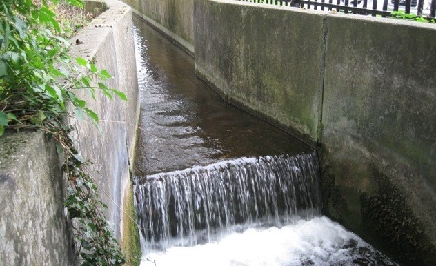
Image 4: The Environment Agency’s Gauging Station. The channel consists of a concrete bed and banks for about 40 metres.
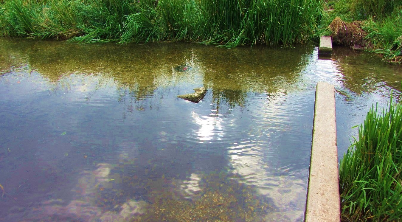
Image 5: Remains of old weirs affect fish movement and cause the build-up of sediment and vegetation.
Low flows
The River Gade often suffers from low flows due to:
- Spring flows (groundwater emerging at the surface) being diverted into an underground tunnel (culvert) rather than feeding the River Gade.
- Being disconnected from the groundwater table (see Image 3). For a chalk stream, where over 70% of its flow is from groundwater, this can have a significant impact on its resilience during periods of low flows and to wildlife in the channel.
- Water being taken (abstracted) for public water supply.
Most water we drink in the South East comes from rainwater stored deep beneath our feet in natural chalk ‘aquifers’. These also feed our chalk streams. In 2018 Affinity Water reduced net abstraction in the Gade catchment by 2,342,400 m3/year (that’s an average of 6.4 million litres a day). However, demand for water in the South East remains high. We all need to reduce the amount of water we use - every drop wasted is water that could be sustaining our rivers, streams and lakes.
Visit https://www.waterwise.org.uk/save-water/ for ideas on reducing your water use to help our chalk streams.
Our objectives
Together with Dacorum Borough Council and Affinity Water we want to:
- Improve the River Gade and the adjacent parkland for wildlife.
- Provide more opportunities, accessible to everyone, for people to get closer to the river and enjoy nature.
- Improve floodplain connectivity, but reduce the impact of flooding – i.e. flood water can be stored on the floodplain when needed, but doesn’t sit on the parkland for long periods of time.
- Improve biodiversity in the River Gade, so that it supports Good Ecological Status under the European Water Framework Directive.
- Improve the river’s resilience – its ability to cope with and adapt to the pressures of low flows, high flows and climate change.
- Reduce the barriers to fish movement and impoundment caused by river structures, including the Environment Agency’s gauging station.
- Improve flows in the river, to lessen the build-up of sediment and vegetation and to reduce the need for maintenance.
- Replace the Environment Agency's gauging station to improve the ability to monitor river flows and provide flood warnings.
- Provide more opportunities to learn about the River Gade, both its historical importance to the landscape and its value as a rare chalk stream.
Our proposals
JBA Consulting carried out an initial feasibility study for Gadebridge Park from 2016 to 2018 in consultation with all project partners and key stakeholders. Based on its results a number of proposals were developed that we consulted the public on from 20 July to 30 September 2018. You can view the submitted responses and our consultation summary report at https://consult.environment-agency.gov.uk/hnl/gadebridge-park-river-restoration/
Our latest proposals include:
- Realigning the part of the River Gade located downstream of the Grade II listed White Bridge back to the valley bottom (through the centre of the park at its lowest point). This will reconnect the river to its floodplain and to the groundwater table below.
- Re-routing spring flows - which are currently diverted through a culvert (underground tunnel) and discharged into a fishing lake at Kings Langley 5km downstream - into the new realigned channel. This will provide additional flow to the river, increasing its resilience to low flows, improve the river’s water quality and help to restore natural characteristics of a chalk stream such as a more alkaline PH and a stable temperature all year round.
- Replacing the existing Bury Mill gauging station with a gauging station on the new realigned channel that is passable to fish and has a reduced impact on the river.
- Creating vegetated riparian margins alongside the river channel and a wildflower meadow, to provide new habitats for wildlife.
- Following a water vole mitigation programme to ensure this species is protected during all phases of the project.
- Providing new footpaths alongside the river, an accessible footbridge crossing the new realigned channel from the Queensway carpark to the Bowls Club and an accessible footbridge in the centre of the park - all for people’s enjoyment of the river.
- Providing an access point next to the river for people to get closer to nature.
- Installing information boards within the park to share the River Gade’s historical importance to the landscape and help people to understand and value our rare chalk streams.
Contact us
For further information about the project please see the documents and links below and check back for updates on this information page.
If you have any questions we will be happy to help:
- Kelly Standbrook* (Environment Agency) gadebridgepark@environment-agency.gov.uk
- Ian Ross (Dacorum Borough Council) biodiversity.wildlife@dacorum.gov.uk
*Please only contact Kelly with questions specifically about Gadebridge Park’s river restoration project. Questions about all other aspects of Gadebridge Park should be sent to biodiversity.wildlife@dacorum.gov.uk
Get in touch...
To share your comments with us or ask a question at any time, please email us at gadebridgepark@environment-agency.gov.uk.
If you would like to join our mailing list to receive future updates for the duration of the project, please contact gadebridgepark@environment-agency.gov.uk with your email address. We will not use your contact details for any other purposes.
We look forward to hearing from you.
Audiences
- Academics
- Community groups
- District and parish councils
- Elected representatives, including MPs
- Environment Agency colleagues
- Environment Agency customers
- Environmental bodies
- Flood action groups
- Lead Local Flood Authorities
- Local authorities
- Local councils
- Members of the public
- Members of the public with an interest in the river, the species and conservation
- NGOs
- Recreational and commercial river users
- Statutory organisations
- Town and parish councils
- Water companies
Interests
- Drought
- Flood management
- Habitats and wildlife
- Specific projects, issues, or activity pages
- Water quality
- Water resources
Share
Share on Twitter Share on Facebook