River Idle
Overview
This information page provides an overview of the River Idle, its history, our current understanding and work, legislation, future work and investigations.
Please use the Fact Banks below to find the sections relevant for you.
Geography of the Area
Geography of the area
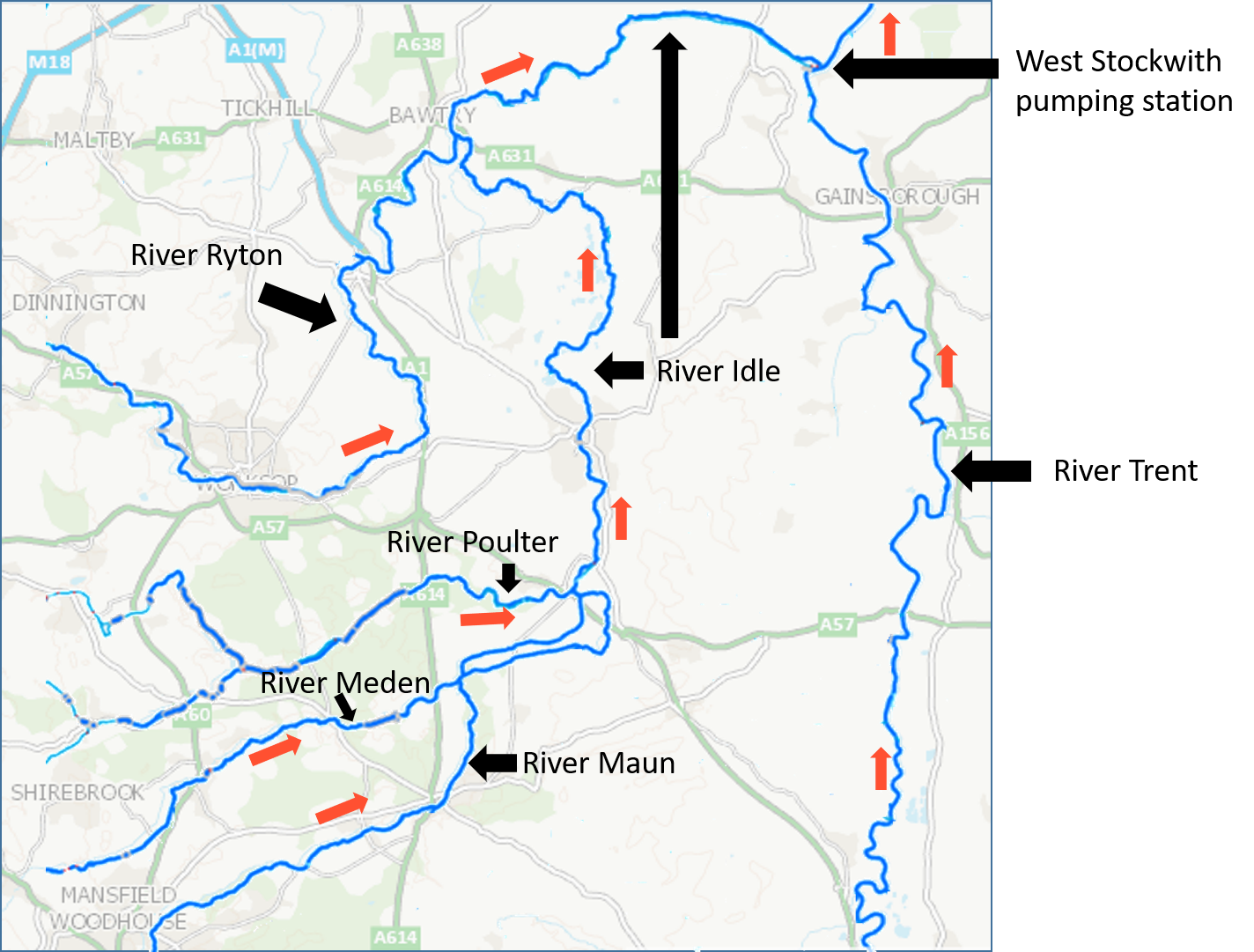
The River Idle is a 30 mile long river in Nottinghamshire. It begins at the confluence of the River Maun and River Meden, near Markham Moor. From there, it flows north through Retford and Bawtry before entering the River Trent at West Stockwith. The Idle originally flowed into the River Don at Hatfield Chase, but was diverted eastwards from Idle Stop (between Misson and Misterton) by drainage engineers in 1628. The river is largely rural in character, although it passes through the centre of Retford and skirts the south-eastern fringe of Bawtry. Land levels vary from 2.4m AOD in the lower reaches to 183m AOD in the south-west of the catchment. AOD stands for above ordnance datum, where the datum is usually the average sea level.
Most of the land surrounding the river is a broad floodplain. Between Retford and Bawtry, the floodplain is partly occupied by a number of old sand and gravel quarry pits; most are now managed as Sites of Special Scientific Interest. Downstream of Bawtry, the river is constrained by flood banks, to allow the low-lying areas to be drained for agriculture. Its main tributaries are the River Poulter and the River Ryton.
The river is important for conservation, with the Idle Washlands and some of the sand and gravel pits of the Idle Valley being designated Sites of Special Scientific Interest.
The catchment for the River Idle covers some 280 square miles (725 km2), which has an average annual rainfall of 24.3 inches (620 mm) (based on figures from 1961 to 1990). About a third of this finds its way into the rivers.
There is a reliance on efficient drainage to support modern day demands on society and infrastructure. In 1980, West Stockwith pumping station was commissioned as part of the River Idle improvement scheme, this allowed the River Idle to be pumped or gravitated into the River Trent at times of high flows in the River Idle and prevented the ingress of high tides and flood water. The River Idle Improvements Scheme was completed in 1982 and comprised a major flood defence and land drainage project. This drained existing washland areas, which are now agricultural land protected against flooding by major and minor embankments.
Within the Isle of Axholme, the river has a very flat gradient and flows through low lying areas, with rich agricultural land. Much of the area relies on artificial drainage through a series of pumping stations, drainage ditches and river channels, flood embankments and walls which operate every day to keep the Isle of Axholme dry. Without this activity carried out by the Environment Agency and Internal Drainage Boards, the area would look very different. Continuing to manage flood risk in the Isle of Axholme is vitally important.
The banks of the river downstream of Bawtry have been raised so that the river acts as a high level carrier for the drainage of the surrounding land. The area around the river is drained by a network of drainage ditches, which are connected to the river by a number of sluices and pumping stations. Water is pumped from the ditches to avoid flooding of the agricultural land.
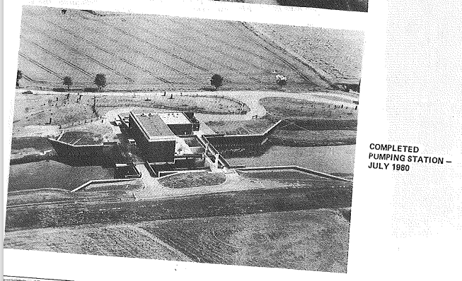
The majority of the land in this area lies below the Trent high tide level and because of this it relies on efficient drainage to support a high standard of agriculture. Since the early 1600's, works of reclamation and land drainage improvement have been a continuing process. The outflow into the River Trent is controlled by a pumping station and two sluices. A vertical sluice gate protects the entrance to the Idle, and the pumping station and another sluice are situated further back. When the water level in the Trent is low, the sluice gates allow water to leave the Idle by gravity, but at high tide during a flood event, four electric pumps are used to pump the outflow into the space between the sluice gates until it can again discharge by gravity. The pumping station was commissioned in 1981, and was the largest all-electric pumping station in Britain at the time. When all four pumps are operating, it can discharge 2,124 tons per minute.
A number of the flood defences and pumping stations in and around the Isle of Axholme are nearing the end of their lives and continuing to manage flood risk in this area will require a significant increase in investment both now and in the future. Recognition of this fact led to the production of a flood risk management strategy (FRMS) for the Isle of Axholme area in 2013 – a 100 year plan that sets out how we should adapt, improve and generally prepare the area for dealing with the risk of flooding. The purpose of the Strategy is to establish how best to manage flood risk in the Isle of Axholme in the coming years in the context of the community’s wider social, environmental and economic aspirations for the area, with objectives covering cost effective approaches for land drainage and flood risk management, resilience in the face of extreme events and/or future change, environmentally sustainable flood risk management, fulfilling biodiversity requirements and gaining understanding and support of key partners and the wider community.
Live river level data:
History of the river and catchment
History of the river and catchment
The River Idle floodplain is known to have Bronze Age, Iron Age and Roman settlements. There are important archaeological sites at Newington and Misson, and there is evidence to suggest a Roman presence at Bawtry village.
Until the 17th century, the river flowed northwards from a place which subsequently became known as 'Idle Stop', and continued to join the River Don to the north west of Sandtoft. However, in 1626 the Dutch drainage engineer Cornelius Vermuyden was appointed by King Charles I to drain Hatfield Chase, which was completed two years later. The Idle’s course was blocked by a dam constructed at Idle Stop and its waters were diverted along the Bycarrs Dyke, a Roman navigation channel, which joined the River Trent at West Stockwith.
Joan Thirsk in 1953 wrote about the Isle of Axholme before Vermuyden. “The common pasture was intersected by natural creeks and man-made dikes, serving to drain away the surplus water. Burnham Skiers was an example of a natural creek which separated Burnham’s open fields from Haxey North Carr…” “Dikes, sewers and rivers provided waterways all over the isle. The main traffic routes… … were the river Idle, Bickersdike and the river Trent…” “In Winter the waterways multiplied and widened and provided an excellent system of communications…” “Much of the commons, of course, lay underwater in winter from Martinmas (November 11) till May Day. But this was not all loss. As the inhabitants of Epworth informed the king’s commissioners, too late to undo Vermuyden’s work, the floods brought with them ‘a thick fatt water,’ which enriched the ground, and enabled it to support large numbers of cattle, sheep, and pigs in summer.”
More information can be found at Drainage of the Isle - axholme.info
Flooding History
Flooding history
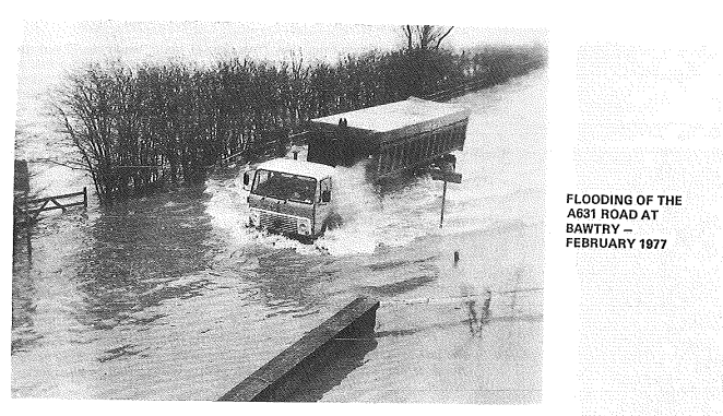
There has been a long history of flooding of the Idle. In the past when the Trent was in flood, water could not discharge from the Idle. Consequently the lower reach of the Idle to the confluence with the River Ryton acted as a receiving pond for water draining from the higher part of the catchment. On such occasions, as the water level rose in the Idle, hundreds of acres alongside the river become inundated. The longer the period when discharge to the Trent was prevented the higher the level of ponding in the lower reach of the Idle. To contain this flooding to recognised washland areas, a system of major floodbanks were constructed on both sides of the river which links to high grounds. These floodbanks, located between West Stockwith and Bawtry, have had to be continually strengthened and raised to maintain critical flood defence levels. The main flood event was the March 1947 flood when over 2,000 hectares of agricultural land in the Derton area was flooded, to an average depth of 1.2 m. It took 2 months to dewater the flooded land. As recently as February 1977, when floodwater in the Trent maintained high levels for several days and no discharge from the Idle was possible, the level came within 225 mm of overtopping the major banks. Some of these defences stand over 3 m above agricultural land.
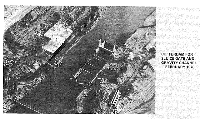
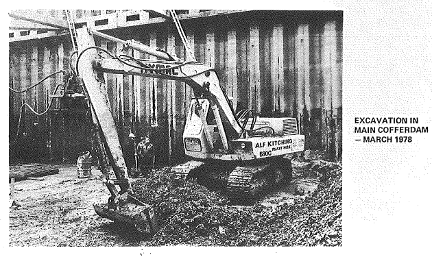
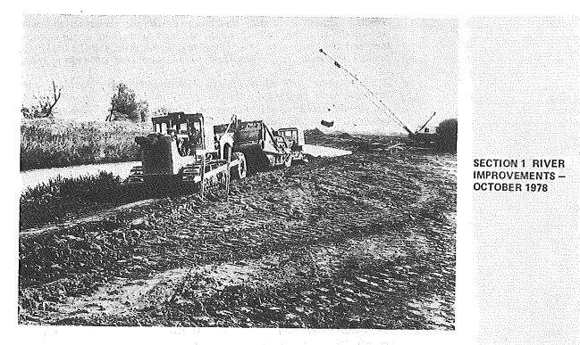
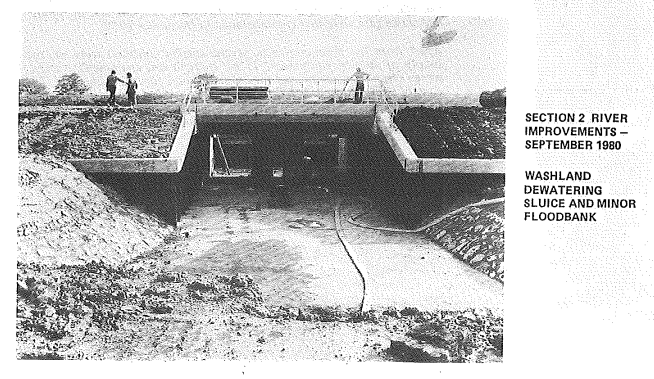
A feasibility study of the Idle drainage was undertaken by the Trent River Authority and culminated in the production of a report in 1974 which suggested pumping the Idle at West Stockwith. The study indicated that there was economic justification for a large pumping station and river improvements. The scheme received the approval of the Water Authority's Land Drainage Committees and also the Minister of Agriculture, Fisheries and Food. The estimated cost of the scheme, as outlined in the Supplementary Report, was £12 million (April 1974 prices) to give the once in 50 year (2% in any given year) standard of protection. The pumping station was constructed between 1977 and 1979 while the river improvements were carried out between 1978 and 1982.
Consultations took place with land owners, angling clubs, conservationists, boat clubs and the National Coal Board. Attention was given to various means of improving access to the river for routine maintenance and flood emergencies.
To assist anglers, berms were constructed at suitable levels, together with the formation of "fishing holes" in the river bed. At the Bailey Bridge, near Idle Stop, concrete ramps were constructed down the river bank together with stone and timber platforms at the water’s edge to enable wheelchair access.
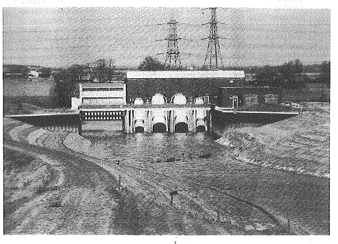
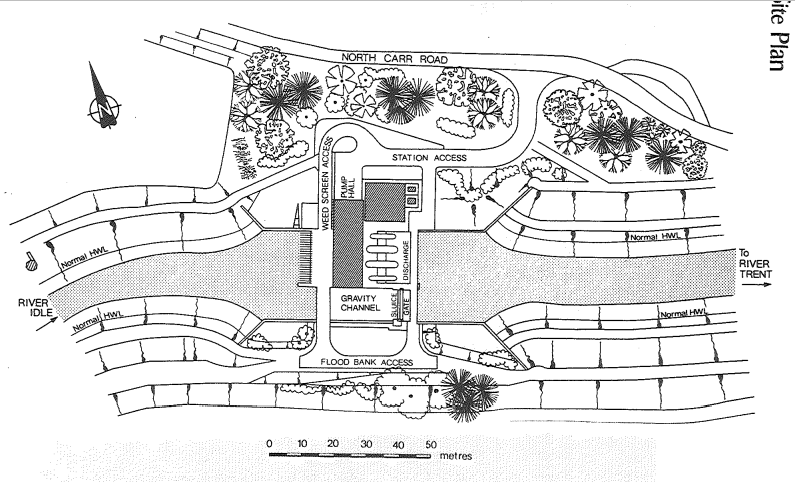
The river levels are now controlled by the operation of West Stockwith Pumping Station, which was formally opened in July 1981 and designed as an integral part of the “River Idle Improvement Scheme”. Adjacent to the station there is a gravity channel for the River Idle, controlled by a vertical lift sluice gate 9 metres wide and 7 metres high. At the outfall of the River Idle is the original sluice which controlled the discharge of the Idle into the River Trent. These two sluices are now linked by sensors located in the River Trent and River Idle and are used to maximise the gravity discharge of the Idle into the Trent. The pumps are brought into use only during adverse conditions.
Misson washlands are used to store flood water in high flow events to allow the pumpstation at West Stockwith adequate time to pump. Previously, large parts of these washlands were permanently inundated from December to May most years.
The River Idle, at Mattersey, has not fallen below 0.591m since November 2012, following the driest summer/winter in recent memory. The average river level on the River Idle at Mattersey in the last 9 years is approximately 1.16m.
We operate our assets, namely West Stockwith Pump Station, in agreement with the Water Level Management Plan (WLMP). The Pump Station is automated to operate when the relevant triggers agreed in the plan are met. The pump station has operated without issue and fully in accordance with Table 6.2 of the WLMP since winter 2019. In 21/22 we pumped at winter levels to try and proactively lower the levels. The WLMP, written in 2006, had a light touch in 2019, and was approved by Natural England and the Environment Agency in consultation with the River Idle Management Partnership (RIMP).
Storm Babet and Henk
Heavy, persistent and widespread rain affected much of England, Wales and Northern Ireland from 18th to 20th October 2023, with 100mm falling fairly widely. This was the third-wettest independent 3-day period for England and Wales in a series from 1891, while the Midlands provisionally recorded its wettest 3-day period on record. This rain came on top of very wet weather earlier in October with some central and eastern parts of England and Scotland recording more than twice the October whole-month average rainfall in the first three weeks of the month.
Storm Henk, the eighth storm of the 2023-2024 storm season, brought damaging winds and heavy rain to southern and central parts of England and Wales on 2 January 2024. Winds gusted widely at over 50Kt (58mph), even in inland locations. Heavy rain from storm Henk contributed to significant flooding problems, following the wet weather during autumn and December 2023. Between 1 October 2023 and 4 January 2024, parts of the East Midlands, north-east England and eastern Scotland received more than 150% of the 1991-2020 long term average rainfall for the four-month period October to January.
Storm Babet caused record levels on the river Idle with the Ordsall gauge recording 1.79m on the 22nd October.
Groundwater
Groundwater
The importance of groundwater as a strategic resource
Groundwater is the naturally stored water in porous and fractured rocks called resource in groundwater bodies and given their vast scale sometimes these are subdivided into smaller groundwater management units. Each aquifer has inherently diverse hydraulic properties which affect how water is stored and moves through the natural water cycle. The EA designates aquifers based on their ability to supply groundwater as a resource and its role in supporting surface water flows and wetland ecosystems. The aquifer designations1 are: Principal Aquifer, Secondary Aquifer (A, B, and Undifferentiated), and Unproductive Strata.
Groundwater roles in the River Idle catchment
Groundwater is a key contributor to the health of the River Idle catchment. It provides natural river baseflow to most of the surface watercourses and supports levels in groundwater fed wetlands across the catchment (Fig. 1). Groundwater levels fluctuate seasonally in response to rainfall although due to the aquifer properties, typically the seasonal patterns are delayed and therefore not necessarily aligned with the more reactive surface water regime.
The groundwater also has a significant role in influencing surface water quality, affecting the levels of potential contaminants such as nitrates, phosphates, pesticides and fertilisers, amongst others.
As climate change progresses, the role of groundwater becomes vital for the River Idle Catchment and its abstractors, especially during prolonged dry weather periods, as it sustains low river flows and water dependent habitats.
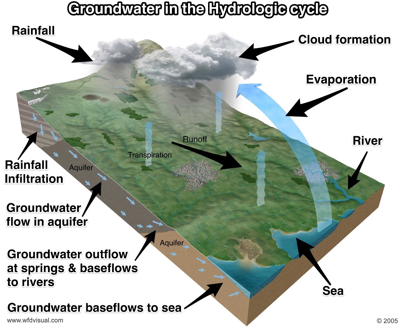
Fig. 1 Groundwater in the hydrological cycle (from wfdvisual.com). This diagram displays the interaction of groundwater with surface. Groundwater is recharged by rainfall and flows across the different aquifers and ultimately reaching the discharge zones (i.e. outflowing at springs, baseflow to rivers and sea).
Aquifers of the River Idle Catchment
From west to east, the River Idle catchment is underlain by the following outcropping aquifers: the Coal Measures, Magnesian Limestone, Sherwood Sandstone, and Mercia Mudstone. These aquifers regionally extend at the surface in a north-south band fashion and dip slightly eastwards where they become confined beneath the overlying geology (Fig. 2). Additionally, where present, river sands and gravels Superficial Deposits provide a local but limited source of groundwater and in some areas may be hydraulically connected to the underlying aquifer.
Coal Measures (Secondary A aquifer): The small portion of the aquifer within the River Idle catchment may provide source of water to small private abstractors and baseflow to support the headwaters of the River Meden and River Ryton catchments.
Magnesian Limestone (Principal): This important principal aquifer provides a sustained source of water to agricultural abstractors and baseflow to support the headwaters of many of the River Idle catchment’s rivers.
Sherwood Sandstone (Principal): Of strategic importance, the Sherwood Sandstone aquifer provides large parts of Nottinghamshire and surrounding areas with drinking water supply, crop irrigation, and industry water needs amongst many other purposes. As detailed below, this aquifer is the most significant for the Idle catchment.
Mercia Mudstone (Secondary B): Although the Mercia Mudstone is considered regionally as the confining formation to the Sherwood Sandstone Principal aquifer, it may supply water at a local scale if the right water-bearing strata is targeted.
Superficial Deposits (Secondary range): Limited in areal extent in incised valleys (e.g. in the Maun and Meden vales) and extensive in low-lying flat basins (e.g. the River Idle near Bawtry), the Superficial Deposits supply water at a local scale and become a key source of water to water-dependent ecosystems.
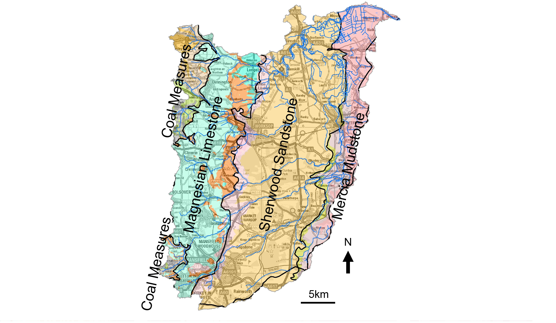
Fig. 2 River Idle catchment’s underlying bedrock geology map. This figure displays the River Idle catchment river network (thin blue lines) cutting through an overall North-East direction the underlying groundwater bodies (thick black outlines).
The role and pressures of the Sherwood Sandstone aquifer
From the aquifers named above, the Sherwood Sandstone is the most significant for this part of the country at both local and regional scale. Stretching from south of Nottingham to further north of York, the aquifer supplies drinking water via abstraction boreholes to millions of customers. The land use in the River Idle catchment within Nottinghamshire is widely agricultural, for which groundwater supplies a big proportion of crop irrigation needs. Industry continues to be a part of the groundwater share in the Midlands in the form of food processing and quarrying, The Sherwood Sandstone of the Midlands suffers from historic over-abstraction due to a combination of public water supply, industry water needs and agriculture purposes. The needs of abstraction for industrial uses have slowly reduced during the past decades. However, over-abstraction continues to pressure the Sandstone and it remains at poor environment health under the Water Framework Directive assessments. Groundwater over-abstraction reduces the short and long term water resource resilience for both the environment and water users.
The coal industry’s legacy has changed the River Idle catchment characteristics. Although the industry declined over the past decades it left remnants. The EA and the Coal Authority continue to work on some of the problems involving minewater quality, subsidence, and low flows.
Climate change
Global warming is resulting in climate change at a world scale. Climate change impacts on groundwater resources in the Idle Catchment are especially noted in the form of more acute and frequent prolonged dry weather periods. This results in the reduction of wet months spread over the year and higher temperature readings over a wider time period2 which add pressure on groundwater and surface water abstraction. Although total rainfall is thought not to change significantly, it will happen over a shorter period of time which means more frequent flooding but also a reduced yearly aquifer recharge and groundwater baseflow to rivers and wetlands. Therefore, our groundwater-surface water system sees an additional pressure that affects the resource resilience for the environment and abstractors. Recent examples are years 2016, 2018, and 2020, where prolonged dry weather periods stretched the licenced resource of water users and impacted the recovery of our aquifers.
Environment Agency’s groundwater evidence tools
The EA owns several evidence tools in order to manage and prepare water resource plans and strategies. The Idle Catchment benefits from a Groundwater Model which collates the best understanding of the catchment and calibrates it against real groundwater level monitoring and surface water flow gauging data to produce as accurate modelled level data as possible.
The River Idle Catchment is part of the Idle and Torne Abstraction Licence Strategy3, which outlines the water resource availability.
Ongoing work
The EA is the regulator of the water environment for England. We must ensure that each water abstraction and discharge is sustainable at both local and wider catchment scales. Therefore we undertake periodic catchment scale reviews to assess the current status of our aquifers and surface waters. We produce plans and strategies to work with abstractors in order to achieve a sustainable abstraction approach.
The Water Industry National Environment Programme is an example of current and iterative work in which EA requires a set of actions, within a timeframe, to all 20 water companies in England in order to contribute towards meeting their environmental obligations under the Water Framework Directive.
We produce the Abstraction Licence Strategies which set the water availability in each catchment. These are reviewed and actions taken to improve environment resilience.
Biodiversity and habitat
Biodiversity and habitat
The presence of birds, along the river valley, makes bird watching an important recreational activity in the river valley. The river is also fished on both banks upstream and downstream of Bawtry.
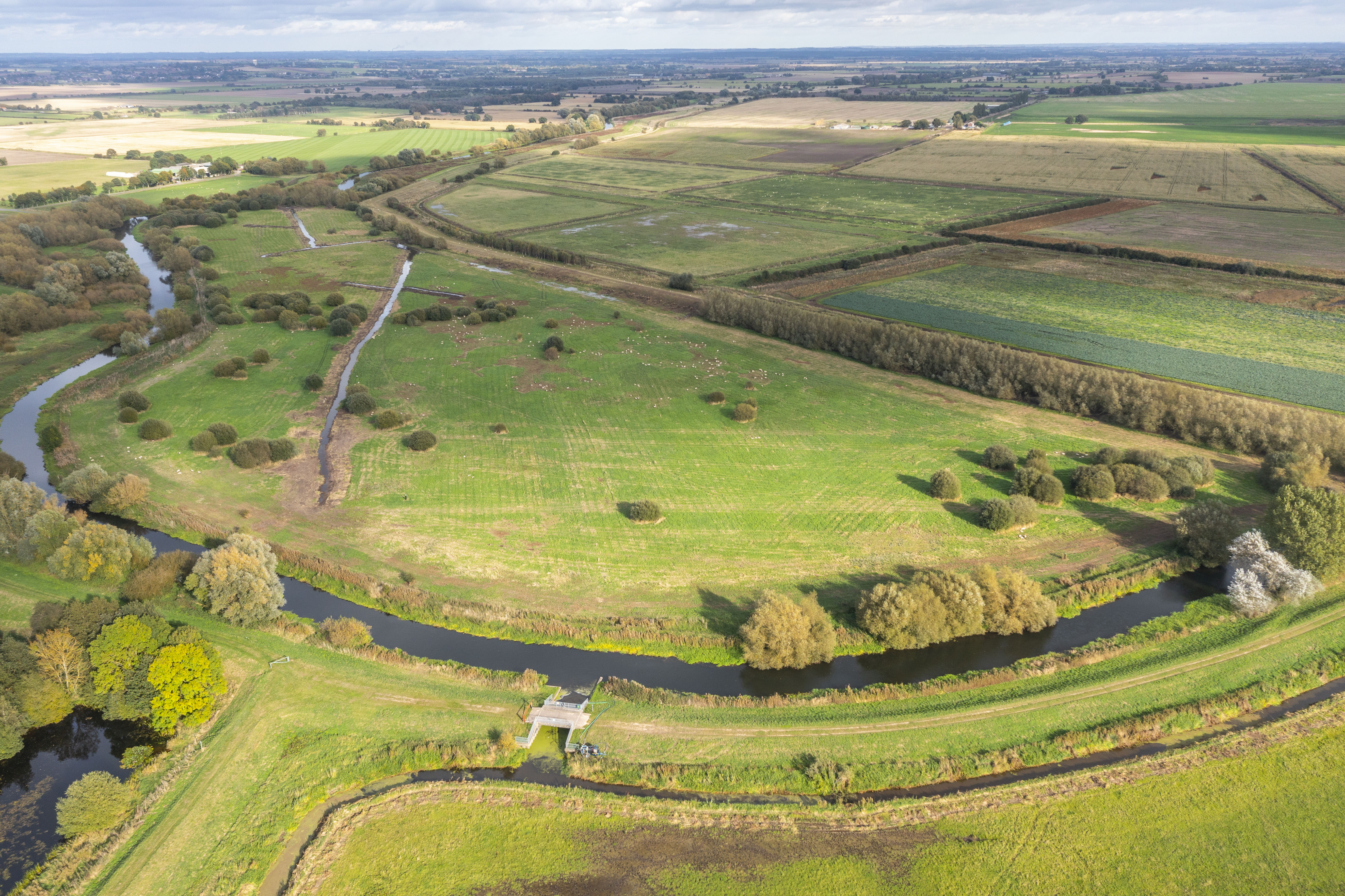
There are four areas of grassland adjacent to the lower Idle which are subject to periodic flooding and provide habitat for wintering and breeding birds. They form the Idle Washlands Site of Special Scientific Interest (SSSI), which is made up of four geographically distinct units of washland, all below the high tide level of the River Trent. These sites are at Bawtry, Misson West, Misson East and Idle Stop. The principal habitat of all units are floodplain grazing marsh, which includes areas of dry and wet grassland, open water, swamp and fen. Historically, a much greater area would have worked in this way, but much of it is now separated from the river by major & minor floodbanks that provide 1 in 50 and 1 in 3 year protection to the surrounding farmland and communities. The Washlands SSSI once covered an area of 246 hectares, which was used for grazing during the summer months, with plant species such as great water parsnip, marsh valerian, yellow loosestrife, meadow thistle, blunt-flowered rush, purple small-reed and reed sweet grass. These lowland meadows were home to breeding lapwing, snipe, curlew and redshank. Every winter, the River Idle overtopped its banks, which flooded the grassland and attracted large numbers of Bewick’s and whooper swans, averaging 80 Bewick’s in most winters. In 1971 as many as 174 birds were recorded, giving the washlands a status of international importance. During the 1980s, further flood defence work and land drainage reduced the washland area to 88 hectares. The SSSI on Misson East, one of the lowest washlands, was reduced from 69 hectares to 4.8 hectares. The number of swans dropped to 17 in 1981-2, and finally to none at all the following winter. Unfortunately the retained areas were not large enough for birds to settle securely without disturbance.
Assessment of the SSSI in 2004 found that the Flood Alleviation Scheme caused changes in the washlands including that the depth of surface flooding, frequency of flooding and duration were all reduced. The washlands were predicted to flood once in three years, whereas previously they were inundated annually. The gradient from river to washland changed, so overtopping to the washland was reduced. Soil saturation reduced and soil moisture deficit increased. Groundwater levels were affected by reduced water filtering through the soil and reduced flow from the river, and lowering ground water impacted surface wetness by removing support of the surface saturated layer.
The Environment Agency and Natural England are working with local landowners to make improvements to Unit 4 SSSI; changing the land management practices to improve the site for wetland bird species. The initial results are encouraging, but we are still at the start of the process for bringing the site back into favourable conservation status. The National Environment Programme is funding further work across the catchment to ensure that the wildfowl and wader habitat is not lost completely. The Environment Agency has produced a water level management plan to further protect the SSSI. Since the November 2019 floods, there has been a resurgence in the numbers of overwintering wildfowl and wading birds, attracting a migration of ornithologists into the area.
An image of the unit 4 SSSI, courtesy of Pollybell Farm.
The Idle Washlands have been identified as a priority site for achieving appropriate water level management, balancing and integrating the water level requirements for a range of activities within the SSSI. These activities include agriculture, flood risk management and conservation. The key to improvement in the condition of the habitats is regular inundation and standing water through the winter and a high water table throughout the year.
These conditions are not maintained under the current management system. A complex combination of the impacts of the River Idle Improvement Scheme, land management and water abstractions have been suggested as causes of the unfavourable condition of the SSSI.
In washland environments the primary control on site wetness is flooding and retention of rainwater. Floods of the washland have become less frequent and prolonged following flood defence works. Water loss is influenced by agricultural drainage. If water levels in adjacent fields are managed below the washlands this can cause water loss. Parts of the Idle Washlands also lay above the Sherwood Sandstone, which is a major aquifer and is regionally important as a drinkable water supply. The groundwater table shows a decline from the 1960s to the 1990s which reflects the development of the Sherwood Sandstone aquifer for public water supply. Sites above the Sherwood Sandstone, such as the SSSIs, have been predicted to be vulnerable to groundwater level decrease.
The complex nature of the ground levels leads to variable response to changing conditions, such as flooding or recessions in the washlands. In some areas the ground characteristics will impede drainage and potentially achieve a high water table and standing surface water, which will improve the habitat. The need to get water onto the washlands and then to ensure that it remains there, on the surface and at shallow depths, is critical to improving the condition of the SSSI. It is also vital for these conditions to be maintained over a period of time.
Prior to the flood alleviation works, water entered the wetland system through rainfall, over bank flooding and year round groundwater flows. The adjacent floodplain probably had a high water table and standing water flowed gradually back to the river. The River Idle was deepened as part of the flood alleviation works, reducing the river water level and reducing the frequency and volume of over bank flooding. The recovery of groundwater levels in surrounding areas has not been at the rate anticipated. It has been shown that the flood alleviation works are not the sole or primary cause of the degradation of the wetlands, and historic climatic factors and groundwater abstractions also need to be considered.
In post-war years, counts of over 100 Bewick’s swan, flocks in the region of 500 to 900 wigeon, 500 teal, 1,700 pochard and significant numbers of golden plover, black-tailed godwit, lapwing, snipe, redshank and curlew were a regular occurrence along the river. Birds of prey such as hen harrier, merlin and short-eared owl were also regular in winter, whilst snipe, curlew, lapwing and redshank bred in reasonable numbers in the spring and summer months. Other wildlife interest associated with the river itself, the washlands and wet ditches included otters, water voles, dragonflies, damselflies, water beetles and a variety of aquatic plants.
Since the 1982 River Idle Improvement Scheme, much of the washlands have been drained and now no longer receive regular, shallow winter flooding. The landscape has also become increasingly dominated by arable farmland. Unfortunately, these changes mean that the bird and wildlife interest of the area has diminished. Some bird species, such as Bewick’s swan, are now forced to utilise areas nearby, such as Misson Springs to the north, an area only remaining relatively wet due to former mineral extraction operations and the resulting drainage problems.
Further upstream, some 316 ha of the Sutton and Lound gravel pits have been designated as a SSSI since 2002. Part of the quarry was sold to the Nottinghamshire Wildlife Trust in 1989, and after years of restoration work, the SSSI designation was achieved. It is now known as the Idle Valley Nature Reserve. The Trust was given further land in 2009 as quarrying operations wound down, and the reserve was extended again as additional land was acquired. When a disposal plant was closed in the 1990s, the settling lagoons also became part of the reserve. A total of 450 ha are now managed by the Trust, making it one of the largest nature conservation sites in the East Midlands.
The pits provide an important wetland habitat for a large variety of birds. A total of 172 different species of birds were recorded in 2008, a number of which are normally found near the coast rather than at inland sites. These include ringed plover, little ringed plover, shelduck and oystercatchers. Recording of birds at the site has been taking place since 1951, with 271 distinct species having been identified. The reserve also provides habitat for smaller animals, including 600 species of moth, 28 species of butterfly and 19 species of dragonfly.
The River Idle downstream of Bawtry varies in habitat structure but is predominantly typical of a lowland river. The fish density distribution is not equal across this stretch, with Bawtry being the site with the highest fish density and species diversity. Species confirmed as being present on this stretch in recent years are perch, roach, dace, chub, gudgeon, pike, eel, flounder and bleak. One adult salmon has also been caught at the Bawtry site. The margins offer the best fish habitat within the river where aquatic plants and overhanging trees provide some structure. However, in-stream fish habitat is generally poor, largely due to the absence of a pool-riffle structure, though submerged plants do provide some additional habitat interest. The Environment Agency have also had reports of invasive species along this section of the River Idle between West Stockwith and Bawtry, including the American signal crayfish and Chinese mitten crab.
The impacts of climate change will play a significant role in affecting the water levels in the washlands. The UK Climate Projections 2018 shows that there has been an increase in annual average rainfall over the UK during the most recent decade (2008-2017), which has been on average 4% wetter than 1981-2010 average. Summers in the UK, for the most recent decade (2008- 2017), have been on average 17% wetter than 1981-2010 and 20% wetter than the 1961-1990 average. Average sea level around the UK has risen by about 16 cm since the start of the 20th century (when corrected for land movement) (UKCP18).
We have also invested substantial funds to a partnership project with Nottinghamshire Wildlife Trust to improve conditions at the Idle Washlands SSSI over a 2 year period (2020-2022).
Water Framework Directive (WFD)
Water Framework Directive (WFD)
The WFD is a piece of European legislation aiming to protect and improve the water environment. The legislation, adopted by the UK in 2000, replaced and superseded a number of existing National and European directives. In 2017 WFD legislation was transposed into UK law under the Water Environment Regulations (WER).
WFD requires the production of River Basement Management Plans (RBMPs) on a 6 yearly basis. These plans set out objectives and intervention measures to protect the water environment during the cycle. RBMPs are developed for ‘management catchments’ based on geography/ hydrology rather than political / administrative boundaries. For practical assessment / management purposes the catchments are divided into waterbodies.
The River Idle sits within the EA’s Idle & Torne Management Catchment, covered by the Humber RBMP. There are approximately 30 static and flowing surface waterbodies in the catchment.
The tables below compare classification status for surface water bodies in the Idle catchment at the end of Cycle 2 (2016) and the beginning of Cycle 3 (2019).
Table 1: Ecological and chemical classification for surface waters | 2016 Cycle 2:

Table 2: Ecological and chemical classification for surface waters | 2019 Cycle 3:

Table 3: Ecological and chemical classification for surface waters | 2022 Cycle 3:

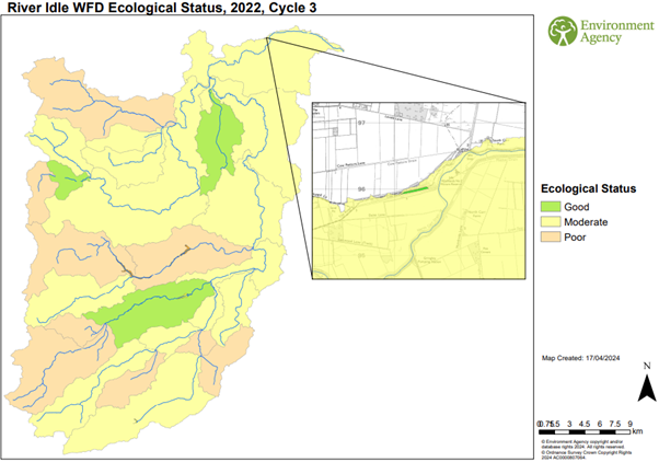
Comparison of Tables 1 and 2 indicate a slight improvement in ecological status /potential with four (13%) rather than two (6%) water bodies being classified as good in 2019. Nationally 6% of water bodies were classified as having good ecological status / potential in 2016 and 2019. The 2022 classifications show there to be no change in ecological status of the River Idle catchment in comparison to 2019.
The increase in the number of water bodies failing the chemical status assessment after 2016 is due to a change in the assessment process rather than actual changes in water quality. Due to these changes, all water bodies now fail chemical status, and this assessment is not comparable to previous years assessments.
In individual water bodies numerous ecological, chemical, hydrological and morphological ‘elements’ are assessed to determine the overall water body status. Tables 3 -5 show an example of a water body assessment.
Assessments are made by collecting samples / undertaking surveys. The results of these samples / surveys are compared with ‘expected’ results determined by computer modelling. The modelled results are based on the physical characteristics of the water body. ‘Expected’ results represent what should be present in the samples if there were no pressures acting on the water body.
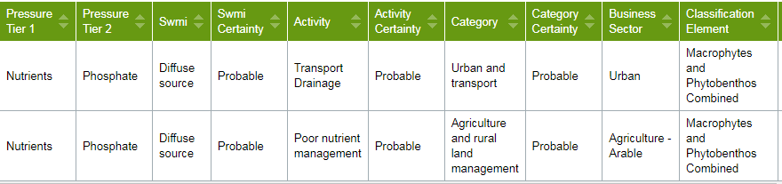
Table 3: Overall water body WFD classification. Example for water body GB104028058091 – Idle from Maun / Poulter to Tiln.
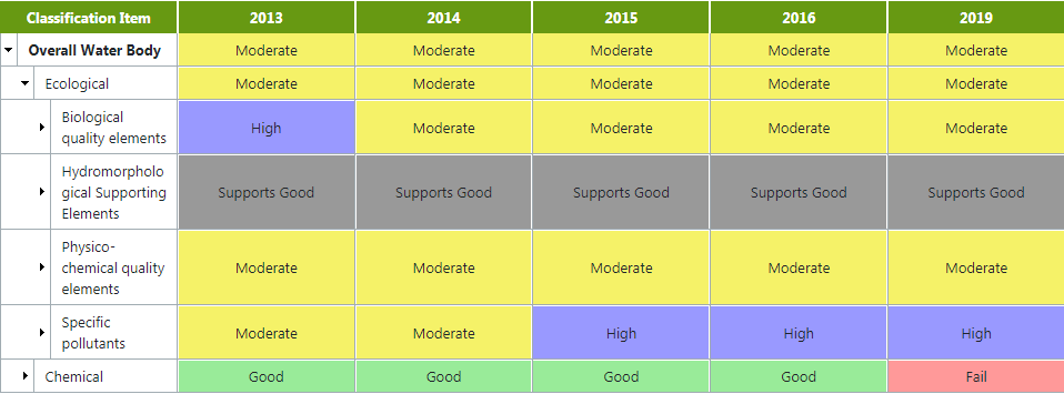
Table 4: Ecological classification for water body GB104028058091 – Idle from Maun / Poulter to Tiln.
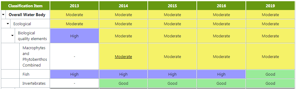
The overall water body classification (moderate) is determined using a principal known as ‘one out all out’. With this principal the lowest ‘element’ classification determines the overall classification. In this example ecological classification is moderate because the macrophyte / phytobenthos (plants and algae) ‘element’ is classified as being moderate even though fish and invertebrates (aquatic insects) are classified as being high or good.
Investigations are undertaken to determine why a particular ‘element’ has failed and what can be done to improve the ‘element’ classification. In this example monitoring has shown that phosphate also fails to achieve ‘expected’ levels in the water body. As Table 5 shows phosphate has consistently been classified as achieving poor classification.
Table 5: Physico - chemical classification for water body GB104028058091 – Idle from Maun / Poulter to Tiln.
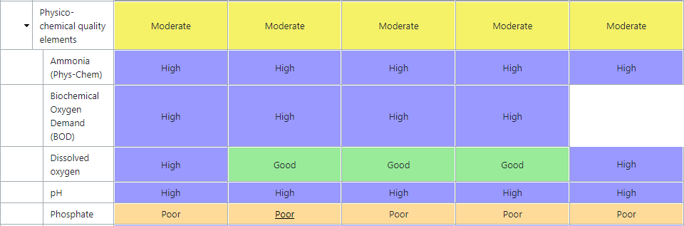
As the amount of phosphate in the water is known to be a limiting factor in freshwater plant / algae community development it seems likely that the two failures are linked. In this case a high phosphate load is allowing a plant / algae community to develop which has more nutrient tolerant species or an overabundance of nutrient tolerant species compared with the ‘expected’ plant / algae community in un impacted conditions.
In this example investigations suggested that the following Reasons for Not Achieving Good (RNAGs) are probably causing the plant / algae community to deviate from the ‘expected’:
Table 6: RNAGs assigned to plant / algae failure in water body GB104028058091 – Idle from Maun / Poulter to Tiln.
Once RNAGs have been assigned resource (guidance / funding) can be put in to trying to improve ‘element’ classification to good. These RNAGs are also under review this year to help us understand whether they are truly still reasons for the failures. These improvements are required under environmental law and help contribute to the EA’s new Environmental Improvement Plan. The plan sets out a framework of strategic goals to provide an environment with clean and plentiful water Environmental Improvement Plan 2023 - GOV.UK (www.gov.uk) . This plan supersedes the 25 Year Environment Plan.
The tables used in the example above have been copied from the EA’s Data Catchment Explorer which provides WFD information for all water bodies in the Idle & Torne catchment England | Catchment Data Explorer . The new Cycle 3 data is now available and can be viewed on the same link above. There will be further updates to this in 2025.
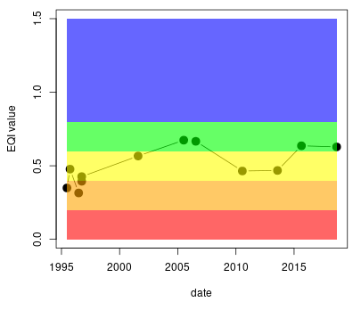
Repeat monitoring enables long term trends in ecological and chemical quality to be identified. The example below shows how the plant community in the River Idle at Misterton has changed in recent years. The graph shows an overall improving trend, in WFD classification, in the plant community (currently classified as being good (green segment of the graph) after a period of being classified as being moderate (amber segment) between 2010 and 2015).
Figure 1: Graph showing WFD classification for the plant community in the River Idle at Misterton (1995 – present).
Monitoring also enables ecologists to build up a picture of species which make up freshwater insect and plant communities. The upper tributaries in the catchment (rivers Poulter, Meden and Ryton) are among the few areas in the country where conditions are suitable for Saucer Bugs (Aphelocheirus aestivalis) and Short leaved Water Starwort (Callitriche truncate) to form part of these communities.

Photograph of Aphelocheirus aestivalis (saucer bug)
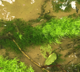
Photograph of Callitriche truncate (short leaved water starwort)
Maintenance Work
Maintenance work
Latest Maintenance Update (Nov 2024):
Our typical annual maintenance programme may include:
Winter – Treeworks to improve conveyance and removal of flood debris from the banks
Spring - Weed spraying and outfall maintenance
Summer – Weed cutting and grass cutting
Autumn – Full inspection of all assets and tree work preparation
Our current maintenance regime is dictated to us by DEFRA policy, this outlines how much funding is attracted to rural areas such as the River Idle - with the most money being allocated to people and property. We undertake the maintenance we are funded to complete under DEFRA guidelines. At this time, the local team are maximising the amount of funding we can allocate to this catchment. Our maintenance is in line with the approved WLMP and English Legislation for ecology. We have to undertake this maintenance under the guidance of our Biodiversity & Geomorphology and Fisheries teams to ensure our work does not cause environmental harm and we adhere to environmental legislation. We have also previously altered our maintenance routine based on input from others. For example, the area around Misson is home to grass snakes. We have delayed the start of our grass cutting season to the warmer months, enabling the snakes to become more active and avoid harm.
Surveys and investigation are carried out every 10 to 15 years to determine whether de-silting work is necessary, but this time scale can be modified due to either long periods of low flow or following periods of flooding. Historical evidence indicates that siltation has always been a problem in this section of river. Removal of debris from bridges and structures on the watercourse is undertaken in the event of high water and West Stockwith Pumping Station is operated as necessary.
Periodic inspection of the watercourse including flood defences is carried out to identify any necessary work requirements. Pest control and the filling of holes in the floodbanks caused by rabbits, moles and rodents is normally carried out three times a year or as required. To avoid obstructions to flood flows it is necessary to maintain trees and bushes and cut vegetation, and this is undertaken approximately once every three to four years. Checking, cleaning and painting of the flap valves is carried out routinely.
The majority of the floodbanks are mown three times a year, on average, using an AEBI ride-on mower or a tractor mounted long arm. Inaccessible areas are cut with pedestrian mowers and rough vegetation with motor scythes. Some relatively short lengths between Newington and Misson are grazed and, on average, these require only one annual cut. The section of major south embankment from Debdhill Farm at Haxey Gate to opposite Misson is not cut until late August. This provides a valuable undisturbed wildlife habitat throughout spring and summer. Re-seeding of damaged areas of turf on floodbanks is carried out as necessary.
West Stockwith Pumping Station
West Stockwith Pumping Station
As the River Idle discharges into the tidal reach of the Trent, it is necessary to maintain a sluice gate to prevent high tides, flood flows and silt from the Trent entering the River Idle. The sluice gate automatically opens (normally twice a day) to allow water to discharge from the River Idle into the Trent at low water level.
The prime function of the automatic control system is to control the Trent/Idle sluice gate, the sluice gate at the pumping station, the pumps and the discharge of water from the River Idle to the River Trent with minimum use of the pumps. To perform these functions the system is equipped with remote continuous water level measurement in the River Trent and River Idle at four locations. These levels are transmitted to the pumping station and used to control the operations.
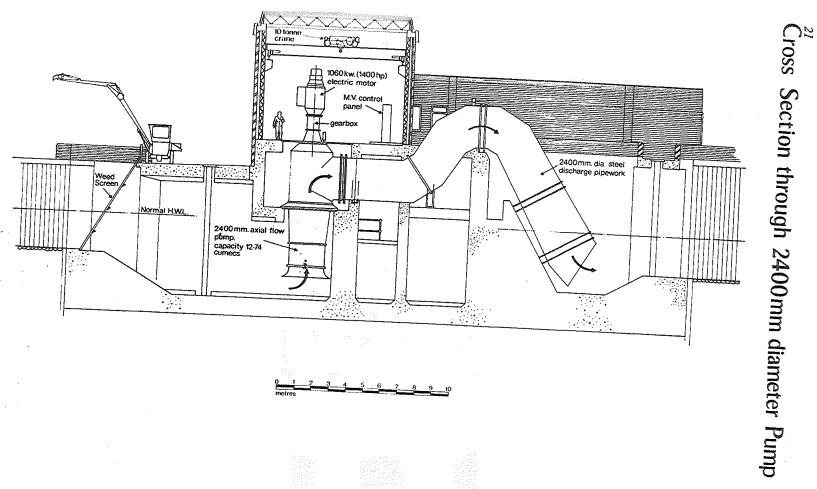
Sluice gate position, pump status, power supply and ancillary equipment are also continuously monitored at the pumping station. When a rising tide is detected, the Trent/Idle sluice gate is automatically closed to prevent the tide running from the River Trent to the River Idle. The gate remains shut while the River Trent level tidally rises and falls to below the level of the River Idle, at which point the Trent/Idle sluice gate would open and allow gravity discharge. During periods of heavy rainfall and when the Trent/Idle sluice gate is closed, pumping is required. When the water levels upstream reach specified levels, the pumps are enabled. Pumping takes water from upstream of the pumping station sluice gate to below it; the pumping station sluice gate closes; when pumping starts the water level builds up in the river channel between the two sluice gates; when the water level between the sluice gates is higher than in the River Trent, the Trent/Idle sluice gate opens. Pumping continues until the River Idle water levels upstream of the pumping station are higher than in the River Trent. The pumps are then disabled and the pumping station sluice gate is opened to allow gravity discharge.
During dry summer periods, to assist with maintaining adequate supplies of water, the gravity gate will not allow the River Idle water level to fall below 1.7 metres AOD at West Stockwith through unnecessary discharges into the River Trent. During times of flood conditions, if the River Trent level does not fall below the River Idle, the gate is unable to operate, consequently the lower reach of the River Idle acts as a receiving pond for waters draining from the higher part of the catchment.
The capacity of the pumping station is approximately half the peak flood flow of the River Idle. To cater for the situation where flow in the River Idle is greater than the pumping capacity, balanced storage will be taken up in the washlands by controlled spillage over the side weirs in the minor banks. In the area of the River Idle Washlands, two sites exist under the Reservoir Act 1975. These are defined as retaining more than 25,000 m3 of water. One area is to the east of Misson and the other to the west of Misson. The Environment Agency are the operators of the reservoirs and have ultimate responsibility for reservoir safety. The Environment Agency is the Enforcement Authority under the Water Act 2003 and we are keen to demonstrate total compliance and best practice, and we are subject to regular audits. The control regime of the pumps at West Stockwith allows all pumps to be operational before any overtopping of the minor banks occurs.
Positive Action in the Catchment
Positive Action in the Catchment
Strategies
- The 25 Year Environment Plan
This plan describes the goals for improving the environment, it includes how we will work with other people to achieve this. There is a summary version here for you to read At a glance: summary of targets in our 25 year environment plan - GOV.UK (www.gov.uk)
- Humber River Basin Management Plan
The RBMP is a 6 year plan that sets out the objectives and actions for the Humber river basin district. This sets out the current state of the water environment and the challenges it faces. You can read the plan here Humber river basin district river management plan: updated 2022 - GOV.UK (www.gov.uk)
- Flood Risk Management Plan 2021 to 2027
Flood risk management plans (FRMPs) set out how organisations, stakeholders and communities will work together to manage flood risk in England. You can read the plan here: https://www.gov.uk/government/publications/humber-river-basin-district-flood-risk-management-plan
- Area Licensing Strategy
This strategy sets out how we manage water resources in the Idle & Torne Management Catchment. You can read it here Idle and Torne abstraction licensing strategy (ALS) - GOV.UK (www.gov.uk)
Environmental Land Management Scheme
ELMS is the new Environmental Land Management Scheme, this is to promote sustainable farming incentives through funding for nature and landscape recovery improvements.
More information can be found here, Environmental Land Management (ELM) update: how government will pay for land-based environment and climate goods and services - GOV.UK (www.gov.uk)
High Flow abstraction study
The High Flow study aimed to improve understanding of the influences of high flows in the catchment and whether additional abstraction when the river was in spate would result in negative ecological impact. High flows are important for managing levels in the Idle Washlands SSSI. Spate flows are believed to wash out fines and stop the sedimentation of gravel river beds which is an important habitat consideration. Further study is required.
Groundwater recharge and working with natural processes
Taking action to restore natural processes can help to make catchments more resilient to flood and drought events. Slowing down the rate at which surface runoff enters river systems can increase infiltration storage within the groundwater of the catchment. Opportunity maps have been produced focusing on the catchments of the rivers Poulter, Meden and Maun to show where actions are most likely to be effective in supporting groundwater recharge. Actions include improving soil management, creation of water meadows, modifying the structure of the forest and partially blocking ‘dry’ valleys to enhance infiltration recharge rates.This report can be read here https://catchmentbasedapproach.org/wp-content/uploads/2021/08/Idle-and-Torne-Working-With-Natural-Processes.pdf
Water for farmers and wildlife
In partnership with the RSPB, the project explores sustainable land management techniques and resilience to land flooding. It assesses the environmental, farming and flood risk management risk and benefits associated with occasional land inundation, including soil quality improvements, higher yields, reduced reliance on fertiliser and pesticides and improved habitats.
Agricultural water resources advice visits
Environment Agency and Natural England’s Catchment Sensitive Farming (CSF) officers have trialed new water resources advice visits at a number of farms in the Idle and Torne. These visits collated sustainable water-use best practice techniques and provided advice to farmers on improving their management of water.
Water resources communication and engagement work
Nottinghamshire Wildlife Trust project to engage schools and the agricultural sector. Engagement sessions in schools provided pupils with information resources to take home and improve domestic water usage. Please contact Nottinghamshire Wildlife Trust for more information on this.
Climate change scenarios
Climate change projections indicate that summer low flows could be less than half current low flows by 2050. We may experience an increase in droughts and water restrictions. Higher winter rainfall will likely result in increased size and magnitude of flood flows. A Leeds University project is focusing on the impacts of climate change on the River Idle and provides an opportunity to better understand potential river flows and water availability impacts to abstractors. It will also consider how we can improve management of water resources in the future.
Detail of the project can be found on the project overview webpage hosted by Leeds University.
Saving Worksop & Shireoaks through NFM
A successful funding bid for Defra’s recent NFM funding pot has meant that there will be on the ground activity in the Worksop area to tackle flood risk. This will be delivered by Nottinghamshire Wildlife Trust in partnership with Nottinghamshire County Council and the Environment Agency.
The project was awarded £1.2M to deliver a series of interventions across the River Ryton catchment to slow flows and store water.
Activity in the Catchment
We work with internal and external partners every day to strive for environmental enhancement and protection. We have a dedicated team to work with partners to develop and deliver projects for the benefit of the environment, and we have a budget to contribute to such projects. We look to achieve multiple benefits in everything we do, we believe this is the most effective and efficient way to work, achieving the best value for public money.
Please see the River Idle CaBa (Catchment Based Approach) page for up to date information on past and ongoing project activity in the catchment, Idle - CaBA (catchmentbasedapproach.org)
Ongoing Investigations
Ongoing Investigations
Watercourses can be vital to maintain land drainage for food production and to reduce flood risk, but any work on them must be undertaken in an environmentally sensitive way. In the past, river management often worked against natural processes.
In recent years scientific evidence has proved that more natural and sustainable management often affords greater flood protection to people and property, while also providing significant benefits to wildlife, water quality and the landscape.
The RIMP group are aware of the EA’s current plans to look into making the River Idle a more efficient catchment which, if approved, will include a redevelopment of West Stockwith Pump Station and a review of the assets in the area such as flood banks and a further review into the conveyance of the river.
West Stockwith Pumping Station – High Voltage Improvement Works
West Stockwith Pumping Station drains the River Idle catchment and works in tandem with two major sluice gates that help to manage water levels and flood flows from the River Idle into the tidal River Trent.
This project aims to deliver required improvements to the West Stockwith pump station High Voltage switchboard systems to address modern procedures for operation and ensuring the sustained safe operation of the asset into the future.
The works are due to be completed in the near future.
West Stockwith Pumping Station Investigation works done to date
It has been identified through planned preventative maintenance that some components in the station are coming up for renewal or refurbishment. Investigative have been undertaken over the past 12 months to understand the condition of the varying components in the station, in particular the pumps and the High Voltage equipment.
We have produced an updated future scheduled maintenance regime to enable the sustained operation of the asset. This balances the planned and preventative maintenance needs of the station with the available funding. To do this on the pumps we have reviewed the number of hours that the pumps originally had as a design life and compared this with the pump run hour records for the station. This has shown that the pumps are not yet at the end of their design life despite their age, and will not form part of the investment in the station at this stage.
Funding Opportunities
Funding Opportunities
There are various government grants available at different times of the year. These can be found on the .gov website here Home - Find a grant (find-government-grants.service.gov.uk) .
NEIRF
- The Natural Environment Investment Readiness Fund
- Apply for a grant from the natural environment investment readiness fund - GOV.UK (www.gov.uk)
Environment Agency – Environment Programme
- This is a fund facilitated by the Environment Agency local area Environment Programme team. For more information on how to obtain funding, contact your local Catchment Coordinator or get involved with the Idle Catchment Partnership hosted by Nottinghamshire Wildlife Trust. Find the link in the links section.
Severn Trent Water
- There are several funding opportunities available through Severn Trent Water and these do change from time to time, so we would recommend looking at their website directly. At the time of writing, these are their current funding schemes;
-
- Severn Trent Community Fund | About Us | Severn Trent Water (stwater.co.uk) This community fund is open all year round for applications
- Severn Trent launches Great Big Nature Boost campaign | News releases | Media | Severn Trent Plc The Great Big Nature Boost releases fuds each year for applications. Keep checking the website for updates or get involved with the Idle Catchment Partnership for regular updates about the catchment and funding.
- STEPS (Severn Trent Water Environmental Protection Scheme) Severn Trent Environmental Protection Schemes (STEPS) | Catchment Management | Environment | About Us | Severn Trent Water (stwater.co.uk)
-
Local Levy
- These are funds raised by Regional Flood and Coastal Committees (RFCC) for regional flood risk management priorities
- Bids are made on a project by project basis and reviewed by the RFCC
- The LIAMS scheme has £415,000 of local levy allocated.
Woodland
-
- Forestry England: England Woodland Creation Offer
England Woodland Creation Offer application form - GOV.UK (www.gov.uk)
CSF
- If you are in a Catchment Sensitive Farming area with a Natural England Catchment Sensitive Farming Officer (CSFO), then depending on options, suitability and criteria, you may be eligible for a grant.
- You can look at the areas here Catchment Sensitive Farming: reduce water and air pollution - GOV.UK (www.gov.uk)
Related
-
High Flow Study - Idle and Torne16.7 MB (PDF document)
-
River Idle Washlands Water Level Management Plan5.4 MB (PDF document)
-
Aquifer Designations in MAGIC Map – Landscape – Geology and Soils
-
National groundwater recharge assessment under climate change
Capital Projects
Lower Idle Asset Management Scheme (LIAMS)
The scheme includes the refurbishment of West Stockwith Pumping station and wider catchment measures to provide an optimum standard of flood risk to communities along the Lower River Idle.
You can find out more information on the LIAMS page.
Audiences
- Community groups
- District and parish councils
- Drainage associations
- Environmental bodies
- Farming associations
- Fishing clubs and representative associations
- Flood action groups
- Flood Resilience Forums
- IDBs
- Land owners
- Lead Local Flood Authorities
- Local authorities
- Local Risk Management Authorities
- Members of the public with an interest in the river, the species and conservation
- Recreational and commercial river users
- RFCCs
- Water companies
Interests
- Flood management
- Habitats and wildlife
- Specific projects, issues, or activity pages
Share
Share on Twitter Share on Facebook