Tenbury Wells Flood Risk Management Scheme
Overview
Page created 18 September 2020. Last updated 20 May 2025.

Tuesday, 20 May 2025:
Please note: This platform will be closing at the end of May 2025. We will continue to keep the community informed about the Tenbury Wells Property Flood Resilience scheme through alternative channels.
We are holding a drop-in event on 2 June at the Regal, Tenbury, from 4pm - 7pm for anyone who would like to come and speak to the project team about property flood resilience.
Friday, 21 March 2025:
This platform may be closing at the end of March 2025. In preparation for this, and while we investigate other options, we will continue to collate our distribution list so that we can update interested parties periodically. If you are not already on the mailing list and would like to be added, please submit your name and email, referencing 'Tenbury Wells', to us at: Tenbury.FRMS@environment-agency.gov.uk
Tenbury Wells flood scheme update:
-
The Environment Agency has been working with partners and the community to propose a flood scheme for Tenbury Wells in Worcestershire
-
The scheme would include walls, embankments and flood gates to help reduce the risk of flooding to the town from the River Teme and Kyre Brook
-
There is a shortfall in funding and the project cannot progress further at this time
-
The Environment Agency remains committed to supporting the community of Tenbury Wells, and Property Flood Resilience (PFR) measures and Natural Flood Management (NFM) activities are being explored to increase flood resilience in the town
The Environment Agency has worked with partners and the local community in Tenbury Wells to propose a flood risk management scheme for the town consisting of flood walls, embankments and 20 flood gates.
However, a review of the scheme design in 2024 showed that for it to be developed it would require a further £8-13 million of funding. This would be on top of the £17.2 million that had already been allocated.
We are keen to help increase resilience of the community to flooding, through Property Flood Resilience (PFR) measures and Natural Flood Management (NFM).
We are working with partners on Natural Flood Management measures for the Kyre Brook and will be looking where other such measures could be appropriate.
PFR measures could include flood resistant doors or door barriers, non-return valves and pumps as well as waterproofing, amongst other options.
We are fully committed to supporting Tenbury Wells in looking at alternative options to help better protect those impacted by flooding and we will do everything we can to support the community. We remain open to the possibility of a built scheme in the future if the funding is available.
We will provide further updates as soon as we have them.
Environment Agency Drop-in event - Tenbury Wells
We held a drop-in event with an update on the Tenbury Wells Flood Risk Management Scheme on Friday 7 March 2025 5PM – 7:30 PM at The Pump Rooms, Teme St, Tenbury Wells WR15 8BA.
At the event we provided the community with an update, as well as creating an opportunity for residents to speak to us face-to-face. Around 50 members of the public came to speak to us at the event and spoke to members of the Tenbury Wells project team. We are looking at more ways to engage in the near future, and we will update our website and mailing list when we know more.
Flooding in Tenbury Wells
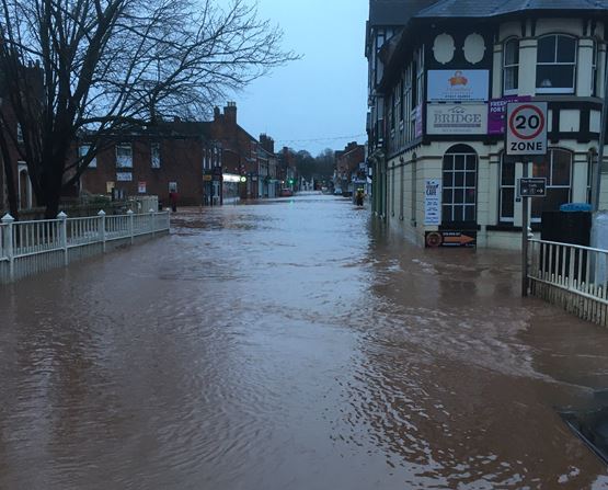
Tenbury Wells in Worcestershire is situated on the banks of the River Teme. A tributary, the Kyre Brook, also joins the River Teme in the town. Tenbury has suffered from extensive flooding to large parts of the town on several occasions, most recently in October 2023, February 2020 and in November 2019, when levels were just below those which occurred in 2007. The community is at risk of flooding from both the River Teme and the Kyre Brook.
These flooding events impact on people’s homes, businesses and the local economy. Transport links and commuter routes through the town are also affected when flooding occurs. Both the River Teme and the Kyre Brook have a long history of flooding.
Tenbury Wells also has a rich history, with both environmental and historic features throughout. These include a number of listed buildings within the town and the River Teme being a Site of Special Scientific Interest (SSSI). We are consulting with Historic England and Natural England and will continue to work with them to safeguard these assets as much as possible.

How to Keep in Touch
Keeping you up to date on our progress with PRF and NFM measures for Tenbury Wells is very important to us. We will continue to provide updates through this information page and via our mailing list.
If you would like to receive our mailing list, please email your contact details to Tenbury.FRMS@environment-agency.gov.uk or call our National Customer Contact Centre during office hours on 03708 506 506 and we will add you to the list.
PLEASE NOTE - By providing us with your contact details you consent to the Environment Agency using the details provided to contact you with updates about the Tenbury Wells Flood Risk Management Scheme. We will keep your contact details until the project is closed or until you withdraw your consent, whichever is sooner. You can withdraw your consent to receive these updates at any time by emailing us at Tenbury.FRMS@environment-agency.gov.uk or calling 03708 506 506. We will not share your details with any other third party without your explicit consent, unless we are required to by law.
The Environment Agency is the data controller for the personal data you provide. For further information on how we deal with your personal data please see our Personal Information Charter on GOV.UK (search 'Environment Agency personal information charter') or contact our Data Protection team. Address: Data Protection team, Environment Agency, Horizon House, Deanery Road, Bristol, BS1 5AH. Email: dataprotection@environment-agency.gov.uk
Remaining Flood Aware
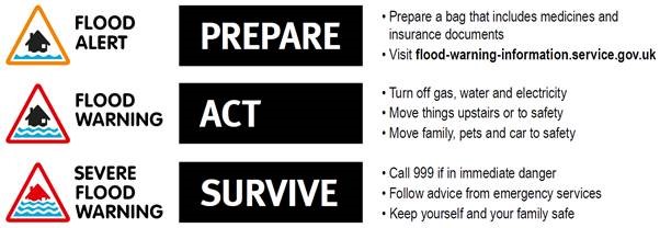
Please make sure you remain flood aware and ensure you are signed up to our flood warning service. Visit www.gov.uk/sign-up-for-flood-warnings or call 0345 988 1188 to sign up to get Flood Alerts and Warnings by phone, email and/or text message. This is a free service. Alternatively contact our Flood Resilience Engagement Advisors at Floodresilience@environment-agency.gov.uk
Know what to do when you receive a flood warning - use the 3 point plan.

Thank you for visiting our information page.
If you have any feedback about this page, or use assistive technology (such as a screen reader) and need a version of any document in a more accessible format, please email Tenbury.FRMS@environment-agency.gov.uk or call our National Customer Contact Centre on 03708 506 506.
Please tell us what format you need. It will help us if you say what assistive technology you use.
Audiences
- Fishing clubs and representative associations
- Businesses
- Charities
- Statutory organisations
- Members of the public
- Elected representatives, including MPs
- Local councils
- District and parish councils
- Land owners
- Farming associations
- Water companies
- Community groups
- Flood action groups
- Environment Agency colleagues
- Lead Local Flood Authorities
- Flood Resilience Forums
- Town and parish councils
Interests
- Business and industry
- Flood management
- Habitats and wildlife
- Specific projects, issues, or activity pages

Share
Share on Twitter Share on Facebook