Bungay and the Surrounding Area Flood Risk Management Scheme - information page
Overview
Welcome to the Bungay Flood Risk Management Scheme information page.
The Environment Agency have created this page to provide easy access to information on the Bungay project. We will be updating this site as the project progresses, so please keep checking back for what's new.
If you would like to be added to our mailing list to receive updates on this project, please email Enquiries_EastAnglia@environment-agency.gov.ukagency.gov.uk
Last update: October 2022
Background
In December 2020 East Anglia received an exceptionally high amount of rainfall, the River Waveney area received 50mm in 18 hours, and a total of 71mm in 96 hours.
Across Essex, Suffolk and Norfolk we issued Flood Alerts to 21 different areas and Flood Warnings to 16 locations during the flooding between 24 December and 2 January 2021. The flood alert for the tidal River Waveney from Ellingham to Breydon Water was in place and updated every 8 hours from 6pm on Christmas Eve to 10am on 2 January 2021.
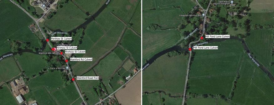
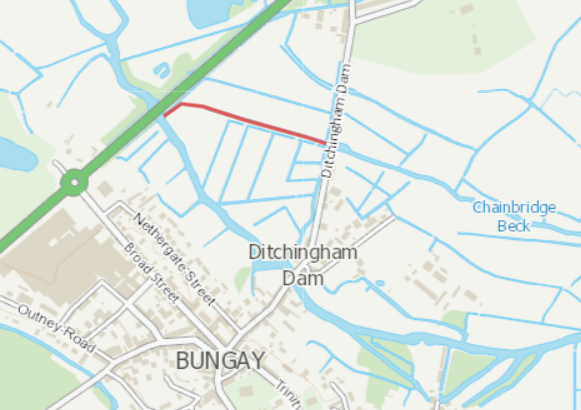
Between 23 and 29 December 2020 flooding occurred in Bungay specifically, Bridge Street and Outney Road and in the surrounding areas which included; Ditchingham Dam, Earsham and Wainford Mill. The primary source of flooding was from the River Waveney and surrounding watercourses. 35 properties have reported experiencing internal flooding with a number of additional reports of external flooding, and potentially more impacted properties going unreported.
What's happened so far
Following the flooding that took place in December 2020 the Environment Agency began work to better understand what happened, working with County, District and Parish Councils and the local community. This included a public drop in event on 19th January where local feedback could be heard and next steps to progress the project was detailed.
Working with our flood risk consultants Jacobs, we have begun to investigate measures for managing flood risk within the area, with the aim of identifying a technically and economically viable scheme that will reduce flood risk with no adverse environmental impacts. The flood risk model for the River Waveney has been updated to help improve the understanding of flood risk in and around Bungay and this is now being used to help inform the project.
We have drawn up a list of possible options to manage flood risk in the area and we are keen to hear your feedback.
Our initial options
The shortlist is based on initial findings and is a long list of options to consider. As a government body we have to ensure any option provides enough benefit (through economic analysis) for the cost to implement an option. If the scheme progresses to a more detailed assessment, there is a possibility that this may rule out some of the options.
At this stage it’s important that we identify a wide range of option and assess if any are potentially viable to included within Strategic Business Case.
We want to understand the communities views and highlight any opportunities on options listed below, for us to then consider in our business case.
More Information
More Information
More Information
More Information
More Information
More Information
More Information
More Information
More Information
More Information
Give us your views
The consultation has now closed.
Next Steps
Comments and feedback on the long list of options will be collated to help inform the short list of options to be taken forwards for further development. We will continue to share updates on how the project develops.
Contact
You can sign up to receive updates on this project by emailing: Enquiries_EastAnglia@environment-agency.gov.ukagency.gov.uk with the title 'Bungay Flood Risk Management scheme'
Audiences
- Recreational and commercial river users
- Fishing clubs and representative associations
- Members of the public with an interest in the river, the species and conservation
- Businesses
- Charities
- Statutory organisations
- NGOs
- Members of the public
- Elected representatives, including MPs
- Local councils
- Academics
- All water abstractors
- Environment Agency customers
- IDBs
- Local authorities
- District and parish councils
- Environmental bodies
- Land owners
- Farming associations
- Drainage associations
- RFCCs
- Elected representatives, including MPs
- Water companies
- Members of the public
- Recreational and commercial river users
- Community groups
- Flood action groups
- Environment Agency colleagues
- Lead Local Flood Authorities
- Local Risk Management Authorities
- Flood Resilience Forums
Interests
- Flood management
- Habitats and wildlife
Share
Share on Twitter Share on Facebook