Alconbury Brook Flood Alleviation Scheme - information page
Overview
Through the Alconbury Brook Flood Alleviation Scheme, we are developing a way forward to reduce the risk of flooding from the Alconbury Brook in Alconbury and Alconbury Weston.
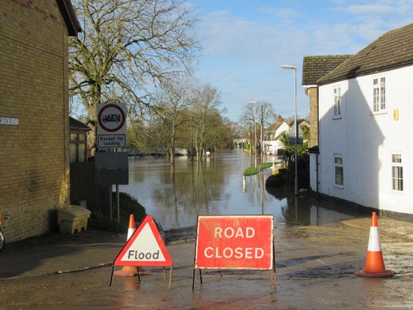
Flooding in Hamerton Road, Alconbury Weston, January 2021
Background to the scheme
The Alconbury Brook catchment is relatively ‘flashy’ in comparison to the wider River Great Ouse catchment, meaning that is reacts quickly to rainfall and the onset of flooding can be rapid.
Both Alconbury and Alconbury Weston have an extensive history of flooding, notably in 1998 when, unfortunately, more than 100 properties flooded across both villages, and in winter 2020/21 when over 75 properties were flooded.
Records also indicate that properties have flooded in March 1947, July 1968, October 1987, November 2000, and March 2016.
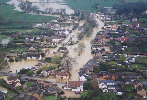 Alconbury Weston flooding, Easter 1998
There are currently no formal flood defences in Alconbury or Alconbury Weston. Our previous studies to develop a flood alleviation scheme for the villages have been unsuccessful in identifying viable options. These either had an unacceptable impact on village aesthetics or, based on the costs and benefits of a scheme, were unable to be eligible for government Grant in Aid (GiA) funding.
We are reviewing options for a flood alleviation scheme, with the aim to identify a technically and economically viable scheme that will reduce the risk of flooding to the villages. The introduction of the Partnership Funding approach for flood risk management projects since the previous Alconbury study means that the project is now more likely to be eligible for a contribution from GiA funding, but will require additional contributions from partners.
What’s happened so far, engagement, and next steps
Working with our consultant (Jacobs), we reviewed previous project appraisals and identified new options to develop a long list of potential flood alleviation scheme options.
We’ve been working closely with the Alconburys Flood Group, as well as other stakeholders including Cambridgeshire County Council and the Bedford Group of Internal Drainage Boards to help us develop the scheme. Their input has been hugely valuable in building our knowledge of past flooding events and impacts. The Flood Group members reviewed our initial set of scheme options to reduce flood risk, and their feedback helped us to refine those on the shortlist.
Keen to hear feedback from the wider community, we held a public drop-in event on 14 June 2022, attended by over 80 people. We also ran an online survey for people to give us their comments and feedback on the shortlisted options.
Our initial shortlist of options
The shortlist is based on initial findings and a very high level of analysis. If the scheme progresses to a more detailed assessment, which will include hydraulic modelling, there is a possibility that this may rule out some of the options. At this stage it’s important that we identify a potentially viable scheme that can be included within Strategic Outline Case. Where options could be combined or undertaken as supplementary options to a ‘main’ option, this would also be investigated at the next stage.
The shortlist is split into 2 sections:
- the 3 main options that we believe could give sufficient flood risk benefits to give a viable scheme (described below and available in a pack in the download section at the end of the page)
- the 6 complementary options that we believe could have some benefit, but would need to be undertaken in combination with other options (these are available in a pack in the download section at the end of the page)
More Information
Advantages:
- Outside of the villages – reduces direct impact on community.
- Potential for tree planting, wetland creation and river meanders which will likely have a positive landscape and potential Biodiversity Net Gain benefit.
- Likely to have some benefit to both villages, though expected that the greater benefit will predominantly be to Alconbury Weston. Likely to work better in combination with other viable option/s in order to provide sufficient flood risk benefits to both villages.
- Likely require concrete culvert structure. Culverting of a watercourse will have negative impacts on aquatic and riparian habitat.
Your browser does not support inline PDF viewing. Please download the PDF.
More Information
Option: Diversion Channel with flood storage area directly upstream of the diversion channel (adjacent field) to increase benefit to the village.
Advantages:
- Combined option includes some benefit to both villages.
- Potential to create new habitat and community benefits within flood storage area (flood meadows, wetland and/or shallow ponds).
- Requires removal of garages and likely requires concrete culvert structure (culverting of a watercourse will have negative impacts on aquatic and riparian habitat)
- Believed the Reprofiling Option will have a greater benefit with the removal of the fords.
- Potentially extensive excavation works depending on size/location of storage area if required to encroach on land of rising ground levels to the south.
- Potential disruption to existing ecology/habitats.
Your browser does not support inline PDF viewing. Please download the PDF.
More Information
Option Cumulative Storage: The Alconburys Flood Group believe around 40 offline ponds would result in a modest impact on flood risk.
Advantages:
- Outside of villages – reduces direct impact on community.
- Potential to create new habitat and community benefits within flood storage area (flood meadows, wetland and/or shallow ponds).
- Considered unlikely to significantly reduce flood risk to Alconbury and Alconbury Weston as a standalone option.
- Multiple storage areas comparatively potentially greater cost than an equivalent volume single large storage area.
- Likely require concrete culvert structure. Culverting of a watercourse will have negative impacts on aquatic and riparian habitat.
Project update: August 2022
Following June’s community drop in event, we have been reviewing the feedback received both on the day and via the project web page. In total, we received 49 pieces of feedback (16 on the day, 33 via the project web page).
Feedback on the shortlisted options
Of the shortlisted options presented:
- the Reservoir – culverted bund (upstream of Alconbury Weston) received the largest amount of positive feedback. Of the responses that indicated a preferred option for the scheme, the majority stated that it was their 1st choice.
- the Culverted bund – flood storage area upstream of Hamerton + cumulative storage was the second most popular option
- Reprofiling at Alconbury and short diversion channel with a flood storage area at Alconbury Weston only received a small amount of positive feedback and was the only option to receive negative comments.
Feedback on the complementary options
The feedback indicates the popularity of each option as follows (most to least popular):
- Two Staged Channel downstream of Alconbury
- Channel reprofiling / improvements at Alconbury
- Long Diversion Channel (to Cock Brook)
- Natural Flood Management
- Improved Conveyance downstream of Alconbury Weston
- Property Level Resilience
It’s important to stress that the complementary options are those that we believe could have some benefit, but they will need to be undertaken in combination with other options. They will not be considered in isolation.
What happens next?
Based on the feedback received, these shortlisted options will be taken forward:
- Reservoir – culverted bund (upstream of Alconbury Weston)
- Culverted bund – flood storage area upstream of Hamerton + cumulative storage
We’ll now undertake an economic assessment for these options to better understand their economic viability. If a viable option is identified, this will be included in a Strategic Outline Case for us to seek to obtain funding for the next stage of the project.
We will investigate whether options can be combined or undertaken as supplementary options to a ‘main’ option at the next stage of the project. Based on the feedback received, all the complementary options remain ‘on the table’ and we will factor in preferences on these when scheme options are developed and refined.
We’ll share further project updates on this web page as we further develop the options. We’ll also continue to share updates with the Flood Group for their newsletter.
Project Update: May 2023
Following the feedback received from the local community on the shortlisted options for a potential flood alleviation scheme for Alconbury and Alconbury Weston, an economic assessment was undertaken for the following options:
- Reservoir – culverted bund (upstream of Alconbury Weston)
- Culverted bund – flood storage area upstream of Hamerton + cumulative storage
The aim of this assessment was to investigate the economic viability of the options and to establish whether there was sufficient justification to progress to the development of a Strategic Outline Case for the project.
Economic Assessment
The results of the economic assessment show that, based on the evidence available, neither of the shortlisted options are economically viable. The costs associated with delivering the options are greater than their economic benefits, meaning that they do not represent good value in line with Treasury funding rules. At this stage, we are therefore unable to develop a Strategic Outline Case for the project using the evidence available.
Whilst this is disappointing, we remain fully committed to investigating options for a viable scheme for Alconbury and Alconbury Weston. To do this, we are proceeding with recommendations from the economic assessment and updating the hydraulic model for the Alconbury Brook. This is being done with the aim of improving the evidence base that will inform the assessment of potential options for a flood alleviation scheme.
Next Steps
Work to update the hydraulic model has already commenced with the collection of new channel survey cross sections in late 2022.Our consultant (JBA) has devised the methodology of how the model will be constructed ahead of commencing the model build. We anticipate that initial results from the updated modelling will be available later this year.
This page will be updated when more information becomes available and we will continue to engage with the Alconbury and Alconbury Weston Flood Group throughout the process.
Alconbury Brook Natural Flood Management Project
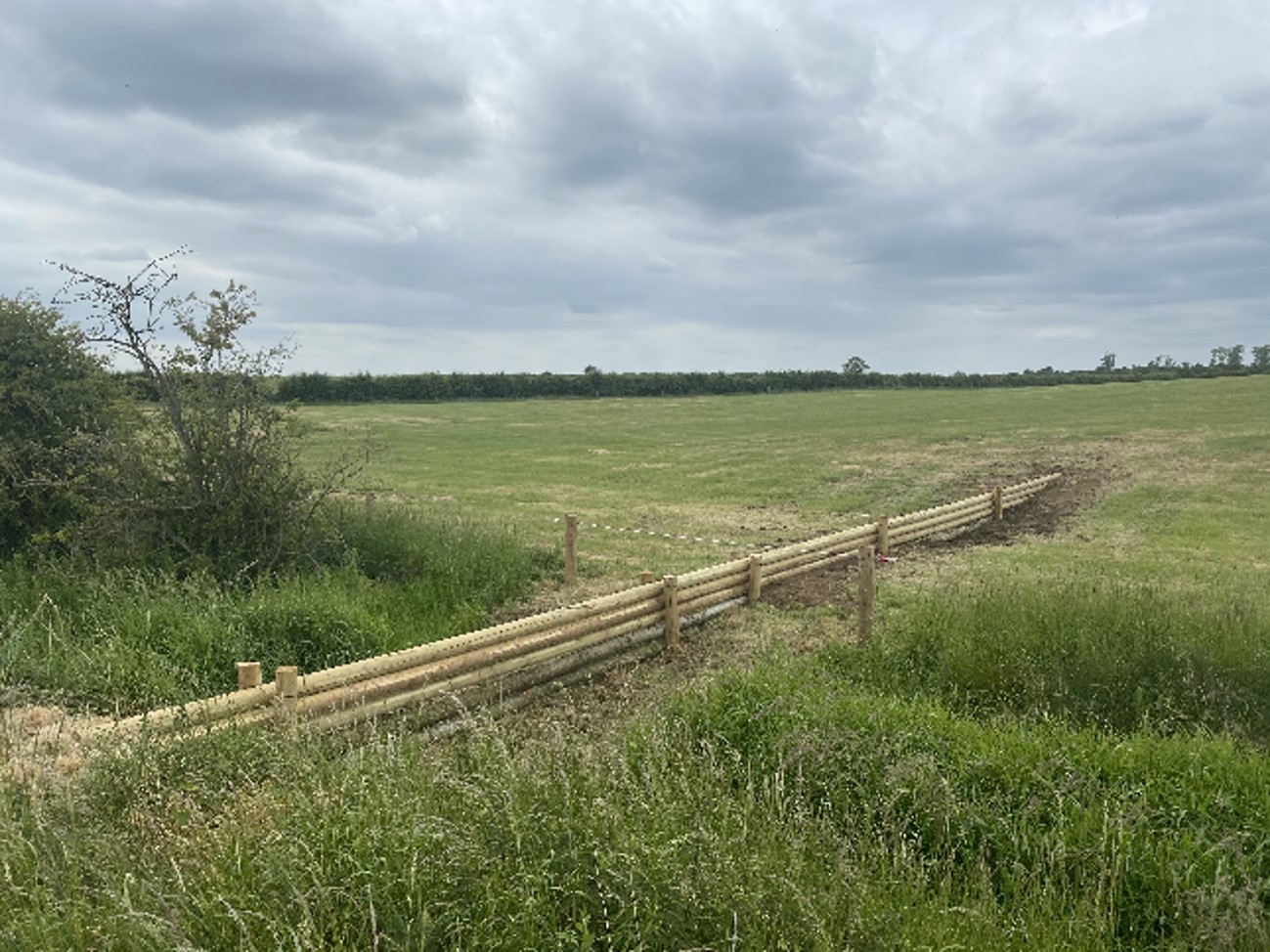 NFM project at LWS Milton Estate (Rectory Farm)
The Alconbury Brook Natural Flood Management (NFM) Project is part of a £15 million national pilot NFM fund launched by the government to determine the effectiveness of NFM solutions in different catchments. It has been running since 2018 and is due to be completed this year. It is a partnership between Natural England’s Countryside Stewardship Scheme and the Environment Agency.
NFM measures can not only help to reduce flood risk, but also improve water quality and habitats by working with natural processes and utilising soft engineering techniques.
NFM measures installed include:
- leaky woody structures
- desilting ponds to increase capacity
- 2 new ponds, including one providing 2000m3 of storage adjacent to the Mile Brook near Steeple Gidding
- sediment traps to hold back sediment and water from farmyards
- tree planting
New monitoring stations were installed which will help to provide evidence of the effectiveness of existing and future NFM measures in reducing flood risk and improving water quality. The success of this project, and considerable engagement with landowners and farmers in the catchment, has resulted in a long-term future for NFM in the catchment. We are now working closely with the Alconburys Flood Group who are keen to develop NFM more widely in the catchment, by building on the farmer and landowner engagement undertaken by this project. This will ensure that a truly collaborative approach is taken to NFM and nature recovery in the catchment.
Our flood risk maintenance work
We have spent £147,000 on maintenance in Alconbury since April 2016. The banks of the Alconbury Brook are inspected annually, and the channel is checked for significant blockages and vegetation growth. This inspection is used to plan our maintenance programme. We also respond to reports of blockages, such as fallen trees, and remove them where they present an increased flood risk.
A selective in-channel weed spray and grass cut of the channel sides through Alconbury and Alconbury Weston is undertaken each year, as well as maintaining and repairing Garkies Mill Sluice at the far downstream end of Alconbury Brook.
Being prepared for flooding
There is lots you can do to prepare for flooding and to try and minimise the impact it can have on you, your community and property.
Check if your area is at risk of flooding
- Check if your property is at risk of flooding
- Request information on the flooding history of your property
- If you are new to the area, we recommend asking local people about flooding that has taken place before so you are aware of where there may be risks
Sign up to flood warnings
You can sign up to the Environment Agency's free flood warning service which will send you alerts if flooding is predicted in your local area. This will give you a warning so you can prepare your home or business for potential flooding.
Get home insurance
Make sure you have the correct home insurance cover in case your property floods. The cost of recovery after a flood is on average £20,000. The Flood Re website has been set up to help those who live in a flood risk area find affordable home insurance.
Create a personal flood plan
The personal flood plan includes a list of things you should do and provides space for you to note down important contact details such as your utility companies and insurance. The Environment Agency has created a personal flood plan template you can use.
Flood protection products
There are many different types of equipment you can purchase which will offer different levels of protection to your home in the event of a flood. The National Flood Forum has produced an independent directory of flood protection products and services called the Blue Pages.
Keep your drains and grids clear
Removing leaves and debris that are covering the top of your grids will help prevent blockages which could cause localised flooding in heavy rainfall.
If you own property next to a water course for example a river, culvert, brook, or mill stream, it's your responsibility to keep the bed and banks clear of anything that could cause an obstruction and increase flood risk. Find about your rights and responsibilities of riverside ownership.
We'll add further information to this web page as the scheme develops. If you have any questions, please do get in touch with our project team.
Audiences
- Recreational and commercial river users
- Fishing clubs and representative associations
- Members of the public with an interest in the river, the species and conservation
- Businesses
- Charities
- Statutory organisations
- NGOs
- Members of the public
- Elected representatives, including MPs
- Local councils
- Environment Agency customers
- Environment Agency colleagues
- Lead Local Flood Authorities
- Local Risk Management Authorities
- Flood Resilience Forums
- Town and parish councils
- Regional Flood and Coastal Committees
Interests
- Flood management
- Habitats and wildlife
Share
Share on Twitter Share on Facebook